Trip Dates: Friday, Aug 25 2023 to Sunday, Aug 27 2023
Total Elevation Gain (m): 4000
Total Trip Time (days): 3
Total Trip Distance (km): 121
Peaks Ascended: Smoky, Goodair (Roaring Ridge, Snort)
Quick ‘n Dirty Rating: Class 2/3- you fall, you break something.
Difficulty Notes: One of Banff National Park’s most remote valleys and series of peaks. This is a fairly serious off-the-grid trek and you should come prepared for swift creek crossings, fickle weather, trackless Rockies landscapes and very loose and unstable slopes.
Technical Rating: TL2, OT4, SC6; RE5
GPS Track: Gaia
Map: Google Maps
Ever since looking down into the wild and lonely Roaring Creek valley from the summit of Cataract Peak in 2017 Phil Richards and I wanted to trek through it. Since then we’ve poked around the edges of one of Banff National Park’s most remote landscapes including an ascent of Mount McConnell in 2018 and a trip up the very south end of the valley in 2022 on route to Whimper Peak. I’ve read Rick Collier’s report of his ventures there many times and it only inspired more wanderlust. Rick’s route into the area from the valley south of Mount McConnell didn’t sound that appealing to us with tough navigation and glacier crossings. Rick’s route took 5 very tough days to complete a loop sneaking through the upper Roaring Creek valley with two ascents along the way – Smoky Mountain and Roaring Ridge (Mount Goodair). Seeking more beta on this area isn’t very productive – there isn’t much of it to find. In 2019 Erik Nilsson completed a spectacular and daring traverse from Mount McConnell into the headwaters of McConnell Creek. From there he traversed to the headwaters of Roaring Creek and eventually somehow managed to get into Three Brothers Lake and exit via the Fish Lakes trail. This is next level stuff! M.P. Bridgland writes of the Roaring Creek valley in the 1929 CAJ;
Opposite the mouth of Martin Creek, Roaring Creek enters from the south. This stream derives its name from the roar of a waterfall about seventy feet high, just where it enters the main valley. Roaring Creek Valley is an open U-shaped valley extending about eight miles to the south. It is evidently of glacial origin, as shown by the formation of the valley itself and by the hanging benches along the west side. The main peaks on both sides average a little over 10,000 feet, and Cataract Peak, the highest in the vicinity, reaches an elevation of 10,935 feet. The glaciers and snowfields on the north and east faces of this peak form one of the main sources off Roaring Creek, while the slopes to the south and west drain to Pipestone River.
The rumor is that the 1919 topographical survey completed a first ascent of Smoky Mountain but since then there’s a legitimate question of whether or not they actually reached the highest point or a slightly lower one to the west. There are no records of their being in the Roaring Creek valley on the Mountain Legacy website. In the 1930 CAJ, J.W.A. Hickson writes (in reference to standing on the summit of Cataract Peak with Walter Feuz),
We could see down Roaring Creek to Martin Lake. Immediately to the North between our Peak and Clearwater River, there stood out on both sides of this creek, half a dozen unclimbed summits over 10,000 ft., and of varying attractiveness.
“Of varying attractiveness” – LOL. In the 1970 CAJ, William Putnam writes about a massive 16 day traverse he organized in the summer of ’69 to determine whether or not the “great Cambrian cliffs” indicated on the new 50,000 series of Dominion maps were really there. Along their travels his group snuck through the upper Roaring Creek and McConnell Creek valleys following the incredible line of cliffs that were indeed there. In researching the area and reading about others adventures to the area, I came to the inevitable conclusion that only a certain type of explorer puts foot to ground in the Roaring Creek valley. The kind who doesn’t give up easily and the kind that is willing to suffer a little more than most.


Phil and I thrive on obscurity and the over the past 4 or 5 years we’ve managed quite a few trips into the extreme eastern Banff valleys. Phil is more of a landscape explorer and I lean more towards bagging peaks so we tend to make a pretty good team when we join forces. After a possible 2nd ascent on Cuthead Peak in mid-August, we were busy planning a trip back into McConnell Creek with a traverse back out through Roaring Creek. In July 2020 we made our first trip up the north branch of McConnell Creek, discovering an old outfitter trail and making some rare ascents of Boar Station, Bellow and Howl peaks. Other than terrible mosquitoes, the trip was pure hiking magic and we wanted to return almost immediately after completing it.
Time flies and here we were 3 years later finally planning a return. This time Phil had a doozy of a route planned out. Instead of simply going up the north branch of McConnell Creek and then exiting the same way, we hoped to go over a high col between Smoky Mountain and Mount LeBlanc into the Roaring Creek valley. Our exit would be via another high col that we knew Erik Nilsson took on his 2019 trip between the headwaters of Roaring and McConnell Creek. Of course we planned to do all of this while bagging a couple of remote peaks and in only 3 days.
Day 1 – Bighorn Falls – Red Deer River – McConnell Creek – Smoky Tarn
We left the Bighorn Falls parking lot above a very full Bighorn Campground at 08:30 on our bikes. We’ve both biked this road through the lovely Tinda ranch many times but it’s always easy, fast and beautiful. After meeting Brandon Boulier along the way, we continued to the park boundary and bison fence and unfortunately the end of our ride. I’ve said it so many times but I’ll say it again. WHY can’t we bike the old Cascade fire road through Banff?! I know with the bison introduction it’s never going to happen but dang – it would be so much more efficient than walking that road every time we go into this area! Sigh. We locked the bikes to a nearby tree and continued on foot through the fence, frustratingly following two very fresh sets of bike tracks continuing past the “no biking” sign into the park. Sigh. The next 2.5 hours were a fine mix of pleasant hiking on an easy road and deep sighing over the bike tracks we were walking on. Neither of us wanted the stress of a $25,000 fine if caught on the 2-wheel steeds here, but it was hard not to feel like suckers as we walked over fresh tire tracks reminding us that we could have been traveling this section much quicker and easier. Sigh.


Just before arriving at the bridge over the Red Deer River we veered west continuing on the much smaller Red Deer River Trail. The fresh bike tracks predictably ended as the trail grew smaller and we debated theories as to where the cyclists were headed. (We definitely got that one wrong!) The next few hours slowly soaked our souls back into the surrounding wilderness. It’s kind of funny and kind of ridiculous but we both commented that peaks like Wapiti, Tyrell and even Mount White feel like “front range” to us after so many longer trips up the Red Deer and Clearwater rivers into eastern Banff. Whatever the sanity of it all, the trail was familiar in a good way as we trundled along, noting bison wallows, elk tracks and bear scat. It’s hard not to get romantic on this wonderful area of the Alberta Rockies. Sure! There’s no huge peaks or impressive glaciers but there’s green valleys, rolling hills and soaring cliffs nonetheless. The blue waters of the Red Deer River run down beside the trail and clear creeks gurgle and chuckle their way across the path to join in on the fun below. Every time we approached familiar bison grazes we grew silent, hoping to see them again. It didn’t happen, but the anticipation made the hiking fun.


Finally, after over 5 hours on the approach we returned to the meeting place of the Red Deer River and McConnell Creek. With a lot of excitement and a little bit of dread we turned north up the east side of the creek, remembering the bushwhack that precedes the old outfitter trail. It didn’t take long, however, for one of us to ask the obvious question. Why not simply stay in the creek for a while? The water was much lower than it was in July 2020 when we were last here and we could join the trail further up before the creek narrowed into rapids. This idea worked perfect and after half an hour in the creek (easy hiking) we turned sharply right and after a short bushwhack intersected the old outfitter trail. (On return I chatted briefly with Tim Barton, the owner / operator of The Outpost At Warden Rock. Tim told me that he originally cut in this trail in the 1960’s as a horse trail and used it for many years before letting it slowly fade. I made sure to thank him for his efforts.) We managed to follow the trail to its abrupt end at a gravel outflow under SW slopes of Boar Station.


In 2020 we’d desperately searched for a continuation of the trail on the far side of the outflow before giving up and bushwhacking into the North McConnell Creek valley. On return we’d taken a highline to avoid the worst bush. This time we were smarter. We decided to stick in the creek to the junction of the main and north branches. From the junction we hoped to take advantage of beta from Scott Eveleigh’s “brown streak” adventure in 2022 when he’d passed through the area. Scott indicated that he found traces of a trail from the “Two Lake” camp down to the junction on a forested rib west of the north branch of McConnell Creek. Back in 2020, after our trip, Phil was digging around and found a fascinating tale involving a centennial commemorative climbing camp by park wardens from across Canada in memory of six fellow wardens giving their lives to the job. The objective laid out by the expedition states;
Since the inception of our National Parks six park wardens have lost their lives in the line of duty. In 1929 Percy Goodair was killed by a grizzly bear in Jasper’s Tonquin Valley. In Riding Mountain National Park Lawrence Lee was shot by poacher(s) in 1932. James Brink and Robert Marak died when their patrol vehicle was struck by a transport truck in Banff in 1972. In 1981 in Banff, Neil Colgan died after being kicked by his horse while on backcountry patrol. Also in 1981 Robert Leblanc was killed in a firefighting accident in Kouchibougeiac National Park. To commemorate 100 years of Canadian National Parks, and to recognize the dedication to duty of the Warden Services across the country we will request the Canadian Permanent Committee of Geographic Names to designate the mountains surrounding the north fork of McConnell Creek as the Warden Ranges, and to name six of the peaks climbed after these men.
Scott writes (and I now agree) that he thinks that the 16 wardens and their 30 horses (!!) used the old outfitter trail up the east and north sides of McConnell Creek from the Red Deer River and only crossed to the other (NW) side of the creek at the gravel outflow before continuing up to the Two Lake camp in lighter forest. Sticking in the creek was a very good decision. Gazing across the valley at the highline route we’d taken 3 years previous was exhausting just looking at it. The creek was cool, we had access to unlimited water on a hot summer day and travel was very straightforward. Finding a nice waterfall with a well-defined trail up and around it was a bonus. Eventually the creek became a little boney – slow and awkward travel – and we bailed onto the forested rib to our right, hoping to find traces of the trails that Scott found a year earlier.


The rib worked well and without any dire bushwhacking we quickly gained height until we found ourselves in familiar alpine meadows near Two Lake camp. The lake twinkled its green and blue hues behind us as we continued up steep meadows on a spectacular highline traverse far above the north branch of McConnell Creek and its willowy guardians.


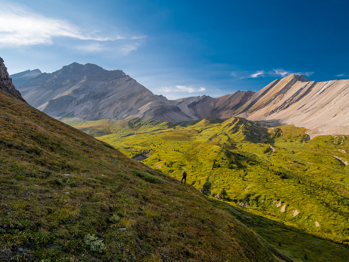
We were very excited to be back in this magical landscape and as the sun continued its downward journey to the west we were not disappointed by the incredible views opening up all around us. Bellow and Howl Peak showed up at the NE end of the valley as we slowly progressed around an east outlier of Mount Leblanc. We descended scree and grass slopes north of the outlier and stayed above the willowed valley towards the lower tarn SE of Smoky Mountain – now visible rising above the valley to the NW.


We passed by the lower tarn, pausing to make sure we had the energy and desire to camp at the middle one as planned. Despite some gusty winds giving me slight pause, we decided to continue on to camp right under Smoky Mountain. We still had enough daylight and energy to get to the middle tarn. The next hour or so was pure magic. The shadows continued to stretch as we hiked alpine meadows to the large, blue middle tarn. Too bad the water was shaded when we got there as this is one of the darkest blue waters I’ve ever seen. We set up a spectacular camp at the north end of the tarn right under south slopes of Smoky Mountain – and yes, we had the requisite backcountry permits to be there.

It was a long day to get into this wild place! We spent 11.5 hours traveling 48 kilometers and ascending over 1200 meters to our little corner of paradise. We ate supper quietly, taking in our surroundings before climbing into our respective tents for the night. Sleep was pretty good for a first night out, despite the wind popping the main tent peg at 02:00, forcing an emergency evacuation and reassembly in the dark. No swearing was had – I promise. (Ok I lied. There was some.)
Day 2 – Smoky Mountain – Roaring Creek – Mount Goodair – Roaring Tarns
I woke at 05:00 as usual for me – I get sore after 6 or 7 hours in a tent – and tossed and turned until Phil’s alarm at 06:00. The days are getting shorter towards the end of August and it was still quite dark as we broke camp and prepared for a day of exploration and new terrain ahead. We were both psyched as we left camp, slowly ascending scree and boulders towards the lower south scree shoulder of Smoky Mountain above camp. The terrain was deceiving at first but eventually everything eased off as we snuck our way above an upper tarn to the infamous tilted scree ledge leading to the true summit. An hour after leaving camp we left our packs on a rubble slope and started to the summit of Smoky Mountain, hundreds of meters above us on easy terrain.


Only 90 minutes after leaving our packs at the bottom of Smoky Mountain’s south rubble ledge we were back, ready to finally ascend the Leblanc / Smoky col and continuing into the mythical Roaring Creek valley on the other side! Despite the big day before and the morning’s efforts we were full of excitement and energy as we topped out at the col and took in the incredible valley below. With no beta on this route we were taking a chance on it, but as indicated on the satellite maps we had no issues descending rubble slopes down a huge west drainage to treeline below. The plan from there was to follow treeline south, staying out of the willows and forest below to reach the NW ridge of our next objective, Mount Goodair.


The next 2.5 hours were a summer 2023 highlight, no doubt about it. People are always encouraging me to go places outsides of the Alberta Rockies but the advantage of sticking to “home turf” is that we get to some pretty darn special corners of the paradise in our own backyard. Of course there are beautiful places all over the planet, but why chase after them along with everyone else when you can experience such peace and beauty right here at home with a much smaller carbon footprint as a bonus? (Rant: we all claim to be mortally concerned about the state of our planet but then we all visit the crap out of every corner of it as if that’s going to help it somehow. We complain about the tourists in Lake Louise but then we go to someone else’s “Lake Louise” and do the exact same thing to the locals there. #youcanthaveitbothways) As we wandered at treeline over creeks and meadows slowly donning their fall colors we marveled at our fortune to have this as our backyard. We dipped and bobbed through several small alpine valleys and over ridges coming off of Mount Leblanc, Mount Colgan, Mount Marak and Mount Brink – all looming ominously high above us to the east. I had routes planned up the west sides of many of these peaks but views from valley bottom weren’t that inspiring for most of them with very rotten looking rock and steep slaps. Little did I know that the very next day someone would be traversing all of them!


I wondered what our next peak would look like as we slowly rounded the west shoulder of Mount Marak and took in our first views over the wild NW ridge of Mount Goodair. Cataract Peak, Little Cataract Peak and Dip Slope Mountain were a wall of rock to the west, towering high over the aptly named Roaring Creek valley. Waterfalls cascaded down the steep cliffs from dying glaciers still stubbornly clinging to impossibility sheer walls.


It was hard not to be a little impressed by all the stuff going on around us and perhaps it slowed us down. Whatever it was, time was slowly ticking away as we finally gained the NW ridge and my planned ascent route for what Rick and Boles call “Roaring Creek Ridge”, the 1985 wardens called, “Mount Goodair” and bivouac dubbs, “Snort Peak”.

After a successful ascent of Mount Goodair, we returned to the overnight packs and after a short break started a descent into Roaring Creek. We were finally dropping into valley bottom, crossing it on route to some hidden alpine lakes and tarns tucked under the east cliffs of Little and “Big” Cataract peaks.


After a short stint in reasonable forest through the creek we started a wandering ascent up a series of scree ramps, rock ledges and small meadows to the largest lake under Little Cataract. Along the way we passed several smaller lakes and an interesting spot where the creek ran underground and disappeared completely from sight and sound.


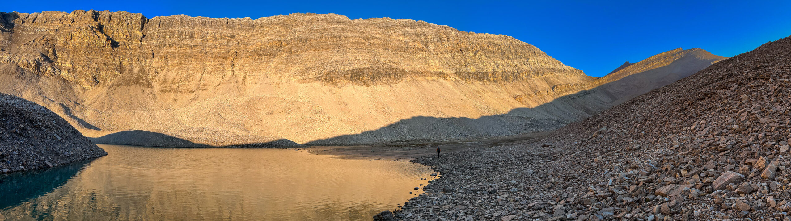
We debated staying at a smaller tarn just under the upper lake in case of a wind event like the night before but we both wanted to see the lake while there was still enough light to actually see it! We knew that the following day was going to be a long one and we’d be up early enough that the lake would be mostly dark as we exited. A few deep sighs and grunts later and we finally found ourselves at the north end of the large lake.


We’d been on the move now for over 12.5 hours and light was fading fast as we took in the wild scene in front of us. A family of mountain goats grazing the shore only increased how wild this place felt as we finally took in the deep blue waters of a lake we’d been dreaming of seeing in person for many years.


After taking it all in, we crossed the outflow stream, taking our shoes and socks off in order to keep them dry for the night and next morning. I can’t remember the last time we did that! We managed to find some nice tent sites near the outflow and set up a wonderful little camp for the evening. Supper tasted pretty darn good after a long day and by 21:00 we were both turning in for the night.
Day 3 – Roaring Creek – McConnell Creek – Red Deer River – Bighorn Falls
My phone battery was low so Phil agreed to set his alarm for 05:30. When he yelled over to “get your butt outta bed!”, I died a little inside. I was sure it was earlier than 05:30 by how dark it still was and wanted to snuggle deeper into my warm sleeping bag. I have never slept so good in the backcountry as I did along the upper Roaring Creek lake. For some reason the combination of not worrying about bears (too high) and the calm night with water bubbling past added up to a sublime overnight. Phil didn’t admit it right then, but he did set his alarm earlier than the agreed time after realizing how big our exit day was. It was closer to 05:00 than 05:30 when we got up. I’ll be remembering that next time he complains about an early start! 😉 After a morning coffee and slowly packing up camp we set off down the eastern shore of the large upper lake, hoping to catch sunrise on the east cliffs above at some point along the way to the high col between the Roaring Creek and McConnell Creek valleys.

As the day before, wandering along the moraines, tarns and streams of the upper Roaring Creek valley was a highlight of the summer. The sun slowly rose to the east and before long the stone walls to the west were catching the orange glow and reflecting in the water surfaces around us.


We ascended to a high col before taking in our last views down Roaring Creek and dropping into another striking landscape under the severe cliffs and glaciers comprising the north faces of east outliers of Forgotten Peak towards Mount McConnell and its outlier peaks. We were expecting a lot of very slow and difficult travel on rubble and boulders through the upper section of McConnell Creek but were pleasantly surprised by how everything kept reasonable.

As we slowly worked our way along to treeline again, Phil noticed a large cairn off to our left on a lateral moraine. WTF? We wandered over to it but that was all there way – just an obvious rock cairn sitting there as if placed the day before! It reminded us once again that more and more folks are pushing into the deep backcountry looking for new adventures nowadays. Lighter gear, different travel methods and good fitness is allowing folks like us to access and experience areas in 2 or 3 days that used to take almost a full week of hard and slow travel to attain. Not far from the first cairn we spotted another, this one at a prime campsite along the creek.


As the hours ticked by we continued down McConnell Creek, varying between the creek itself and either of its banks. A few waterfalls along the way made things interesting. The narrowest and highest one had the potential to cliff us out but we managed to sneak down on skier’s left right beside the falls on steep dirt and scree.


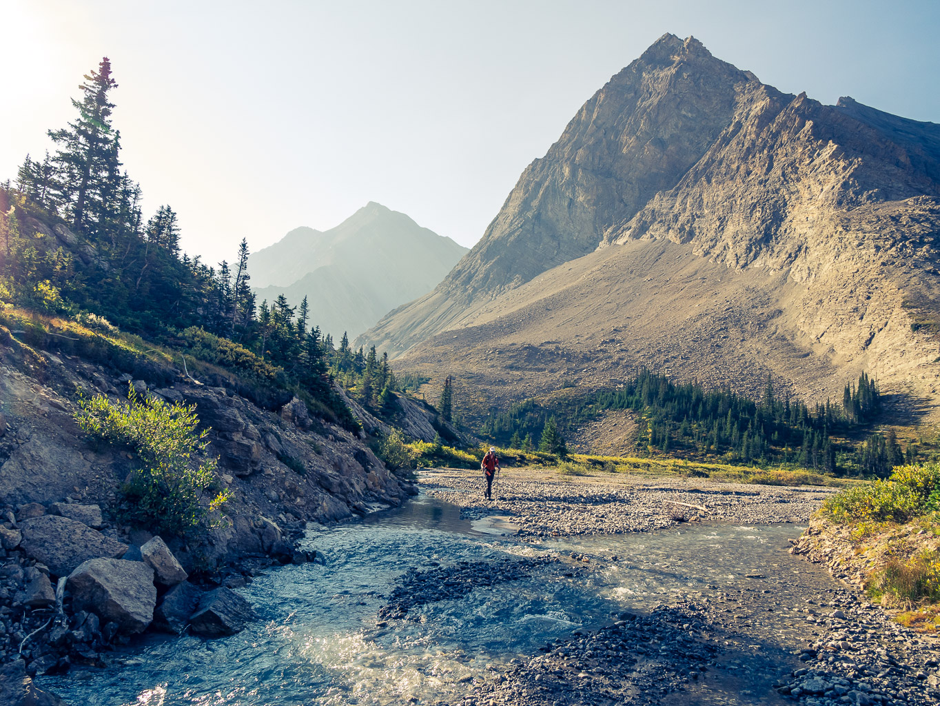


Mount McConnell loomed over us on one side with outliers of Mount Lee on the other as we finally reached open flats along the creek that we’d first spotted two days earlier while on the rib ascending towards Two Lake camp. Thankfully the flats were less swampy than they’d be earlier in the year and before long we were back in the creek and working our way down to join our approach track.


After a brief stint in the creek we rounded a few corners and found our approach tracks. The next few hours were spent under a HOT sun, working our way slowly back down McConnell Creek to the old outfitter trail and then down to the Red Deer River and a proper trail again. Finally, 7.5 hours after leaving our high camp above Roaring Creek we were back on the dusty Red Deer River trail with many kilometers stretching out in front of us under a hot summer sun. After a well deserved break at the junction we continued on.


Another break at a favorite lookout over the Red Deer River provided us with much needed energy on the long march back to the bikes. I’ll be honest, this exit felt much easier and less of a slog than previous ones have for some reason. I think it was the nice long break above the river and the great sleep I had the night before. Whatever the case, 2 hours after rejoining the Red Deer River trail we were back on the old Cascade fire road for the familiar death march to the bikes. Again, this section wasn’t that bad considering the miles we had on our feet, the heat of the day and the fact that we were once again sighing over the thought that someone else got to exit this whole section on their bikes! There were long sections of quiet hiking and sections of chatting as we slowly passed Mount White, Tyrell and the massive bulk of Wapiti.


Almost 12.5 hours and over 38 kilometers after leaving our camp above Roaring Creek we were back at the bikes. Phew! That was a long hike under a hot sun! As usual the bike ride resurrected deeply buried energy somehow and we made short work of it other than a fairly long chat with Tim Barton regarding horse trails he’d cut in the area over the 40+ years he’s lived and worked here. Chances are that if you’ve stumbled across trails in the most obscure places from Halstead Pass to Roaring Creek, he had something to do with it. We arrived back at the Bighorn Falls parking lot 13 hours and 51.5 kms from the start of our day.
What more can I say? This trip lived up to everything I thought it would be. A fantastic backcountry adventure in pristine landscapes, exploring some of the last remaining untouched and largely untraveled wilderness along massive Cambrian Cliffs of the Alberta Rockies along the source streams of two of Banff National Park’s major drainages – the Red Deer River (McConnell Creek) and the Clearwater River (Roaring Creek). Thanks as usual to Dr. Phil, the trip planning guru and to me the routefinding drill master dragging us up peaks along the way. As long as our bodies and life allows, I’m sure we’ll continue to stumble and bumble our way into new corners (for us) of the Rockies somewhere or another – as rare as those corners seem to be getting.