
Elevation Gain (m): 2400
Trip Date: May 27, 2017
Round Trip Time (hr): 68
Total Trip Distance (km): 53
Mountain Dukkha
Buddha says that most of life’s suffering is caused by an endless cycle of human craving for impermanent things and states of being, which is dukkha – incapable of satisfying and painful. By trapping ourselves in this continuous state of craving things that don’t last, we are caught in an endless cycle of rebirth, dukkha and dying, or samsara. Only by attaining nirvana can we be liberated from this path of suffering.
I’m considering the possibility that Mount King Edward – or likely all mountains in general – is my samsara. Might I be caught in an endless cycle of craving something on the next mountain top that the last one didn’t fully satisfy – for whatever reason? I am cognizant that often the most satisfying adventures might not be “successful” in the classically defined sense of reaching the original goal, such as a summit. Some successes might be born of traditionally defined failures. Sometimes coming out on top may mean not even getting to the top at all! Case in point – this past weekend on Ben and my second attempt and second failure at our goal to stand tall on the summit of Mount King Edward, a Canadian Rockies 11,000er. Was this trip a failure or a success for us? Making the question much more interesting is the fact that a third member of our party – Steven Song – did make the summit, while we watched him do it from far below. Intrigued? Read on.
Last year around the exact same time period, Ben and I made our first attempt at this gorgeous peak. Due to minimal overnight freeze (i.e. none), we packed up and headed home, disappointed to put all of that time and effort into a “failure”. I remember feeling pretty bummed about it for a few weeks. Over the years I’ve managed a pretty strong success rate when it comes to standing on the top of mountains that I’d set out to do. This is much easier in hiking and scrambling than mountaineering simply because the objectives are usually much easier to plan for and be flexible on. Much of my high success rate was due to extreme flexibility and planning around weather and conditions. I’ve also gotten very lucky on many of the larger objectives and I’ve taken some chances that on hindsight weren’t very smart either.

Lately, I’ve slowly gotten more and more disillusioned and disheartened over attaining peaks just for the sake of it. It can be such a selfish, empty and ultimately meaningless enterprise when it’s pretty much all you focus on in life. And it’s not without costs either! Mountains have cost me incalculable amounts of family time, personal expense and even relationships. More and more often, I catch myself feeling like Sisyphus, except my boulder is a backpack and instead of a Greek god forcing me into an endless cycle of pointless toil, my Zeus is either lists of summits defined by others, or a self imposed correlation between summits, self-worth and meaning in my life. I know from talking with other mountain enthusiasts that I am not alone in this particular dukkha. I suppose nirvana isn’t easy. Sometimes we have to learn the hard way – life lessons are rarely attained through easy, and possibly lucky, success.
Learning the Hard Way
The Plan
The last week of May, 2017 was shaping up to be a pretty darn nice one. Long term forecasts just kept getting better and better until not planning something big, seemed like a waste of the weather god’s generous and rare gift. After the usual emails and Facebook messages finished swirling and bouncing around the globe, it was a regrouping of the little adventure group of Ben Nearingburg, Steven Song and myself that decided a King Edward redux was in order. As mentioned earlier, in 2016 Ben and I were part of another attempt at this remote 11,000er at much the same time (early June). Most folks do King Edward in late summer or early fall to take advantage of a lower Bryce Creek and a clear glacier to avoid the many crevasses on route to the south face. In these conditions it’s usually a rock route with a few low-fifth sections. After seeing Trevor Sexsmith and Ian Button’s east face ascent and ski descent in 2015, Ben decided that skiing the south face would be an ideal and interesting way to climb Kind Eddy. Obviously, I agreed.
The challenge with climbing King Eddy safely, in late May or early June, is that five things that normally don’t line up, must align or you will be forced to take high-consequence risks. The five things are;
- Good weather (i.e. clear)
- Cold (i.e. hard overnight freeze)
- Low Bryce Creek
- Dry and drivable Bush River FSR
- Lots of snow (i.e. good coverage on glacier and south face)
The problem is that some of the 5 things above don’t align with each other very easily. In order for the road to be in good shape, it must be dry. This implies hot weather to melt snow and release avalanches early so that they can be cleared off the road. Lots of snow means that the road might not be cleared to the end. Lots of snow implies a high Bryce Creek, especially if it’s warm weather. Low snow melt implies less coverage on the glacier and more chance of thin snow bridges or crappy weather, preventing a melt. Cold temperatures imply bad weather at the end of May. Clear skies, implies warm or hot weather. The incongruities go on and on. But since we’re all pretty optimistic, we decided to go for it anyway. Sometimes you just have to put the analysis and predictions to the side and tackle an adventure with enthusiasm. It rarely works out but it can produce a heckuva tale!
The Approach
Ben and I met at around 15:00 at the Lake O’Hara parking lot before continuing on to Golden where we’d be meeting Steven at Josee’s place around 16:00 or so. Steven stopped by Ian Button’s place in Golden to grab a chainsaw in case of deadfall on the Bush River FSR before proceeding to Josee’s house. Ben and I had a delightful hour or so visiting with Josee who was a very gracious host along with her three energetic dogs. The weather was very warm down in the valley and honestly we talked about the fact that it was very likely too bloody warm to be planning a south face snow climb for the weekend. Eventually Steven showed up and it was nice to visit after a couple of years since we last saw each other. We transferred all our gear to Steven’s truck and soon we were bombing along the TCH for the turnoff to the Bush River FSR near Donald, BC.
It was a hot, dusty evening but the road was largely clear of traffic by the time we started the long drive to the King Eddy parking area. We noticed some fresh road work around the Sullivan River Road intersection – a good sign of the road being actively maintained, likely in preparation for the 2017 logging season. We drove quite a few more pleasant KM’s before Steven suddenly exclaimed that our good luck was ending. Sure enough! Just ahead of us was an obvious, fairly fresh avalanche blocking the entire road. As we got out to examine it closer, it was obvious that our second serious attempt of King Edward was going to be over long before it even started. Unfortunately for us, we required a bulldozer to get rid of this obstacle and Ian didn’t own one of those to lend us. Huh.
But wait a dang minute! I quickly blurted out the question,
How far are we from the end of the road?
GPS units were deployed and brows furrowed over the question. Soon the answers starting coming in. Ben thought we were around 15km or so and I quickly agreed that it was around that far (I actually thought it was slightly further at close to 17km, but who’s counting). Fifteen kilometers isn’t that far is it? With a road to walk on, we could easily maintain a 4km/h pace and could even dampen the pain by wearing our running shoes and carrying our heavy mountaineering boots. Navigation in the dark wouldn’t be an issue as we had headlamps and the road is pretty bloody obvious anyway. It was only when I slightly adjusted the wording that we had second thoughts;
This means we’re adding 30+ kms to our trip total.
GULP. Thirty extra kilometers sounded a wee bit crazy. Remember – this is full-on winter mountaineering. We were packing skis, snowshoes, large boots, crampons, axes, ropes, glacier safety gear, rock gear, tents, stoves, fuel and warm clothing including down jackets, fleece and other glacier camping necessities. This wasn’t a day hike with Aunt Edna to Three Isle Lake. This was a full backcountry expedition. Sure! It was only a few days but that only changes the amount of fuel and food we carried – everything else we needed to pack was pretty standard whether it was a week, or a 3 day long trip. We stood outside the truck looking forlornly at the pile of avalanche debris while the early evening sun shone brightly down on us and the sounds of the Bush River and it’s many local inhabitants wafted through the dry air and took over our senses. What the heck. Why not? Let’s do it! Life is short and we’re here now. Nobody really felt like any of our alternate plans and what’s 15km between friends? Four hours of walking? Meh. No problem.
Twenty minutes later, after hurriedly stuffing our large packs with the requisite gear (we were expecting lots of time to do this at the end of the road later that evening) we were tramping off down the Bush River road. It was around 20:30 – we would be getting to sleep well after midnight. Our ideas of a leisurely camp with lots of time to eat, load gear and prepare for our trip were gone. We were into things much earlier than expected – but this is the nature of trips like this. You can’t be too rigid or you might as well stay home. Nature doesn’t give a crap about your emails or schedules. She just does her thing and you either have to accept and adapt or go home. Your choice. She doesn’t care one bit either way. Steven and I both decided to absorb the extra kilometers in our running shoes to try save our feet on the hard surface of the gravel road. Ben decided to walk in his ski boots. This sounds crazy, but he also walked all the way to Mount Forbes via Glacier Lake this way so he’d done it before. (It’s still a bit crazy though. ) Ben also decided to bring his skis instead of snowshoes. I had my skis along in the truck, but once the extra 34 kilometers got added to the itinerary, I quickly chose the ‘shoes over the snow sticks. I’m a sucker for punishment, but even I have my limits! Ben was just coming off a 27 day ski traverse along the Great Divide route so he was still firmly in ski mode. Thank goodness he has short and very light skis – this detail will become crucial later in this tome.

Tramping down the Bush River road was quite pleasant for the first few hours. Birds were chirping in the BC forest next to the road. The sun was warm, but not too warm. There was a slight breeze carrying the intoxicating scent of spring. Views were intermittent but very impressive, as usual for this area of the Rockies. Cockscomb and Bryce stole the show across a roaring Bush River while the Chess Group and other unnamed peaks loomed over us to the west. We chatted about all the many exciting trips we’d been on since last going out together and as the shadows grew longer and our feet grew hot spots from the concrete-hard road surface we slowly grew quiet and let the monotony of long distance hiking with a heavy pack take over our senses. Running into a large black bear and a huge (think grizzly bear cub size) porcupine broke the monotony a bit and reminded us why we wrapped the truck with chicken wire. There were three large trees downed over the road – that chainsaw we borrowed from Ian certainly would have been very handy for these if we’d managed to drive further. Finally, after three hours or so we reached the bridge over a roaring Bush River, just before the Bush River FSR intersects the much smaller South Rice Brook road, which leads to the Bryce and Alexandra approaches. We took a break here. Originally Ben had us excited that we only had 2km to the end of the road. That didn’t sound right, however, so I pulled out my GPS and confirmed that it was closer to 5.5km. Darn. Nothing to do at this point but shoulder the packs and push onward – and as it turns out – upwards. As night settled in we donned our headlamps and slowly continued up the narrowing road. We were all done with the “easy” approach by the time Bryce Creek stopped our progress and marked the end of the Bush River FSR. Our stats for the evening stroll were over 17kms of distance and around 450m of height gain with 300m of height loss. We tried to ignore our sore feet and shoulders as we set up camp on the road. It was bloody warm as we got into our sleeping bags. Alarms were set for 04:00 to allow an early crossing of the creek, which looked higher than a year previous to me.
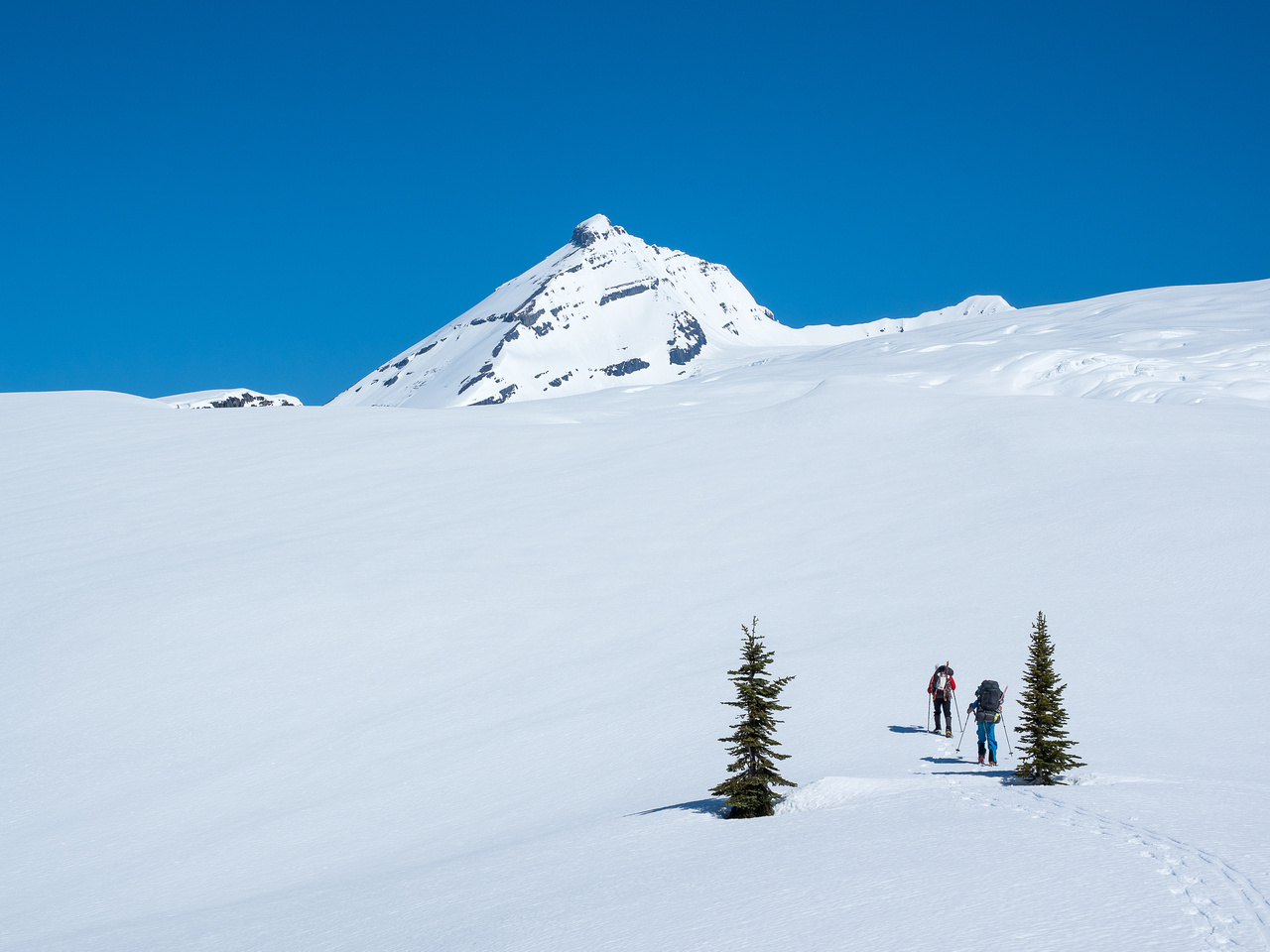
Sunday morning dawned very early! Already at 04:30 it was light enough for no headlamps as we packed up camp and prepared to cross what looked like a fairly deep and fast Bryce Creek. By 05:00 we were dipping our toes into the fast flowing water and taking tentative steps across. The water felt as deep and fast as on the return a year previous when we all felt like we didn’t want it to be any higher. This was at the back of my mind for the next few days as the temperatures soared and the creek inevitably would rise further. By 05:30 we were tramping up the road to the cut-block – a familiar trek for Ben and I. I am always struck by the beauty in this area. I’m not sure if it’s my imagination or not, but the birds seem to chirp louder and the environment itself seems more pervasive than many other areas of the Rockies. Everything is bigger somehow. I’m not gonna lie. I was feeling the previous night’s 17km death march as we ground our way up the overgrown road. Our packs were heavy but our spirits soared, as we enjoyed another gorgeous day in the Rockies. We introduced Steven to the alders on the road – not something you see every day and a bit of a bummer considering how easy the road is above and below this section. The same stream was still running on another section of the road, making us hop, skip and jump around to avoid sopping wet feet. What was vastly different this year compared to the previous, was the snow line. We encountered our first snow much lower on the road and soon Ben could finally don his skis and start skinning which brought a huge smile to his face after carrying the boards around 20km and over 700m vertical to this point! Steven and I were also happy to take the weight of our snowshoes off our packs.


From the snow line on the road, travel was excellent. The temperature got low enough on Saturday night to give us fairly supportive snow all the way to the top corner of the cut-block before entering the forested slopes to the alpine meadows above. Instead of running water and easy bushwhacking, we had at least 3 or 4 feet of snow in the forest. Travel was very easy and fast as we knew the route. Old snowmobile tracks also helped keep us aligned – as the gullies in this section can make you wander off in random directions if you’re not paying attention.


Once the trees started thinning we followed a slightly different route than the year before and as it turns out a slightly more direct route to the tarns and our intended glacier access point from the alpine meadows. Our access was east of an obvious rock buttress that we ascended the year before – GR660745 via a nice uniform snowy ramp. There were no visible crevasses as we finally crested the ramp and took in views of the icefield between us and King Edward. Once again, I was impressed by the view of Mount Columbia’s west face and Cockscomb and Bryce rising behind us. The Chess Group to the west looked fantastic too – with avalanches thundering off it’s steep east aspects. There was some debate about where we should stop for the day but there were pros and cons either way. Going right to the bottom of the south face was better for an early alpine start the next day but meant traveling across the glacier with heavy packs on rapidly softening snow bridges. Falling in a crevasse would suck anyway – but falling in a slot with a fully loaded backpack is even worse! Also, we were only about 1.5km from the south face anyway – not a long distance to travel with lighter packs the next day. With great snow coverage we knew we’d find a way through the crevasse field to the face. There was also the simple fact that we’d traveled over 28 kilometers and almost 2000 vertical meters with heavy winter mountaineering packs over the past 12 hours and did not feel like continuing further with them on.

We set up a cozy camp in decent snow conditions and settled in for hours of lounging and resting at camp – all the while staring at Mount King Edward and it’s snow covered south face and upper gullies. The afternoon sun was relentless and we found ourselves wishing for some cloud cover which never did show up. The snow was obviously very soft around our camp – even on the glacier, but we did a lot of probing to ensure we weren’t on top of any hidden holes.


There were some concerning hints of instability in the snow, that were pretty obvious from our camp on the glacier. First of all, the east aspects of the Chess Group were avalanching constantly throughout the afternoon as temperatures soared and the sun beat down on them relentlessly. These are very steep aspects and include overhanging cornices, glaciers and seracs so this wasn’t 100% relevant to our route. Our intended route was quite a bit tamer and on a south aspect which wouldn’t get sunlight until around 08:00. A much more concerning thing for me, when I peered through my 300mm lens towards King Eddy, was evidence of a recent, big slab avalanche on the same south aspect and as a matter of fact, the very same slope that we intended to climb the next day. The slab ripped out at an obvious shallow rock outcrop and ran right to ground. It was a big one too – propagating at least 350 vertical meters over steep cliffs and running another few hundred meters across the glacier below. It was at least 300m wide too. The thing that bothered me as I studied it was why the heck our slope, immediately to the south of the slide, hadn’t triggered at the same time? How much was our slope disturbed by the neighboring one’s demise? Why didn’t the obvious shallow rocks and convexity about halfway up our slope set off a similar slide? What the heck was our slope waiting for? I would have felt much better if the whole south face had slid rather than just a random part of it. I also noted how black the exposed rock on KE is. That strong spring sun had to be heating those black rocks like coals in a fire – setting off instabilities deep in the snow pack. At least a glacial base won’t heat up the same way a rock one does. The exposed rock was in some interesting places along our intended line of ascent including a couple of visible cracks and couloirs that were showing signs of releasing rockfall and sluffing. I secretly hoped that our slope would rip out that afternoon or even overnight and solve the problem of assessing whether or not it would remain stable long enough for us to finish our climb the next day before finally giving up and just letting go.
We discussed setting tracks to the bottom of the south face for the next morning but nobody really felt like crossing the glacier in the nuclear conditions we were experiencing, so we held off. On hindsight setting some tracks to the face might have been a good idea as there was plenty of coverage on the glacier to keep any snow bridges pretty safe despite the heat. Again – 28km and 2000 meters height gain with heavy packs didn’t help our motivation. After lounging around for hours, we tried turning in early with an 03:00 wakeup time. We wanted to give the snow enough time to set up – if not from a good hard freeze (which we vastly preferred), at least from re-radiation provided we had a clear overnight sky. Trying to fall asleep in the hot tent wasn’t easy but eventually I drifted off with my toque pulled low over my eyes to block the seemingly never sleeping sun.
The Climb
I woke up and my first thought was how warm I felt. This wasn’t a good thing. I’m always cold sleeping on glaciers – especially in the morning. And usually I’m wearing my big down jacket, while on this occasion I was in a t-shirt and my thin Gore-tex jacket. Uh oh. Ben confirmed that the temperature was at around 4 degrees outside as I got out and tramped around camp to see if the snow had set up overnight. It had – marginally. I sunk through a thin crust every fifth step or so. The slight north breeze felt warm! Well, we were here now and there was some firming of the snow, so we decided to eat breakfast and wander over towards King Eddy to check it out.
By 04:15 Steven was leading us over and around some broken up sections of the glacier. Coverage was excellent and by 05:00 we were approaching the bottom of the south face, which looked to have excellent snow coverage right to the edge of the glacier and covering the rocky access to the south face proper. As we transitioned to crampons for the climb, things weren’t looking too bad. The snow seemed more supportive at the base of the slope than it was at camp, although it was still 2 degrees and felt very warm. I was pretty much on Steven’s heels as he started kicking steps up the steep snow to an obvious moat about 100 vertical meters above. Right away, as I followed him up, I knew that our 2nd attempt at this peak was likely over.
I was using one alpine ax and a pole with no basket so that I could assess the snowpack as I climbed (this also works as a handy crevasse probe when crossing glaciers). My ax was pretty much useless in the soft snow but what really concerned me was that my 125cm hiking pole sank easily right to the handle without hitting any resistance in the snow pack whatsoever. When I pulled it out, the snow in the hole it left behind was very blue – i.e. wet. I doggedly kept going and as Steven approached the moat I stiffened once again as another sign of instability made itself known. The sound of a small waterfall running out from under our slope onto the rocks beside me on my left disturbed the still morning air. Yikes! Even worse? When I stopped to listen further, I noticed another gurgling stream of water running out of the slope on the other side of our slope to my right! Jeez. To summarize the conditions I noted on the first 50 vertical meters of climbing to the south face that morning;
- No overnight freeze at this elevation.
- A large to-ground slide at the very same elevation, aspect and even the same slope that we were on, just to our left.
- An open moat above us where the slope is convex as it rolls over from the south face and down steep slabby cliffs to the glacier below (this slope can apparently be quite challenging to climb when dry – it’s pretty steep).
- Another section of exposed rock, higher up the slope with another crack opening up on yet another convex roll – this is the exact line that the other half of the south face had already ripped out along.
- No stability in the snowpack – slushy right to ground and I was sinking knee deep when I wasn’t tip-toeing in Steven’s tracks.
- Running water under the snow – on both sides of our slope, which was sitting on steep, slabby rock – not glacial ice and which had already slid pretty large just off to our left over similar slabby terrain.
Honestly, at this point we all should have turned around and gone home. We knew the forecast wasn’t improving over the next few days for snow travel. We had plenty of warning that the slope we wanted to climb was on a hair-trigger to slide, and had many good reasons to let go, nevermind three people climbing on it and encouraging it even further! We knew that even if the lower slope held us on ascent, the sun would be hitting it by the time we descended sometime after 08:00. Initially we had given ourselves until around 10:00 to exit – hoping for a freeze to stabilize things – but this didn’t happen. I yelled up several times at Steven, asking him about conditions where he was and inquiring how the moat looked as he looked to be struggling a bit with the snow over it. He replied that the snow was very “loose” and he was looking for a way over it. I replied that conditions were looking dicey and it wasn’t safe. He didn’t reply as I turned around and descended a bit towards Ben who was getting ready to ascend just below. I knew that Steven would keep pushing on – such is his modus operandi. But it’s not mine.

The One Who Speaks First
I would like to state at this point, that there is a method to my madness in the next bit of writing, besides personal angst or feelings of defeat. When Steven posted his trip online almost immediately after the trip was finished, the reaction from certain people was to congratulate him on “pushing through difficult conditions” and “successfully bagging the summit” while presumably Ben and I didn’t have the energy or stones to follow. There is much more to this tale than a hard-won summit and two people left waiting far below, without the requisite gonads. It’s the other parts of the story that are especially relevant for any aspiring mountaineers reading it, who might not understand some of the subtleties of ethics and safety that (should) exist within alpine climbing. I am reminded of one of my favorite life quotes that is found in Proverbs;
The first person to speak always seems right until someone comes and asks the right questions.
Proverbs 18:17
In his trip report, Steven talks a lot about speed and soloing difficult winter objectives on his own. Speed is an essential skill in alpinism as often conditions are changing fast and speed is one way to mitigate risks that might be increasing all around you (i.e. sun on snow slopes, rockfall, thunderstorms etc.). Soloing winter objectives is a risky business – there’s no one to dig you out if you get buried – but I couldn’t care less about anyone risking their own lives and suffering the consequences of making their own choices to travel or climb solo. I love traveling solo in the mountains and do it all the time. Trust me – I get the “solo thing”. The problem in this case is that this was not a solo trip and conditions weren’t deteriorating, necessitating speed above all else – they were already deteriorated before we even started out that morning. I’m a fairly laid back guy and on many of my scrambling or hiking trips I have no problem if the people I’m with separate for stretches of time while we each go our own pace or even pick our own routes and get lost in our own thoughts. But alpine climbing in a group is a different game than hiking or scrambling with others – and for a lot of reasons. Taking off on your own isn’t just selfish when you’re part of an alpine climbing group – it’s very dangerous for all the parties involved and here’s just some of the reasons why:
- The person going ahead could (and will) knock down rocks / ice / avalanches on the party he’s left below.
- The group loses it’s ability to make safe and wise decisions regarding everything from current conditions to route choices to turn-around times. More people means more discussion, which can certainly be annoying at times, but nobody is immune to having bad ideas and a group can more easily call each other’s bad ideas out when they’re within talking distance of each other. Nobody likes to turn around – this is why group communication and decision making is essential in mountaineering.
- Half of the group safety and shared climbing gear is in a backpack that is nowhere nearby most of the group members. Not really that useful!
- There is one less member of the group to assist in case of an emergency with any of the other members of the group.
- The soloist uses the group when it suits them (i.e. crossing a glacier or belaying up a cliff) and then quickly abandons them when they become a perceived “burden” – i.e. too slow or too safety conscious.
- The soloist could easily get into serious trouble themselves (i.e. avalanche, serious fall, getting off-route, dislocating a shoulder, medical emergency) which would be difficult for the others to notice, much less assist with. This increases the stress of the people left behind and puts them in an awkward situation when they have no idea what’s going on or how long they should sit and wait below before assuming something bad has happened.
- I’ve been on many easier trips where the person ahead, or behind, gets on a completely different route than the rest of the group. Now what? Many frustrating hours have been spent trying to find each other on easy terrain – never mind difficult and exposed alpine climbs.
Also, it’s a bit rude to assume that the rest of the group wants to sit there for hours watching the soloist risk his or her life playing Russian roulette with conditions that have just been assessed as too hazardous for anyone else to climb. There’s nothing “hardcore” about pushing ahead in this scenario. IMHO, don’t do group trips if you aren’t willing to respect the others in the group over your own glory.
Consider the very real possibility that Steven got caught in a wet slab avalanche half way up the lower third of the south face, or dislocated his shoulder while in the final steep couloir just below the summit? His shoulder dislocated on Sir Douglas – so it’s happened to him before. And what if he couldn’t pop it back in this time? Ben and I would be forced to climb the lower part of the face, over the moats, cracks and convexities on the slope to try to rescue him – exposing ourselves to the very objective hazards that we avoided by turning around in the first place! The way I stated it later to my wife, was that there were two outcomes that Ben and I were forced into as we sat out of the reach of any potential avalanches beneath the south face for over an hour as Steven completed his summit bid high above. Both potential outcomes were not ideal for us, and we didn’t have a choice but to wait it out and see which one would come to pass;
- Our assessment of the risks was correct and happened in front of us, with Steven getting caught in a slide or a bad situation, which we then would have to deal with somehow.
- Steven successfully bags a peak that we’ve spent two attempts and untold amounts of physical and mental currency on and makes it back to individual glory – getting lucky once again considering the conditions and leaving us to wonder why we didn’t take the same risky path he did and question our decision to be safe.
In his account, Steven implies that Ben and I were so far behind him due to our “slow gear transition”, that we basically screwed ourselves out of the summit. This isn’t the case. First of all, Steven was kicking the steps and Ben and I are in fantastic physical shape. We easily would have caught up to him if we didn’t have long discussions about the conditions and express severe doubts in the snow slope’s stability. Secondly – I was literally right behind Steven as we started up the first slope to the first moat – right on his heels. I stopped, turned back, and waited at the bottom of the slope as soon as I heard running water under the 3+ feet of slush that we were on, just in case it slid. I was waiting to see if Steven would survive getting over the first convex roll and obvious weakness at the first moat before starting up myself. This is another group strategy on questionable snow slopes. You cross or climb them one at a time. This is very basic safety protocol that everyone learns in their first avalanche awareness course. If the slope did let go, there would have been two of us to rescue Steven instead of just Ben trying to dig out both Steven and myself.
If he would have bothered sticking around to participate in the discussion, Steven would have realized that Ben and I were agonizing over what all the signs around us were saying and what our hearts and minds were saying. Does anyone reading these accounts really think that the easy thing, in this case, was for Ben and I to turn our backs on the mountain and go back home without the summit for a second year in a row? Really?! Hundreds of kilometers of driving. Many days off. Hours of approach and egress, including crossing Bryce Creek multiple times. Slogging up overgrown logging roads and struggling up many hundreds of vertical meters on soft snow for nothing? C’mon! This wasn’t our first rodeo in the mountains! Ben has climbed many difficult and challenging 11,000ers and literally just came back from a 27 day ski traverse on the same snowpack (Rockies, Great Divide) – does anyone really believe that Ben turned around just because he wasn’t “hardcore” enough to suck it up on a relatively easy angled snow slope and a few couloirs?! That’s a bit insulting to be honest. I’ve done a few climbs on snow myself and even if my cojones aren’t the macho size and heft of the latest batch of younger, bolder, stronger and more confident climbers, I still do “have a pair” – so to speak.
The Luck Jar and the Experience Jar
Despite all the signs yelling at me to turn around and descend back to the glacier and go home, I was too caught up in wanting the peak myself to listen properly. After I waited for Steven to survive the first convexity on the face, I started up again. That’s when I heard the second waterfall on my right. Yes – there were two running waterfalls at 05:30 in the morning, at the base of a loaded slope of slushy snow, sitting on top of black rocks angled at around 30-40 degrees – the most perfectly angled avalanche slopes you’ll ever find. As a matter of fact, since the water was running on each side of the slope, logic dictated that it was also likely running underneath our feet on the same slope – we just couldn’t hear or see it there yet! Dang it. I was getting less and less happy by the second.


Ben, to his credit, was ready to turn back already as I yelled down the latest beta of the second running waterfall down to him. He was sinking knee deep in the tracks and was clearly alarmed at the many signs of danger all around us. Ben was by far the most experienced snow stability assessor in our group, having just completed the Avalanche Operations Level 1 certification this past winter, not to mention his recent 27 day ski traverse on a Rockies snowpack along the Great Divide. Another of my favorite human quirks was quickly coming to pass in front of our eyes – the Dunning-Kruger effect. In short, the DK effect states that the less people know about something, the more confident they are that they are deeply knowledgeable about it or that it won’t affect them personally. Ben, having the most knowledge about avalanches and their danger signs, was by far the most worried about one occurring in the conditions we were experiencing. I was definitely worried, but trying to ignore my own warning bells due to a deep desire to summit King Edward. Steven was obviously willing to silence all the warning bells in his mind – despite admitting later that they were going off like crazy.
I was absolutely loathe to turn around at this point. My gut was screaming at me to turn around before the slope slid and it was too late, but my heart was screaming even louder. All that work to get here for a second year in a row! Steven is doing it! Keep going! Push harder! You’ll be fine! Stop over thinking things! Go on! A few more steps – it might get better. Ben was reluctantly following me up the steep lower slope, and even passed me for a bit as I coaxed him to try ascending a bit higher. We crossed the scary lower moat, which was bound on top and bottom by unconsolidated snow and in the center by a gaping, open maw with soft edges. It looked bottomless as I quickly navigated over it, trying not to think about the consequences of a slough, slip or slide into its dark depths. We pushed on, heading up towards another convexity around two rocks at mid-slope – where the slide beside us had ripped out a hundred meters or so to our left. We stopped a few times to discuss how uncomfortable we both were. We were so desperate to attain the summit this time, that we even talked ourselves into staying up high above all the avalanche terrain until midnight (this would mean hours of waiting) for the snow to harden again for descent. I got a bit higher than Ben and just below the second open crack and convexity on the slope I experienced a small settlement beneath my feet and yelled down to Ben that I was getting the f__k out of there. He quickly agreed and we both turned around to get off that loaded suicide slope as quickly and safely as humanly possible. The descent was scary. We didn’t want to trigger the slope with huge, plunging steps but we both felt we didn’t have time to lose. The moat was more threatening on descent. Easy enough to slither carefully across – but with high consequence of either slipping into its depths, or more likely triggering the bottom of the slope under it to slide, which would almost certainly propagate to the whole south face above. Which would suck for all of us. Big time.
I want to take a brief detour at this point to write about the Luck Jar and the Experience Jar. This metaphor has been used before and applies to many things besides climbing. It goes something like this. Every hiker, scrambler, skier, climber or enthusiast of any kind, starts out their chosen hobby with a full jar of lucky coins and an empty jar of experience coins. Every time they get away with something that could have hurt or killed them (i.e. lightening storm, rockfall, crevasses, avalanches, injuries, bad planning) they use up one of their lucky coins, which gets transferred from their Luck Jar to their Experience Jar. When folks get some experience and gain wisdom, they start to use coins from their Experience Jar and they keep some coins in their Luck Jar for another time (i.e. they avoid the thunderstorm, keep away from rockfall, avoid avalanche terrain, protect against crevasses and do better planning). People who don’t have the patience to gain proper experience, burn through their lucky coins too quickly and eventually they run out of them. This is when accidents happen. The kicker? None of us knows just how big our Luck Jar is and nobody knows before it runs out either. Eventually we are only left with our Experience Jar to keep us safe and get us back home to our loved ones.
On this trip I used a coin from my Luck Jar because I stubbornly followed up a very questionable snow slope, depending 100% on luck to keep me alive while ignoring my experience that was yelling at me to turn back. I added a coin to my Experience Jar too – by turning around and not pushing my luck too far. I learned from my mistake. But I still used up a valuable luck coin when I didn’t have to. I had all the necessary experience to read the signs all around me and use them to avoid that slope altogether and yet I still stubbornly took the risk of ascending the most dangerous part of it. That pisses me off. Mountain dukkha strikes again, I suppose.
Learning about Dukkha
I was relieved to survive my stupid little spending spree of lucky coins before briskly swapping back into my snowshoes and getting the heck out of the way of any possible slide paths that could come off the huge south slope above. On a small rise on the glacier, Ben and I set up to watch and see which of two things would happen to Steven, now that he was tackling the first steep snow gully on the face. For the next 1-2 hours Ben and I were destined to sit there and hope that the third member of our group would survive his decision to abandon the group and successfully bag a summit that was obviously very important to both of us. Not the hardest thing I’ve done in the mountains, but among the most unpleasant – if I’m honest.

After watching Steven successfully bag the summit and come back down the slope (which was now fully exposed to the sun), it took everything we had to remain civil and upbeat as we worked our way back to camp. I thought it was telling when I asked Steven how he felt about making the summit;
Not that good about it!
For the rest of the day we lounged around in nuclear conditions as the east faces of the Chess Group really started going off – avalanching every 10 minutes or so and sometimes pretty hugely. Towards the end of the day I noticed a fresh river of rock and snow debris had run down from the first gully on King Edward, all the way to the cliffs down below over our route – but most of the snow remained stubbornly stuck to the south face. Ben and I halfheartedly planned for a midnight second chance at the face but I think we both knew that it wasn’t going to be cold enough for a safe attempt. The day went by pretty slowly. I grew more and more frustrated by the failure of Ben and I to summit and Steven’s success. Why the f__k didn’t I just suck it up and follow him to the top? I would have made it! I’d be so happy if only I’d made it.
It was while I was feeling sorry for myself and questioning my courage that I read a section in my ebook on dukkha and the endless craving for more that we all get caught up in. Slowly I started adjusting my attitude until I realized that coming back for King Eddy wasn’t the worst thing in the world. I realized that it took courage to turn around and ignore my cravings for a summit too. Despite the adjustment in my attitude, I still wanted to bag the peak – provided we got a safe freeze that night. Ben and I set the alarms for 12:30 and once again tried to sleep in our too-warm and too-bright tents. At 12:30, when Ben got up, it was obvious that there was no freeze once again and we would be going home empty handed once again. I wasn’t surprised and turned over in my sleeping bag to drift off until our wake-up time of 04:30.
Meditation in the Bush
After packing up camp in warm temperatures at 04:30, it was time to rush back to Bryce Creek and hope-to-heck that we would be able to cross it without drowning. Then there was the “little” 17km slog up the road to look forward to. The best part? No summit for Ben and I. Things were a bit melancholy but less so than I expected, as we set out from camp. My dukkha revelation and Ben’s good attitude about turning back on King Eddy was helping me deal with “failure” better this time than last. The snow was punchy but we managed to get down to the approach road fairly easily and quickly.
Steven and I were a few minutes ahead of Ben as we approached a roaring Bryce Creek. I knew it wasn’t good the minute I saw it. The water wasn’t only looking deeper than 48 hours earlier, but much faster. I had scouted a section just downstream before, and thought it looked a bit wider than the section we crossed earlier. Steven and I got ready at this section and nervously started across.


The current was very strong. Anyone who’s crossed mountain streams before knows that there is a hypnotic presence to the water as you cross. You have to force yourself not to look at the swirling, rushing water or you instantly get dizzy and start losing your footing! It’s very hard not to stare at that which is trying its best to drown you but you have to force yourself to look up and feel the bottom with your feet. I could barely jam my poles in the river bottom firmly enough to prevent a slip on the smooth rocks and boulders beneath my feet as we crossed into even deeper and stronger currents towards the far shore. Steven was a man on a mission – nothing was turning him back. As he approach the far shore the current was so strong that if he stopped moving he would have been pushed over. Even though we were ‘only’ waist deep, the water was soaking our chests due to the strength of the current as it desperately tried to swallow us whole. I watched, horrified, as Steven suddenly began to lose control and go down in the current right in front of me! He would have been swept into a log jam just downstream if he succumbed to it. Somehow, as he twisted and fell in the strong current, Steven managed to reach out and grab a rock along the calmer far shore – just out of the main current. He hauled himself out of the water – clearly shaken and relieved to be alive.
I was left standing there with mesmerizing water flowing hard around me, trying to assess if I could survive the same move that Steven had just been forced to make. I turned back – not easy to do either in that roaring river – and hastily beat a retreat to assess other options. Ben was now ready to cross as well, and we tried a few places, including retrying the widest spot again, but to no avail. People have asked me about using our ropes to make the crossing. While a hand line is a good idea to assist crossing on a log or deep water, tying into a rope with a strong, cold current such as the one we were dealing with is a horrible idea. If you lose your footing and are tied in, you will drown in about 8 seconds or less. Because Steven’s truck was 17km away, we couldn’t use the chainsaw or axes we’d brought to make a tree bridge either.
We had to find another way. I suggested – only half seriously – that we should cross the much larger, but shallower and wider, Bush River and bushwhack to the bridge near Rice Brook and Mount Bryce. This was approximately 5.5km downstream, not a horrendous distance but we’re talking about BC bush here! The idea seemed less and less ridiculous as we looked at our options. Staying another full day to see if the water would drop wasn’t really a great option. I needed to be back at work, and it was unlikely the river would drop enough to make a real difference. We had an idea of the terrain on the west side of the Bush River, it was going to be bad, but we didn’t think there was any terrain that would stop us (i.e. canyons etc). Eventually we had to make a decision. We chose the bush.


After letting Steven know our plans (he started off up the road to meet us at the bridge), Ben and I crossed the Bush River and plunged into the bush alongside it under a blazingly hot sun. The next hours were difficult. With our winter mountaineering packs including snowshoes and skis (!!), we had to traverse kilometers of BC bush. This included niceties we’d encountered before, such as Devil’s Club, Alders, steep terrain, creeks and fallen trees that were so big we had to climb over them. My shoulders were aching as we kept going on and on under the hot sun. The huge packs would shuffle around as we stumbled over the steep and rough terrain. I was worried we’d end up snapping an ankle or breaking an arm if we weren’t careful. Eventually we started carrying Ben’s skis as it was impossible to navigate large stretches of Alders with them sticking up on his pack. We used the InReach to communicate with Steven, letting him know that our pace was about 500m / hour and telling him to continue to the truck from the bridge. We were hoping the road was cleared but weren’t counting on it.
When faced with challenges like 5.5km of BC bush, it’s important that you’re with the right partners. Everyone has to remain calm and focused and a sense of humor is essential. We had many low moments in that bush traverse, but enough good ones to keep going. Every time we saw either little white flowers or fresh bear scat, we knew we were on a decent route that would open up a bit. When we saw open forest ahead we knew that we were in for a very intense hour of alder-thrashing. “Open” slopes don’t really exist in the Bush River valley unless they’ve been logged recently. As we slogged our way slowly towards freedom, we slowly encountered more and more Devil’s Club. Despite crossing many streams we were getting dehydrated due to the effort of lugging our packs and gear up and down the slopes and over obstacles. One stream in particular, was pretty nasty. It was a deep gorge and climbing into and out of it was “challenging”. I hoped we wouldn’t run into too many of those or we’d be coming out the next day. In one funny moment, I told Ben that if he wanted to be depressed he should look left at the clearly visible Bush River road running along the opposite side of the valley – clear and open and obviously much easier to walk then where we were. Ben casually glanced left and asked, “what about the bear”? I took another look over and was startled to see a large black bear ambling slowly down the road! We were glad Steven didn’t have a bad encounter while walking that section! (He confirmed later that he hadn’t seen a bear while walking the road, only later while driving it.)


An InReach message from Steven lifted our spirits immensely. He’d gotten a ride back to his truck – the road was cleared! This boosted us huge. Now we knew that after the bushwhack we were truly done, rather than facing another 12km hike to the truck. We took a few short breaks throughout the rest of the day and by the time we were about 1.5km from the end, we knew we’d make it. Our arms and legs were full of spines from the Devil’s Club and our bodies were bleeding from the thick and relentless branches and undergrowth in our path. And then we got a small miracle. All of a sudden, as we passed yet another pile of bear scat, we were on a human, motorized track of some kind! After fading out a few times as it passed through an old logging clearcut, we found ourselves on an obvious bush road. A few hundred meters further and we were on a very new bush road – graveled and traveled recently and headed towards the Bush River FSR.
FREEDOM!
We hobbled the last 1km at a pace that felt ridiculously fast but I’m sure was very slow, until finally we spotted the Bush River Road and the end of our ordeal. Ben dumped his backpack and walked back to the bridge a few hundred meters up the road to fetch Steven, who was patiently waiting for us. I sat there on the side of the road in the hot sun, not quite believing what had just happened and deliriously happy that this trip was finally done.
Closing Thoughts
Phew. This trip report is feeling as long as the trip itself did. Oh well. Lots to think about on this one, I suppose. On the long drive back to Golden there was some discussion on what had happened and on some of the decisions and happenstance on the trip. It seemed like everyone was on board but I guess there are always things that go unsaid until later. There were a few awkward moments when meeting Ian and Josee before continuing our separate ways – both congratulated all of us on a successful summit. Apparently Steven told the world that he was successful from the summit – leaving out the fact that only he was “successful”. Ben and I were left to explain why we didn’t share in his summit. The experienced mountaineers understood the situation right away and agreed that a safe choice was the only choice. Ian recounted to us that he had many attempts at Mount Forbes already, without a successful summit yet. I don’t think anyone who knows Ian (or knew Trevor) would accuse him of being either too slow or not having the guts to climb gnarly snow lines! Ian regularly skis terrain that I wouldn’t dare go up – never mind down!
I hope that by being as honest as I have been in this tale, I can impart a bit of wisdom to a new generation of aggressive and bold climbers in the Rockies. I’m no ace climber or mountaineer – and I never have been, but I’ve spent some time in the Rockies under many different conditions and scenarios. The main takeaway from this experience, for me, was that group trips should be thought of differently than simply 2 or 3 soloists sharing the same route. A group alpine trip is a group of people for many reasons and for the safety and sanity of all involved, the participants should remain together as much as feasible and make decisions and route choices as a group rather than as selfishly motivated individuals. This isn’t to bring down the vibe or to be so safety conscious that nobody ever makes a summit – it’s to prevent individuals from taking needless and unnecessary risks to their own safety and even the safety of the rest of the group. Lord knows, I’ve taken many risks myself in the mountains! We all want to make the summit above all else, especially if we’ve put so much time and energy into it as Ben and I have for King Edward and it’s this drive that gives us hundreds of peaks between us.
My pursuit of Mount King Edward has taught me the hard truth that sometimes the most spectacular “failures” turn out to be among our greatest “successes” and for that realization, I’m grateful for this mountain and for this latest trip. I’m especially grateful that we all returned safely at the end of another grand adventure up the Bush River FSR.