
Summit Elevation (m): 2877
Trip Date: Saturday, March 5 2022
Elevation Gain (m): 1325
Trip Time (hr): 12.5
Total Trip Distance (km): 33
Quick ‘n Dirty Rating: Class 3 – you fall, you sprain or break something unless you get caught in an avalanche in which case you could die.
Difficulty Notes: Some moderate rock and snow scrambling and exposed terrain make this a fairly long and involved winter ski trip.
Technical Rating: SC6; MN6
GPS Track: Gaia
Map: Google Maps
It’s been almost exactly three years since I last tackled the length of Hector Lake on my snow sticks. On March 10 2019, Mike Mitchell and I made the questionable decision to tackle BowCrow Peak on skis from Hwy 93 as a day trip. With cold winter temperatures, fresh snow, no tracks, no beta and non-optimal fitness we struggled just to cross the lake. Somehow I broke trail across the whole lake and up a nasty south facing headwall on sugar snow before running out of gas. Thankfully Mike picked up the ball and broke trail to the final ascent slopes where I found just enough energy to break trail to the summit. We skied out in the dark and I remember hallucinating and having strange walking dreams on that long, cold, lonely slog! I’m not the first person to have epic winter trips along Hector Lake! It’s strange how the mind works, isn’t it? While doing research in 2020 on possible ski ascents I came across an obscure peak with an interesting name in David Jones’ Rockies West climber’s guide. The Preacher was first ascended in April 1987 by the intrepid peakbaggers Bob Saunders and Reg Bonney. (At the time I didn’t realize it but on a closer reading of the guide it is obvious that Reg and Bob set up a camp on or near the Balfour Glacier in mid-April and bagged a number of peaks from there, including The Preacher, Pulpit Peak and Turquoise Peak.)

As the winter 2021 season drew to a close, it was obvious that The Preacher wasn’t going to happen. Boo. I was more determined than ever to make it happen in the 2022 ski season. It’s funny how winter seems to drag on and on but when you need very specific conditions to tag an objective it is quickly reduced to a mere handful of weekends. Sara and Wietse were both on board with the attempt and we decided that starting in March we would wait for the first weekend with stable avalanche and weather conditions and go for it. While touring the scenic chick-a-boom traverse on the last weekend of February, Wietse asked a few times if we should have been on The Preacher instead. I concurred but the plan was in place and we were enjoying a perfect ski day as it was so no worries – right? Almost wrong! I came home from the chick-a-boom and immediately noticed a trip report from Alex Privalov on social media that gave me tiny heart palpitations. Him and his crew broke trail up Hector Lake and ascended a peak off the Balfour Glacier. Dang it! Was I just scooped on The Preacher?! Part of me didn’t mind since I would now have good beta but there’s always that tiny part of me that also loves to be the first one to put up beta on an obscure Rockies peak. Alex kept mentioning “Hector Lake Peak” (aka “Turquoise Peak“) and another bump at the top of the Balfour Glacier which didn’t quite align with The Preacher’s location. Sure enough. After talking with him and looking at his GPS track I was assured that he didn’t in fact summit The Preacher. (He was quick to assure me he would have tried if he’d known about the route! ) Although Alex didn’t have photos of Preacher for me he did share his GPS track which aligned almost perfectly with my planned route. Wietse did some digging and reading and asked me why we didn’t add Pulpit Peak to our plans since Bob and Reg had clearly tagged it from the Waputik Glacier too. I drew up some aggressive plans that saw us tag Hector Lake Peak on the way past before tagging The Preacher, traversing to Pulpit over a steep SE shoulder and then descending steep SE slopes from Pulpit back to Hector Lake. We all knew the plan was very aggressive with some big south facing terrain but ya gotta have plans at least. As it turns out for this particular trip the stats belied the work involved…

We could hardly believe it when only a week after Alex’s group broke trail up Hector Lake the forecast aligned for a serious attempt of The Preacher and its associates. Unfortunately we would still be breaking trail up the lake and on route thanks to at least 20-30cm of fresh snow over the past 5 days. The forecast was unsure about just how perfect the conditions were going to be. This was not a stable high pressure system but rather an accidental clearing between systems that would give mostly clear skis and stable snow. There were also moderately concerning avalanche notes about south and east aspects holding a fresh load of snow on a buried crust and showing some signs of awakening. Then there was the small matter of motivation. Only a day before the trip both Wietse and I were on the phone talking each other either on or off of the “go, no-go” ledge depending on the time of day. As late as noon on Friday I was texting Sara;
Heads up that we are debating whether this is the right weekend for this trip. Lake Louise and avalanche.ca are both saying the area has 30-40cm of snow this week. That’s a lot fresh stuff to push through all day…
Sara;
I hear you. We could cut it back down to Preacher and maybe Hector Lake Peak. Of course that means no sneaky shortcut down Pulpit but following our trail back wouldn’t be terrible. First 2km down to the lake should be broken already so if it’s 32km round trip, that’s 14km of trailbreaking.
Me;
True. I like the lack of wind. Avy is decent but did bump up slightly for our aspects. We could always ski Pulpit another time. Let’s see what the Dutchman thinks. Also, “worst case” we simply do laps on the pulpit knobs in knee deep powder.
Me a few hours later;
We’re still in! Somewhat begrudgingly. See you at 05:00. Wietse’s still a little grumpy about it be he’ll come around.
Sara;
Tell him I’ll do more than my fair share of trailbreaking.
Me;
Perfect. That’s what we needed to hear.
And that’s how you get yourself psyched enough to tackle these types of trips, or at least that’s how a surprising number of our trips start! It’s very rare to have a situation where everyone is as excited about it as the next person. This is why you need friends who know how to motivate you to do things your mind is busy trying really, really hard to avoid. We agreed that Sara would drive, Sara would break more than her fair share of trail and we would put Pulpit off for another day unless it looked like a no-brainer from Preacher. All good, let’s do this. Wietse picked me up at 04:30 and by 05:00 we were loading up Sara’s car at the Petro on hwy 1 and driving the empty road to Lake Louise.


I was so opposed to putting on my ski boots in frigid trailhead temps that I wore my alpine touring boots from home! By 07:00 we were skins on, heading down to Hector Lake along a packed trail from the cleared parking spot along hwy 93. And yes – it’s downhill for the first 2kms to the damn lake. Which obviously means uphill on the way back. Future Vern problem. The lake was covered in a cold morning fog and we quickly chilled. It was considerably warmer than the -26 and fog I dealt with in 2019 but my GoPro died a quick death on its first battery and a little bit of me died with it.

Just as the previous 3 times I’ve been on the lake, there was 15-30cm of fresh snow on top of way more snow and slush under all that snow. Right away we noticed our pole tips getting iced up and feeling heavy with extra snow buildup. We also noticed that despite an initial snowshoe track we quickly got onto a blank white canvas of deep snow, heading off kilometers down lake. This was going to be a potential issue – even with the three of us taking turns. By some miracle (and GPS work) we managed to find Alex’s teams skin track under the fresh snow and pretty much followed it for the next ~6km across the lake 100% by feel. I had no idea how Sara was doing it but when it was my turn to lead I realized that after 10 minutes or so it was possible to feel the solid track buried about 15cm down. The only way to know we were on the track was when we skied off of it to either side and immediately sank an extra 15cm! As you can imagine, this process was mentally tiring but we carried on at a decent pace to the far end of the lake almost 1.5 hours from the highway. I was feeling better than expected despite still being on my silly fasting regimen. It was only 08:30 and already I was looking forward to breakfast at noon!

After the lake crossing we completely lost the feel of the old skin track under the fresh snow. There was simply too much fresh stuff to bother even attempting to find it back and we started breaking trail in up to 30cm of snow. That was the bad news. The good news? The weather was gorgeous and the scenery at the back of the lake up Balfour Creek was mind-blowing as usual. I felt some residual PTSD skiing past the horrid ascent slopes of BowCrow but soon I put those memories to rest and focused on the glorious scenes ahead. The icefall from Mount Balfour and the Waputik Icefield was stunning in early morning lighting and a brilliant blue sky above. Wietse was suitably impressed with his first experience of this hidden gem and Sara and I were both glad to enjoy it a 2nd and 3rd time respectively.

I broke trail up the lower moraines at the back of the valley before Wietse took over as the narrow mouth of our access canyon came into view. The snow was a perfect white canvas, fairly supportive on our fat skis despite being at least 30cm fresh on top of many more beneath. The odd hidden shark (buried rock) made itself known to our poles as we ascended and reminded us to be cautious on descent. I remembered a pretty darn steep section at the canyon’s terminus and I remembered correctly! As we skied closer and closer the slope got steeper and the snow became more and more wind-loaded from gusty winds off the Balfour Glacier above. We had a choice to go climbers right or left. First we choose right but as we ascended we didn’t like the loaded snow and moved left. Poor Sara ended up neck deep in a hole on the left-hand slope! I worried for a second that she wouldn’t get out easily but she did, somehow. The slope was steep enough that we took off our skis and boot-packed it up knee deep snow that threatened to slide out from under us. None of us particularly enjoyed this little slice of fun but these things are expected on days like this. You can’t always turn around at the first uncomfortable slope or you might as well not leave your house at 04:30 on a winter morning.

Speaking of “uncomfortable slopes”, we had another to deal with at the top of our chosen route. Sara broke trail across a tremendously exposed little snow slope that would have been very uncomfortable to slip or be carried down. A rock wall waited for victims at the bottom of a steep 10m hole that we would have been wallowing up on the right-hand route. In the end I was happy with our route but caution is required here and this could be a dangerous choke in the wrong conditions. I’ve had a few folks ask me about summer access to the Balfour Glacier area through this route but I am 99.9% sure that this narrow section is a raging waterfall / rapid in the summer.


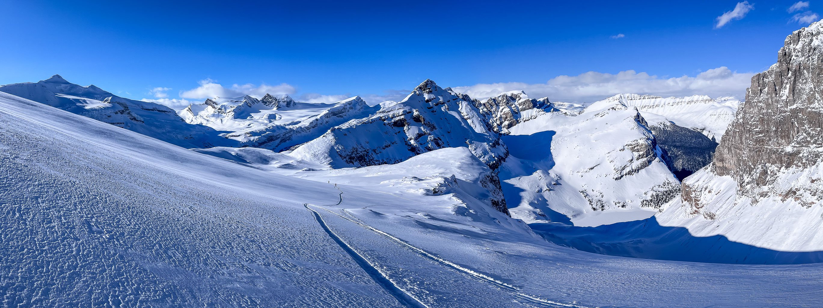
After the excitement of navigating the canyon choke we found ourselves traveling through a winter wonderland. Blue ice clung to the rocky cliffs on either side of a wind-sculpted ribbon of soft blindingly white snow. Blue skies and brilliant sunshine reflected countless crystals of frozen water as our skies carved a neat track over top of them. Sometimes I wonder how I got so lucky to enjoy such pristine and clear moments of living while so many countless others don’t even get a few days of such bliss, nevermind a lifetime of great memories.


Travel up the canyon progressed quickly and soon we were at a split in the route. Access to the Balfour Glacier went right (west) and our planned route to moraines east of the glacier went up to the left. Thankfully there was plenty of snow covering most of the hidden sharks and as we ascended a bench along the moraines we got clear views over the Balfour Glacier to Lilliput Mountain and back to Mount Balfour.

After ascending a few hundred meters along a lower moraine bench it became obvious that we had to transition to the crest of the moraine just east of our track about 10 meters higher. We took the skis off for this short but steep little scramble (typical frozen moraine BS) before topping out on the crest of a long moraine snaking its way up.


After setting a nice, steep track along the moraine crest we finally got our first views of Hector Lake Peak. It looked very snowy but doable and the stoke levels increased a bit. I was nervous for our first views of The Preacher and when we finally got them my feelings of minor apprehension were justified. Almost instantly I spotted what was likely our line up a shallow SW ridge on the west face but it looked fairly steep, fairly snowy in spots and what looked like frozen scree on the upper sections. Arg. Nothing is ever easy when you’re out climbing obscure peaks! I could certainly see why Alex and his team didn’t go for this peak just from seeing it. If I wasn’t aware of a rumored 3rd class route I would have turned back from it myself and just ascended Hector Lake Peak instead. For some reason both Sara and Wietse decided the peak looked very doable and we all quickly agreed that despite HLP being close and relatively straightforward we should definitely tackle our prime objective first.

As with everything else around Hector Lake, The Preacher wasn’t quite as close or even “straightforward” as some of us might have initially thought. We started off towards the distant col, just east of the Waputik Glacier, roughly following the route that Alex and his team used to access the upper reaches of the Balfour Glacier. Initially we had hoped to traverse slopes directly to the col but soon it became obvious that glacial recession had rendered that route impossibly steep and cliffed out. We would have to follow my planned route line up the north end of the dying Waputik Glacier before finding a descent route back down to the Preacher col. It was obvious that our route would end up being fairly exposed down to the east as we neared a shoulder above the col but we really didn’t have much choice at this point. Wietse broke trail along the increasingly steep north slopes until we were glancing somewhat nervously down to the left and crossing mental fingers that the slope was as solid as it felt and the avy forecast predicted it should be.

I was relieved to step off the traverse onto the shoulder. Then I gave the mountain I close look and wondered again if everything would go as planned. My planned route line was up a south aspect but that was obviously not going to work for us. The south gullies were horribly steep and rocky, loaded with snow and obviously dangerous under the conditions we had. The SW shallow ridge that we’d been eying up for the past hour or so was our only shot. The upper 2/3 looked doable but the bottom 1/3 had some steep snow to deal with and was obviously exposed to the full strength of a late winter sun. I was glad for the cool temperatures! But how to get down to the col? We tried to walk down on boots but backed rapidly off a very steep snow slope, not trusting it. We reluctantly chose the lesser of two evils, descending a steep, south facing slope off the shoulder down the col. The slope was exposed to cornices and was cooking in the sun but it would be in shadow by the time we had to ascend it making us more comfortable with the hazards.

From the col the SW route looked quite reasonable. I suggested crampons for the lower 1/3 of the route and almost instantly this choice was justified as Sara led the way up steep snow with some tricky little traverses. I wished I had my ax out for some of the lower route. I reminded the team of my experience on Mount Forbes in 2016 where two members of my team were caught in a relatively tiny slough that almost took us all completely off the mountain!

It was truly shocking how such a small event knocked us off our feet and out of control in the blink of an eye. The snow slopes we crossed were “small” – but definitely large enough to cause damage if they slid out from under our feet. Sara wasn’t impressed with her incredibly sharp crampons which promptly put a couple of holes in her ski pants. You gotta love all that sharp metal in ski boots on rocks and thin snow.


Sara continued to lead up a snow gully before the crampons were no longer necessary. The upper 2/3rds of the face were surprisingly solid rocks and small boulders – much easier than Chesmill a month or so earlier had been. It was a great feeling to finally top out on The Preacher almost 8 hours after leaving hwy 93. Phew! Considering that we round-tripped Chapel Peak in less than 8 hours with similar distance and elevation stats, this is a clear indication of how much more difficult this peak was for us. Fresh snow, slow travel conditions and switching gear all contributed to a much slower pace.


Despite all the extra work it sure felt great to be taking in the wonderful views in every direction. We knew already for the past few hours that we would not be tackling steep snow slopes off the Waputik Glacier to try any sort of traverse to Pulpit Peak. In less snow or different conditions this traverse might work but not for us on this particular day. Even the possibility of adding Hector Lake Peak was starting to feel a little pointless since our current vantage was over 100 meters higher with perfect views in all directions.


The wind was light but cool at the summit and after 15 minutes or so we were ready to descend back to the warmer col for an afternoon snack. With a few last glances at the incredible summit panorama we started the stumble and slide down the upper SW face in our clunky ski mountaineering boots. We put crampons back on for the lower 1/3 and this time I took out my ax as well. The added security in case of a slide or slip was appreciated and soon we were back at the col, thankful that our return ascent route was in deep shadow. After a quick bite to eat we were back on the snow sticks, ascending steeply to the shoulder overlooking the col.

Another sigh of relief atop the shoulder and we were ready to finally take the skins off and do some actual skiing. We’d been discussing Hector Lake Peak since before the summit of Preacher and it was becoming obvious that the team wasn’t feeling it anymore.


I was probably the most keen to do it but to be fair, Sara had broken trail up Preacher and Wietse was spent mentally and physically even before the damn trip so we were all doing fairly good just to make it this far! With shadows growing longer by the minute we already knew we’d be exiting to the road in the dark and it was rapidly cooling off.
I told the others that I was more than fine giving Turquoise (Hector Lake) Peak a miss on our way past it. On the one hand it was the lower peak and would have had similar or worse views anyway (clouds were building at this point too). Now we also would have the excuse to come back in a few years and replicate Alex’s trip – once the painful memories faded a bit. (Update April 2022: Sara and I came back and skied Turquoise Peak only a matter of weeks later in perfect spring conditions.) We had another little break with great views and I enjoyed the last of my food and water before continuing our exit.


On hindsight we likely should have transitioned to the Balfour Glacier at this point for some better skiing but we were tired and just following our tracks back at this point. Despite the odd hidden shark attack on our ski bases the ski back down to the choke at the canyon exit was pretty darn fun. It was WAY too short considering the amount of effort involved but this ski tour was never going to be about the actually skiing. This was a peakbag with skis as the essential tool to get us to the base of our objective. We all managed to ski down the steep choke and out of the mouth of the access canyon without incident. From there it was time to get set for the interminable slog across Hector Lake.

And what a f’ing slog it was! Holy buzzoly. Cripes on a cracker. Hot damn. How in the heck do I manage to forget the feelings of despair, misery and plain physical suffering involved in these lengthy ski tours across the frozen middle of f’ing nowhere in 30cm of fresh snow?! I must have a busted brain or something. Any normal humanoid would maybe try it once and thenceforth swear it off for the rest of their life but not me. For some unknown and unfathomable reason I continue to come back again and again to the same threshold of pain and misery. And I keep thinking, “it won’t be that bad”. And yet, it’s always that bad – or even worse! Afterwards I always wonder if there will be another time and somehow, somewhere, there always is.

I cannot stress hard enough how much misery there is in a late day crossing of Hector Lake after a full day of ski touring and breaking trail. I’ve now done this slog three times and every time I am surprised at where the mind goes in these situations. First it’s not horrible. You’re happy with the summit, you’re happy with the gorgeous scenery and you’re happy to be alive. Then you finally reach the lake and think, “it’s not that far”. Then an hour later you think, “have I even started across this damn thing yet?!”. An hour later and your body is hurting everywhere – and I mean in places you thought you’d numbed out years ago. Of course in the end all of the pain and suffering are 100% voluntary and for selfish reasons but I’m not sure if that makes it better or worse? I must admit that I do enjoy pushing my mind and body to the edge. There’s a strange energy lurking at the edge of human endurance and the only way to experience it is to get there and the only way to get there is to suffer your way over to it. I’ve only managed to push myself to this place at the edge of conscious, controllable thought a few times in the mountains but it’s always left an impression that the trip was worth every moment of the suffering it demanded.


It’s very interesting to me that we still beat my time from BowCrow Peak by 1.5 hours but were 4.5 hours slower than our time on Chapel Peak despite both of those having similar stats. I guess conditions and conditioning really do make all the difference between a speedy round trip time and a longer day. The Preacher may not be the tallest, the most prominent or the most challenging peak in the world but it’ll always stand out in my memory as one of the good ones. Thanks to Sara and Wietse for greatly assisting me in making this one happen. Without their physical and mental energy I would have tucked tail and ran long before reaching any summit on this particular winter day in the Rockies.
Fabulous photos and nice long trip Vern. I miss those late winter-early spring skiing trips on the Wapta Icefield, Columbia Icefield and many more. Did quite a few of them back in the 90’s.
Thx. Yeah I’m running low on these peaks myself. Looking for the obscure ones now! 😏
You’ve done so many. I bet it’s quite a challenge to find new ones!
Harder each year. 🤷🏼