Summit Elevation (m): 3148
Trip Date: September 25 2015
Elevation Gain (m): 2800
Round Trip Time (hr): 2 days
Total Trip Distance (km): 54
Quick ‘n Dirty Rating: Class 3 – you fall, you break your leg
Difficulty Notes: A remote peak with a river crossing and some steep snow or loose rock slopes to access the false summit. No other major difficulties.
Technical Rating: SC6; YDS (3rd)
GPS Track: Gaia
Map: what3words
By the end of September 2015 I was getting a wee bit desperate to finally see some fully turned larches. Despite getting out a lot in the middle of the month, especially to Waterton Lakes National Park, I’d yet to run into the full fall golden goodness of larch heaven that I’ve come to crave at the end of each scrambling / hiking season in the Alberta Rockies. As usual for the 2015 season, the weather did not cooperate when I needed it to! The forecast for the weekend of September 25-27 was looking a bit thin. Sunday was the best looking day by far, but as the dates crept closer the forecast grew dimmer until even Sunday was looking like a good shot at cold, cloud and possibly rain or even snow. Friday was downright dismal with showers and Saturday was a crap shoot with one small weather window opening up mid day but pretty cloudy around that window. There is one guy I know who thinks this is a fantastic forecast. Phil Richards originally hails from the UK and is very used to cloudy, cool, damp (i.e. miserable) hiking. He still thinks this is perfect weather for a stroll. As long as it’s not horizontal rain, he’s good to go! So I emailed him for his availability and after a few questions (how remote? how wet? how long? how many previous ascents?) he was in. Incidentally, for a rarely ascended peak there is pretty good beta available for Mount Drummond. Rick Collier, Graeme Pole and Steven Song all have reports that are useful despite the fact that we were only the 8th signees in the register over the past 21 years.
We decided to save ourselves almost 8 km of walking up and down the Temple Lodge road by riding bikes on this section. Phil met me at the Skoki Lodge parking lot and after gearing up we set off up the road in a light drizzle. I’ll admit that part of me was pretty skeptical of our plans after driving through both Canmore and Banff in warm sunshine only to plunge into the heart of darkness near Lake Louise! Thankfully the rain was pretty light at this point. The bike ride up the road was a lot quicker than I expected. Sure – there’s a few steep sections that required us to push our mighty steeds rather than ride them, but for the most part I managed to use granny gear and grunt my way uphill. We passed a road repair crew who seemed impressed with our efforts. Unfortunately for us they were in a steep area so we had to walk past them rather than the much cooler option of riding.
At the end of the road we managed to find a nice hiding spot for our bikes behind a shed. Still under a grey sky and light drizzle we set off up the trail towards Boulder Pass. I didn’t even have my camera out, which is an indication of the conditions. Right off the bat I was surprised at the conditions of the hiking trail – it was absolutely demolished by horse traffic. I didn’t think there was that many horses allowed on this trail, but all indications pointed towards a fairly large herd. On our bike ride up we’d passed a corral with at least 10-15 horses in it and on hindsight we realized that these horses were recently herded down the trail from their pasture near Red Deer Lakes to be wintered somewhere lower down. I understand why this happened but it was horrible timing for anyone going into the Skoki area for larch viewing! It was horrible timing to march hooves over a rain/snow soaked trail too – the damage was exacerbated greatly by the soggy conditions.
Interesting Facts on Mount Drummond
Named by George M. Dawson in 1884. Drummond, Thomas (The assistant naturalist to Franklin’s Second Arctic Expedition. He spent the winter of 1825-26 in the Athabasca River valley.) Official name. First ascended in 1947 by Elizabeth Rummel and party. Journal reference CAJ 19-41.
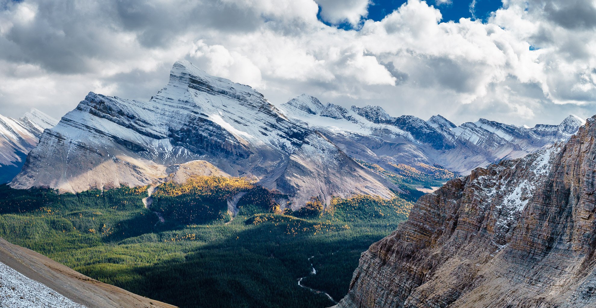
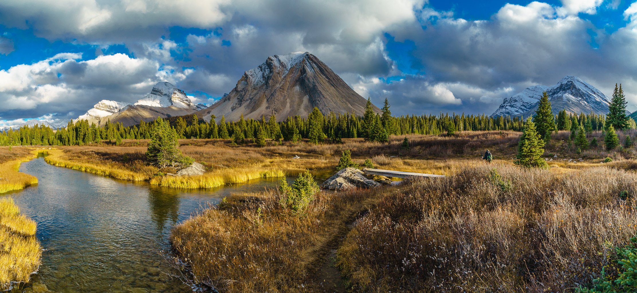
Phil had his grizzly senses tuned way up and managed to spot a huge bruin about 1km away, stuffing his face on the Lake Louise ski runs across the valley from us. It was a good way to start our hike and we kept seeing bears everywhere until that became old (all subsequent sightings were NOT bears, unfortunately). As usual when backpacking or hiking with Phil, we made great time to Boulder Pass. My last non-skiing outing to the Skoki area was a decade ago, way back in 2005 when I managed to bag all the Kane scrambles in the area in a 72 hour peak bagging blitz with my cousin Jon and brother Rod. Even though I’m 10 years older now, I didn’t really feel it thanks to a pretty intense peak bagging season already behind me this year. (Hopefully I feel the same way in another 10 years…) As we hiked up Boulder Pass we could tell that the larches were in a state of absolute perfection. The rain was saturating them, making them look like they were on fire. The best part was that my camera was in my pack, thanks to the rain!
As we crested Boulder Pass, the great view of Ptarmigan Lake with Redoubt looming over it presented itself. Phil had so far avoided the Skoki area (too popular for his tastes) but even he had to admit that it was looking pretty darn sweet at this point. We slipped and slid our way along the trashed trail towards Deception Pass. By this time our boots and pants were covered in slimy much and horse poo. Good thing the views were still decent or we might have become a bit miserable at this point. Instead we humored ourselves with discussions ranging from the scientific to the historic to the mundane – anything to avoid thinking too much about the rain, horse poo and muck.

Our plan was to approach the Red Deer Lakes campground via Deception Pass and the Red Deer Lakes hiking trail going between Skoki and Fossil peaks on Friday afternoon / evening. On Saturday we’d take the Red Deer River trail to Shingle Flats and ascend Mount Drummond, despite some warnings that this could be a bigger day than we were counting on (read the comment below the trip report). On Sunday we wanted to take the Packers Pass exit trail, hopefully taking a larch-filled excursion through Myosotis and Zigadenus Lakes. Back in 2005 I remember taking the trail between Fossil and Skoki and thinking it was fairly long. This time it wasn’t. I think my sense of what a “long trail” is, has been tweaked a bit in the decade since peak bagging was a fairly new sport in my world.

Despite the horse poo, slick muck, rain and generally miserable conditions, the hiking was still very enjoyable for me. The larches were brilliant. The smell of fall was thick in the damp air. The air was cool. We were alone from Deception Pass onward. The peaks were wreathed in cloud and snow, making them seem larger and more distant. The streams were cold, clear and refreshing. Let me put is this way – it was a helluva lot more enjoyable than sitting at work, in my warm, dry cubicle back in Calgary would have been!

Around 5 hours after leaving the parking lot we stumbled and slid into camp. The Red Deer Lakes camp site is fairly rustic but we managed to find a great tent spot under several large trees that slowed the rain a bit. The camp was empty – not a surprise for late September in a cold drizzle. We made supper and turned in to read our books at the early hour of 20:00. The rain continued all through the night and when we finally decided to leave the tent at 07:00 it was still coming down lightly. The mountains that we could see from camp were covered in fresh snow. I was not feeling that positive at first – but of course we both covered up our doubts with confident statements about bagging the peak despite the dismal weather. As if to spite us, the rain turned to snow just before we left camp for Drummond.
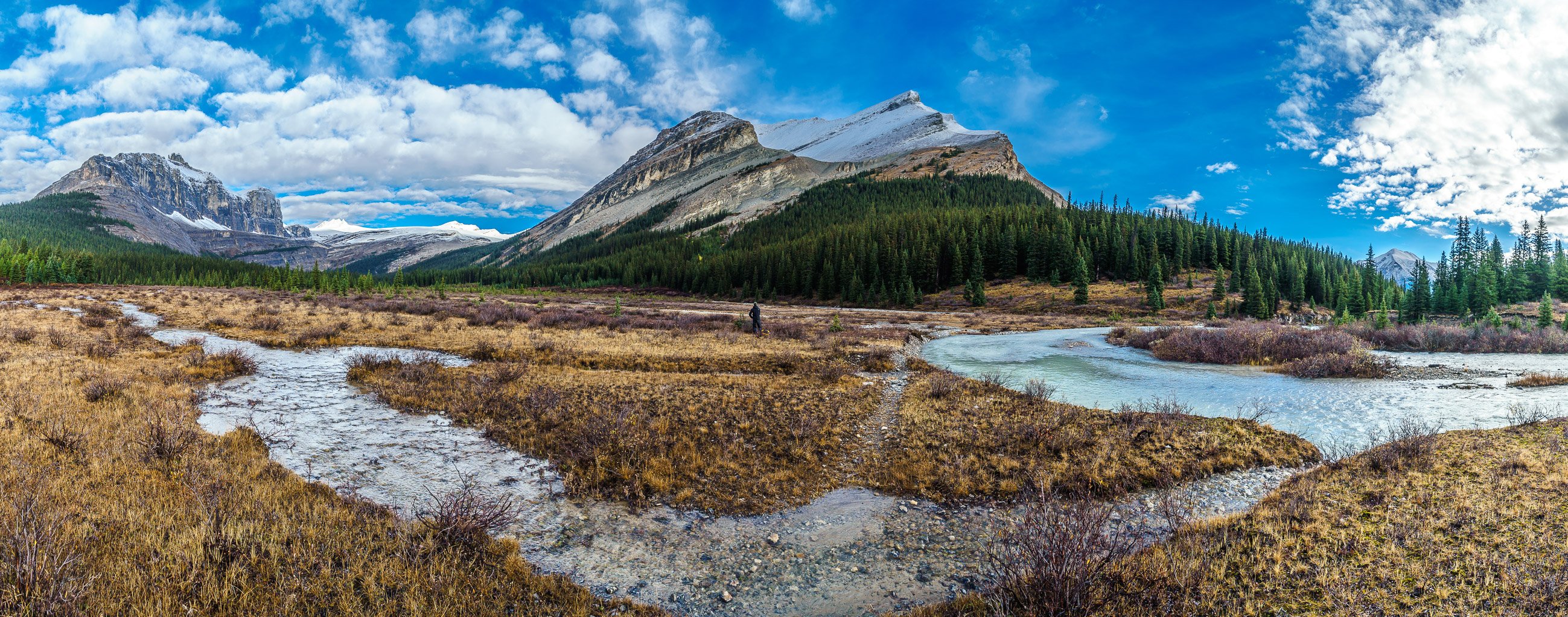
The trail was, as expected, completely trashed from the recent moisture and horse traffic as we followed it towards the Red Deer River and through the warden camp / horse corral. There was some nice trail infrastructure in the form of a few bridges crossing the river, but all that nice work was undone by the terrible conditions of the trail itself. I still don’t know where all that MUD comes from – isn’t this supposed to be the ROCKY mountains?! On a more positive note, the weather started to improve as we hiked through the forest along the Red Deer River. The trail is quite nice from the horse corral to Shingle Flats but there are limited views. By the time we were down to the flats (key word: down), there were blue patches of sky overhead – things were definitely looking up. Thanks to all the moisture Drummond Creek, running down from the Drummond Icefield was too high to easily cross. We spent about 30 minutes trying somewhat successfully to drag and place a log across the torrent so we could get across. Thank goodness we didn’t have to cross the raging Red Deer River at this point! Apparently this stream is usually one of the main obstacles to ascending Drummond so be aware that earlier in the season it could be a significant challenge.
Once across Drummond Creek we weren’t 100% sure which gully to ascend. I had a way point marked on my GPS but looking at that area now, all I saw was a series of cliffs. We decided it had to be the only obvious gully and headed for it. After only 2 minutes of bushwhacking we found ourselves in a nice drainage with a complex series of moraines high above us – hopefully giving us access to the huge upper gully and false summit. As we ascended the steep moraines we realized that all the rain and snow had significantly softened the terrain, making it easier to ascend the scree / dirt.


The clearing weather and good scrambling conditions gave us energy and soon we were in the giant upper bowl that leads to Drummond’s false summit. As Steven indicates in his trip report, beware of the extreme foreshortening that this bowl presents! We knew about this issue and still managed to under estimate it! Phil and I took turns kicking steps up the steep slope at the back of the bowl (Ok, Phil did most of it…) which helped considerably on the loose terrain. Our views of Mount Douglas rising steeply behind along with larches and small tarns dotting the landscape distracted us from the suffering.


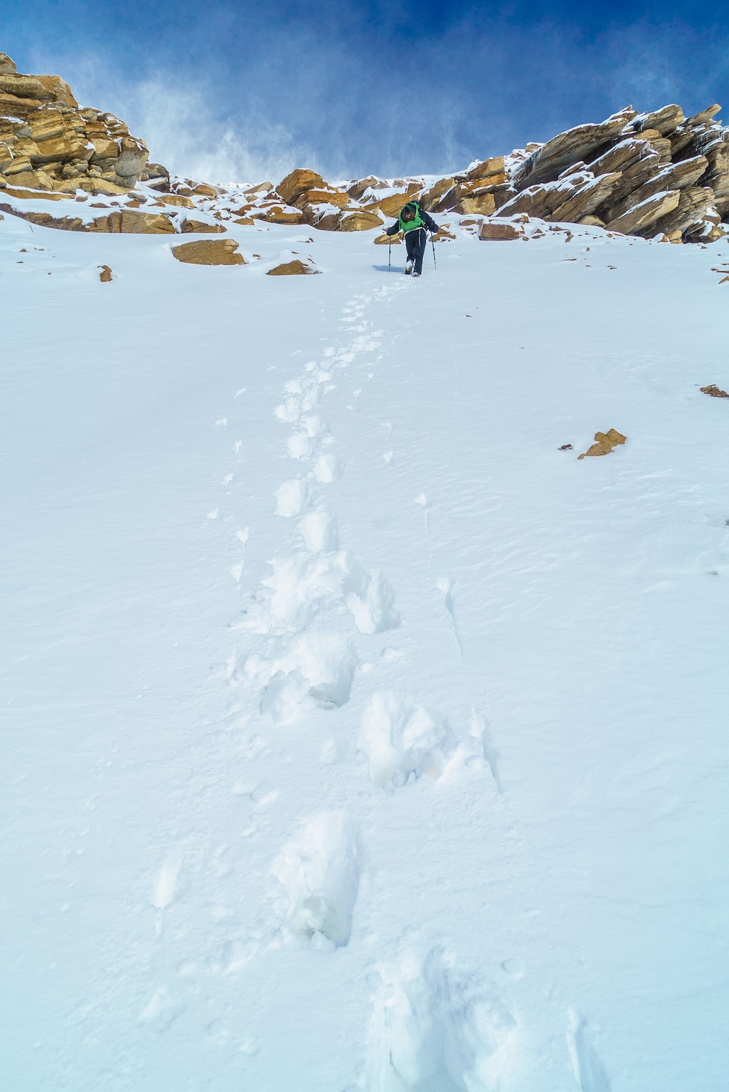
As we gained height towards the false summit we were pummeled by strong winds and corresponding blowing snow. The fresh snow that had fallen over night was creating blizzard-like conditions about 1-2 feet above the surface and occasionally whipping into our exposed faces. Interestingly, the air temperature wasn’t that cold, but the conditions looked horrible. We kept going, hoping that once we topped out on the upper ridge conditions would improve. Thankfully this is exactly what happened. Phil was demoralized by the view of the true summit from the false one, he admitted to me later. I was expecting far worse than what I saw, so my spirits were lifted instead.


I led the way down to the col and started kicking steps up the lower, steep, final summit slope. On hindsight I should have contoured further around to climber’s left to avoid any technical terrain, but I simply kicked steps straight up it. Phil took over eventually and the wind helped blow us up to the summit cairn. It took me some digging to find the register and when I finally cracked it open, we were only the 8th summit party since the register was placed by Rick Collier in 1994 and the first since 2013 when Steven and Eric summitted.
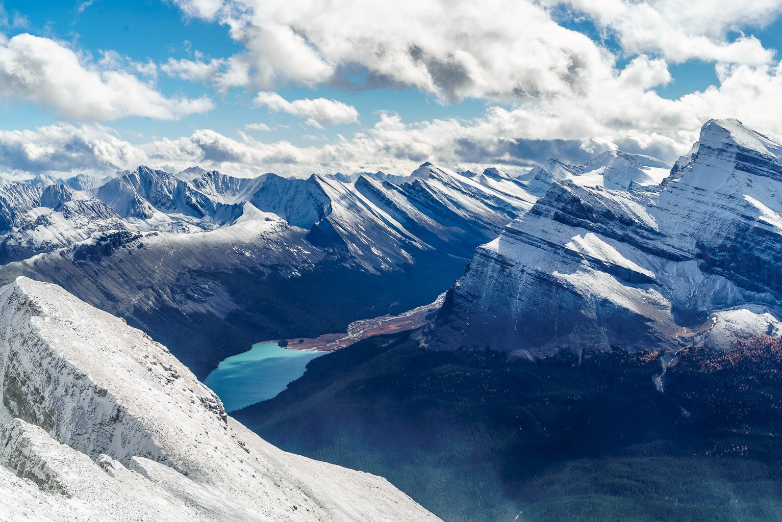
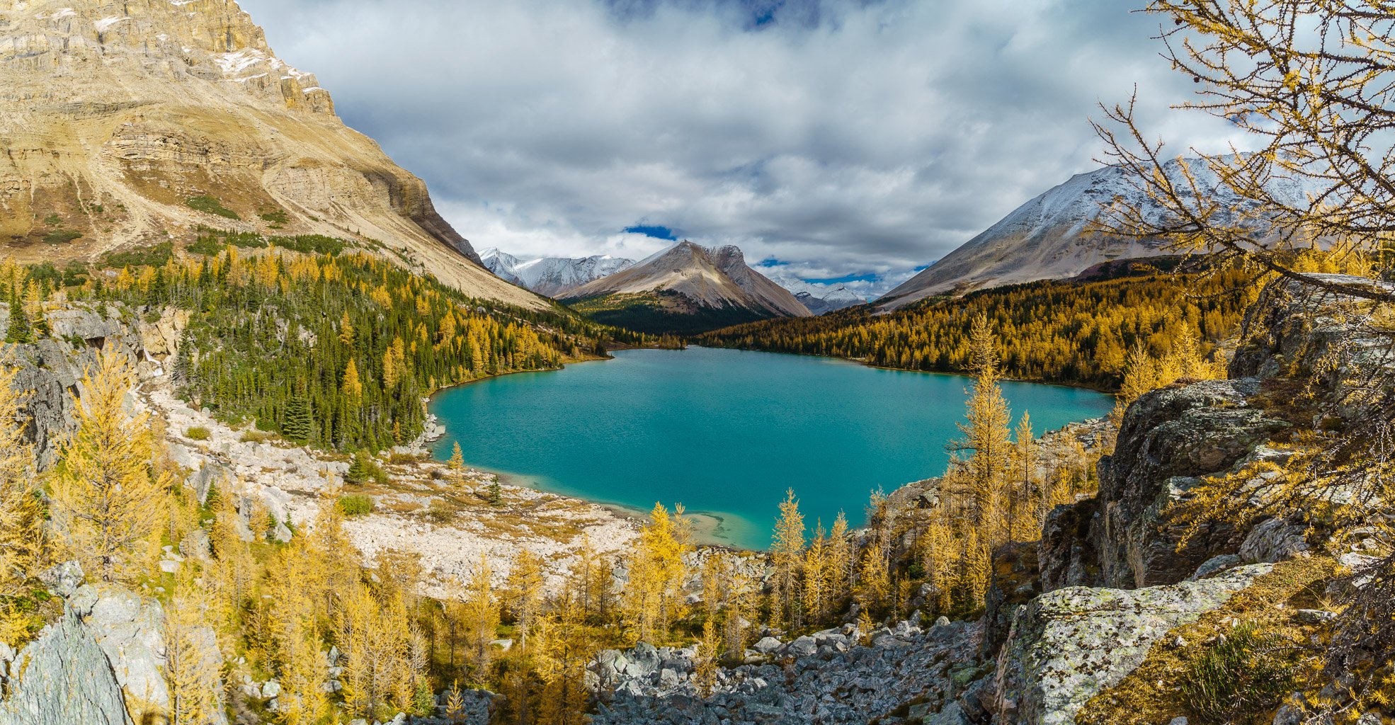
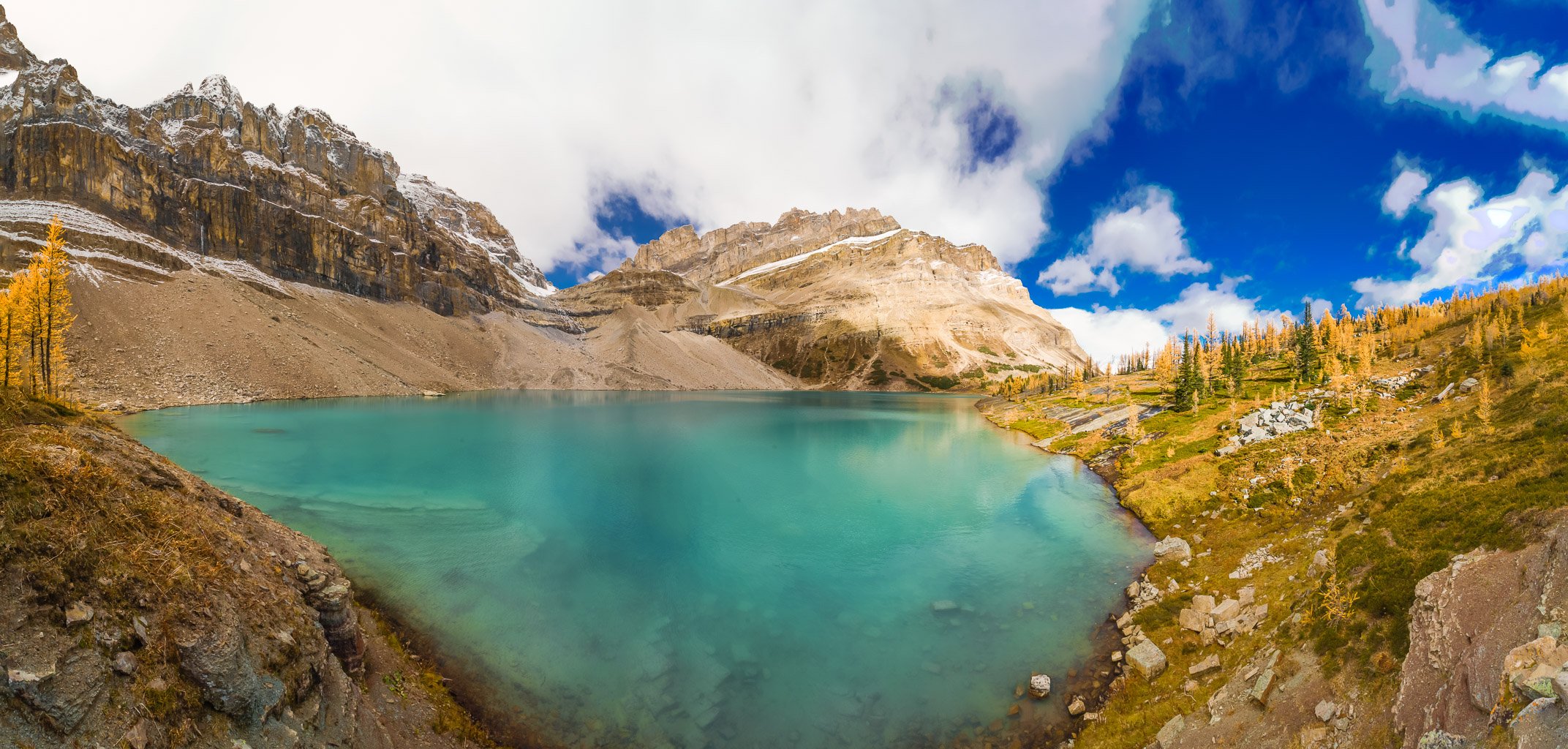
The views from the summit were muted a bit by all the snow being blown about, but they were my favorite kind of summit views nonetheless. I’ve had so many bluebird days on summits, I’m kind of bored with the same view of endless series of peaks with no ‘attitude’. The blowing snow, low cloud and the energy that all this action imparted to the landscape was perfect. Our views towards Mount Douglas, Cyclone and Pipestone were amazing. Mount Hector and Balfour even showed up to the west. We could spot many of the lakes along the various creeks and rivers below, including some of the Red Deer lakes, part of Douglas Lake and even the iceberg dotted Drummond Lake from the summit ridge. Despite our toes being frozen, we were feeling pretty darn good about the whole experience as we signed the register and started the long journey back to our camp.


The descent was very quick. Drummond is a rare mountain where the ascent slopes are soft – making ascent easy (kick steps) and descent fast (run down). I’m not sure if we just got lucky with the wet conditions or whether this is always the case, but we took full advantage. Even the moraines were soft which is certainly not normal. We got lucky again with our temporary log crossing at Drummond Creek. Despite the wet weather, the cool, overcast conditions prevented the creek from rising too much over the day and we managed to reuse the log – only getting a little wet in the process.
The trudge back up (key word: UP) the trail to the Red Deer Lakes camp was fairly long, but straight forward. Our round trip time of 10 hours was fairly quick considering the distance, conditions and height gain. The temperature began dropping precipitously as we prepared supper. After shivering our food down, we once again retired to the warmth of our sleeping bags early. Thank goodness I brought my e-reader on this trip. Sunday morning dawned fairly clear and very chilly.


Packers Pass Peak (Skoki Lakes)
Our exit the next day included some pretty sweet weather and views compared to the ascent day. We checked out the Upper Red Deer Lake before setting off for the Skoki Lakes – Myosotis and Zigadenus via an excellent and surprising trail from the Skoki Lodge area. The brilliant colors of the lakes and larches surrounding them is something I won’t soon forget. We also ascended the minor summit next to Packers Pass, creatively dubbing it “Packers Pass Peak”.


Just incredibly beautiful. My wife and I did a 3 night 4 day trip into Red Deer Lakes Campground from Lake Louise this past August. (We’re from New York) Next year i’d love to up the amount of days, perhaps in at Mosquito Creek, over to Douglas Lake and out at Lake Louise. Would love to do easy peaks but the scenery is so epic from any elevation and my wife probably won’t hike up the mountains!
Was fun “cheating” and grabbing an incredible snack, coffee and beers at the Skoki Lodge…maybe next year we’ll try to pass through there twice on our itinerary!
That sounds like a great trip!
We saw your entry in the register when our group went last year en route to Drummond Glacier! The larches were also in their prime — what a special place!
Yes, this is a gorgeous spot in the fall for sure.