
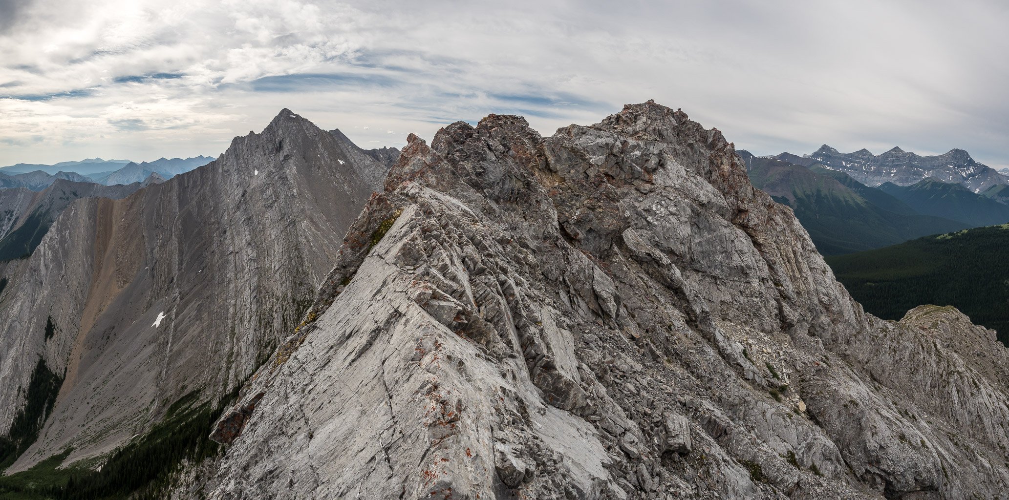
From the summit of South Totem Peak, Spreading Peak looked pretty darn sweet. I remembered looking up at Spreading Peak from our long traverse towards Marmota Peak in 2015 and thinking the same thing. A beautiful line of snow highlights the ridge to the summit cap and it looked pretty easy to boot. The issue – as with any peaks in this part of the Siffleur Wilderness – is access. There is no quick or easy way to access the gorgeous summits in this area. Or is there?

After a very successful and somewhat tiring 5 day trip with my daughter in which we traveled approximately 57km and over 4500m of height gain, I was ready to put my feet up for the remainder of my week off. Then Phil texted me… When Phil sends a text, it’s usually some idea for an exhausting day trip involving many kilometers and many hundreds of meters of height gain, usually on an objective that nobody has ever heard of. Needless to say, I wasn’t surprised when we settled on a day trip of South Totem and Spreading Peak in the Murchison Group just east of Totem Creek in Banff National Park.

After spending a glorious day at the Lake of the Horns, KC and I awoke to yet another day of brilliant sunshine on the last day of our 5 day backpacking trip along the southern Highwood peaks on the Great Divide. Our plans for the day would be to take my slightly easier alternate descent down the Lake of the Horns headwall before picking up a horse outfitters trail that was rumored to circle towards our last peak of the trip – The Hill of the Flowers.

After a few intense days of backpacking and scrambling five summits, Kaycie and I were ready for a relaxing day by a gorgeous and remote backcountry lake. So that’s exactly what we did. When doing research for our trip, I’d relied heavily on Matt Clay’s August, 2015 trip where he and Sandra backpacked into Weary Creek Gap before traversing up and over Mount Muir before being turned back at the Carnarvon Lake chains. I had changed things up, based on his experience, choosing to ascend, rather than descend the chains. Since our original plans called for a much longer trip, I was keen to extend ours by at least a day and came up with an intriguing option to spend a day and night camping at Lake of the Horns (LOTH) from our Weary Creek headwall bivy.

I really enjoyed Mount McPhail and the Weary Creek Gap area. This area certainly deserves the attention of any Alberta Rockies peakbagger or backpacker.

After a nice, relaxing day spent ascending Mount Strachan before chilling at Carnarvon Lake, Kaycie and I woke up early on Monday morning to tackle Mount Muir and our highline traverse to Weary Creek Gap. The idea for this traverse came from a thread that Matt Clay started on ClubTread and from some further research into a longer backpack in the area known as the “Elk Highline”. The basic idea was to take full backpacks up and over Mount Muir and down towards Weary Creek Gap which would be our home for another night and possibly a base camp for an ascent of nearby Mount McPhail.


While I can heartily recommend Mount MacLaren as a short(ish) scramble from Carnarvon Lake, I can’t really say the same thing about Mount Shankland.

The summit views were pretty sweet from MacLaren, including many of the Kananaskis peaks I’ve stood on like Holy Cross, Head, Gunnery and even all the way to the Highwood Pass with lofty summits like Rae and Mist showing up.

After dreaming of visiting this area for many years, I have to say that it still exceeded my expectations.

On Wed or Thu the usual flurry of emails went out regarding plans for the weekend. When the dust settled, Phil Richards and I were left choosing between two lengthy day trips. In the end, Watermelon Peak won out. Most people do Watermelon as part of an overnight bivy at Lake Alice, and while this is a wonderful way to experience this peak and this lovely area, we simply didn’t have the schedule to allow it this time. It was while we were poking around at the route and planning the trip that Phil wryly texted me – “you realize that Bobac is also in the area”.

Summit Elevation (m): 3088Trip Date: July 15 2017Elevation Gain (m): 1650Round Trip Time (hr): 14.5Total Trip Distance (km): 28Quick ‘n Dirty Rating: Class 3/4 – you fall, you break your leg or possibly dieDifficulty Notes: The south ridge route that we took involves difficult, loose scrambling with exposure. There are easier routes but they are longer and cannot be done safely with the amount of snow they had when we were there.Technical Rating: SC7; RE4GPS Track: GaiaMap: Google Maps After spending an amazing morning approaching and […]
Summit Elevation (m): 2454Trip Date: July 08 2017Elevation Gain (m): 1600Round Trip Time (hr): 7Total Trip Distance (km): 13Quick ‘n Dirty Rating: Class 4 – you fall, you are almost deadDifficulty Notes: Routefinding is key to keeping this scramble reasonable on approach. The final ridge to the summit is difficult, loose and exposed scrambling but pretty short.Technical Rating: SC7; YDS (4th)GPS Track: GaiaMap: Google Maps After enjoying a Kane difficult scramble on Divide Mountain with Liz and Mike on Friday, I choose to go solo on a Nugara difficult […]

Summit Elevation (m): 2409Trip Date: July 07 2017Elevation Gain (m): 1200Round Trip Time (hr): 8Total Trip Distance (km): 15Quick ‘n Dirty Rating: Class 4 – you fall, you are almost deadDifficulty Notes: Named in 1998. The mountain is situated on the Continental Divide. Official name. (from peakfinder.com) NOTE: The height listed as 9400 feet is much too high for this peak which is closer to 7900 feet high.Technical Rating: SC7; YDS (4th)GPS Track: GaiaMap: what3words On Friday, July 7 2017 I finally managed to get out with a […]

After an easy day on Mount Stelfox, Mike Mitchell and I were pretty excited to find a scramble route up it’s higher northern neighbor – Bright Star Peak. As far as we knew there are no recorded scramble ascents of this peak – as a matter of fact, I don’t know of any online trip reports of anyone getting to the summit although I’m sure some folks have, over the years. As it turns out, there is good reasons for the lack of beta on this peak. We got up early at our bivy along Whitegoat Creek and by 05:00 we were on the familiar approach trail towards Whitegoat Pass. Why bother redoing this trail and not bivy higher? Simple. There’s no easily available water anywhere from Whitegoat Creek to the Pass, or even beyond.

When our plans for climbing Mount Lefroy fell through, Mike and I started looking at other options. After swearing that I was done with David Thompson Country for at least a few months, I found myself planning another trip to the area. Mike was still feeling ill on Saturday, so I solo scrambled Abraham Mountain – a delightful and unexpectedly short day out. Our plans for the Sunday and Monday were to scramble Mount Stelfox, spend Sunday night camping and then attempt to find a scramble route up Bright Star Peak, it’s higher neighbor to the north.

Abraham Mountain was much more enjoyable and pleasant than I expected. It’s moved up to my favorite scramble in the David Thompson corridor for now. It has all the elements that make a scramble worthwhile IMHO. Intricate routefinding that makes a huge difference in the difficulty and total times for the trip. Varied terrain such as gullies, light forest, cliffs and snow. Gorgeous views all day and especially from the summit. No approach and a feeling of remoteness even though it’s only a few kilometers from a busy highway. I highly recommend this scramble.

I had lots of time the afternoon before, after successfully scrambling Whirlpool Ridge, to think about objectives for my third and final day in DTC. I really wanted to try some of the Ex Coelis group but wasn’t sure I was in the mood for solo difficult scrambling. I also wasn’t sure about the weather fx, since I didn’t have cell reception. I finally settled on trying Elliott and Sentinel which interested me after talking to Mike about his trip in August of 2015. There were no published scramble routes up Elliott before Raf and Andrew finally found one on their descent of the mountain in August of 2011 after a very long and difficult ‘scramble’ up a slabby gully on it’s west face.

After coming so close to its summit the day before after a traverse from Tuff Puff, I knew I was coming back immediately to make a second attempt at Whirlpool Ridge’s highest summit the very next day. I enjoyed a delightful (free) camp along hwy 11 the evening before, setting up my mid on the back of my truck for the first time, which worked out great. The only fly in the ointment was repeated gunfire nearby, throughout the evening which kept me up until around 11pm when darkness finally started settling in! The joys of camping outside of a park I suppose.

Summit Elevation (m): 2800Trip Date: June 17 2017Elevation Gain (m): 1700Round Trip Time (hr): 10Total Trip Distance (km): 14Quick ‘n Dirty Rating: Class 2 – you fall, you sprain somethingDifficulty Notes: No difficulties to the summit of Tuff Puff. Whirly Puff is mostly an off-trail hike if you avoid our ill-advised attempts to Whirlpool. Note: We did an exploratory trip well beyond Tuff Puff to see if we could forge a route up the NE face of Whirlpool Ridge. We couldn’t and we didn’t.Technical […]
After a longish outing on Mount Head a few days previous with a couple of smelly guys (no offense guys), I decided it was time for a nice hike in Waterton Lakes National Park with my wife for a change. She not only looks (a lot) nicer than those other guys, but she smells nicer too. Again – no offense guys. In the fall of 2015 I hiked Lakeview Ridge solo and remember really liking the Horseshoe Basin area.

On Friday, June 09 2017 I managed to summit Mount Head in the Highwood Range of the front range Rockies with Wietse and Kev Papke. Exactly ten years previous, to the day, I scrambled up Mount Head’s southern neighbor, Holy Cross Mountain, also with Wietse. Also, almost ten years to the day, was the first time I became aware of the scrambling on Mount Head when some friends did it and reported back. It was on my radar ever since and just never seemed to get priority until now. This was long before Nugara’s scrambles book added it to yet another list.

There was nothing to do after finally standing on top of Two O’Clock Peak but start our long descent towards Two O’Clock Ridge and the highway, far below and far in the distance still at this point. We were feeling pretty positive as we started down the summit ridge towards the obvious east descent ridge. It looked pretty darn easy and not too far. We should have known better!

In his trip report, Eric mentions that he side-hilled on the east side of Two O’Clock Peak before reaching the far ridge and then backtracking back up to the summit on blocky terrain. He also mentions that it might work better to access the summit directly from the Landslide col. Mike and I were about to find out as we slowly and painfully worked our way down the huge (and freaking loose) boulders and rocks down from the summit of Landslide Peak. As I balanced my way delicately down to the Two O’Clock col, I was hyper-aware of the dangers of a boulder tipping over on either of my legs and doing some serious damage.

We had two choices from the summit of Bridge Peak. Turn back and descend via Ernest Ross or fully commit to our traverse and head southwest towards Landslide Peak. Guess which one we chose? Darn peakbaggers. Mike Mitchell and I figured beforehand already that the most complicated stretch of our planned traverse from Mount Ernest Ross to Two O’Clock Ridge was going to be the descent of the west face of Bridge Peak. We were correct on hindsight.