
Summit Elevation (m): 2739
Trip Date: September 27, 2025
Elevation Gain (m): 1650
Round Trip Time (hr): 9.5
Total Trip Distance (km): 32.5
Quick ‘n Dirty Rating: Class 3 – you fall, you sprain or break something
Difficulty Notes: Trails (human and goat) get you to scrambling terrain and from there your route finding abilities keep things easy to moderate plus.
Technical Rating: SC6
GPS Track: Gaia
Map: Google Maps
Years ago I was bored one winter and spent a month or so going through all of David Jones’ climbers guides, adding all the peaks I thought were (realistically) in my wheelhouse to a spreadsheet of objectives I already had compiled over the years from other sources. From there I gave all the objectives priorities and other sources of data (i.e., previous ascents, trip reports, GPX tracks). I added more columns to the sheet as the years ticked by but in general this reference has been a main source of inspiration. Other people have done similar exercises – I know this because they often are my updated sources of beta as they “beat me to it”. 😉 A good example of this would be Mount Castelnau that Holly and Jake did before I could get to it. No matter – it’s nice to have updated beta and their experience allowed me to do the 50km trip as a one-day outing this past summer.
Mount McCrae has been sitting in my spreadsheet for a while now, and surprisingly, nobody was giving me updated beta on it. I say this is surprising because as far as Dave Jones’ notes from Allan Schierman were concerned, McCrae is only 3rd class and very accessible. There were a few things giving McCrae a high rating in my spreadsheet and the fact that Allan Schierman put up this route was a big one. I like his routes and have used them before with great outcomes. Another point for McCrae was its access and position via Loomis Lake. I’d never been there and was very curious about the area. I was sure there must be a good trail all the way into a stocked lake along the Great Divide. Finally, there promised to be LARCHES involved! YES. After a gorgeous larch march into Lake Merlin a few days previous, I wanted more yellowy adventures. Speaking of “more”, Allan also has two other minor peaks listed in the guide. I didn’t see any reason they couldn’t be combined with McCrae, but especially UN2731 would add significant height gain and loss considering the route went over UN2647 both ways.

Devan Peterson has the ability to do almost every peak in Jones’ guides solo, and he also has the same objectives as I do (and a great deal more). When scrambling Duchesnay with him a few weeks previous, we discussed McCrae and as the weekend drew near he texted me that he was going for it on the 27th. We weren’t sure how much of the approach could be biked, but I knew that we could almost certainly bike up to 4 kms of it. When I’d completed a solo ascent of Mount Bishop in 2020, I’d lamented the fact that I didn’t bring my bike. If you know anything about me, I like to push the limits of what is truly “bikable” or not and was looking forward to the challenge. The evening before the trip, Devan decided Sunday was better for him but I was already locked ‘n loaded and told him I would give him the beta for once.


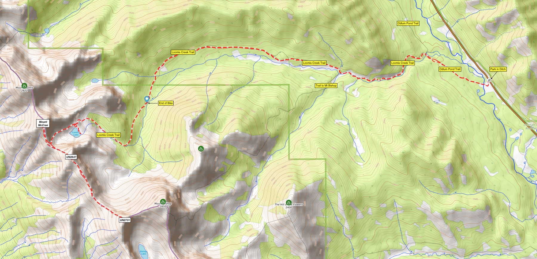
After driving through a dramatic sunrise I continued up Hwy 541 to Hwy 40 and from there to the strange parking area I’d used half a decade earlier for Mount Bishop. I say “strange”, because frankly there must be a better place to access the Loomis Creek Trail. AllTrails has the same access that I used. I haven’t find a better one but I was the only car parked in the ditch and more people were in the area when I was there, so they obviously parked elsewhere. The first section of trail from the crossing of the Highwood River to Loomis Creek is part of the “Odlum Pond Trail”. (I’ve been to Odlum Pond before and was not very impressed.) I managed to lug my bike over the guardrails along Hwy 40 before riding down an old road access to the Highwood River below the hwy. From there I rode through seasonal logging equipment (including a temporary bridge deck) to the river and easily crossed (it was below the knees but freaking cold). From there it was a quick and easy ride along a wide, flat Odlum Pond Trail to my 2nd water crossing of the day at Loomis Creek.


As I pushed and pedaled my way up the rough trail along Loomis Creek from the first crossing, I wondered how far I should bother with the ride but decided to give it at least a few kilometers. Good decision Vern, good decision. Other than the 4 subsequent water crossings (all unbridged) and an annoyingly muddy downhill section, the ride to the Bishop junction went surprisingly well. And from there it only got better! I was pumped to see an obvious road continuing further up the Loomis Creek valley from the Bishop junction. I’ve had this before – riding much further than expected, and it’s always a huge mental boost. There were sections of rough riding for the next 5kms, but nothing too dramatic and certainly nothing I couldn’t handle on my gravel bike. Admittedly, the final 500 meters of riding was probably overdoing things, but that’s usually what happens to me and bike approaches. How else do you know you should stop?


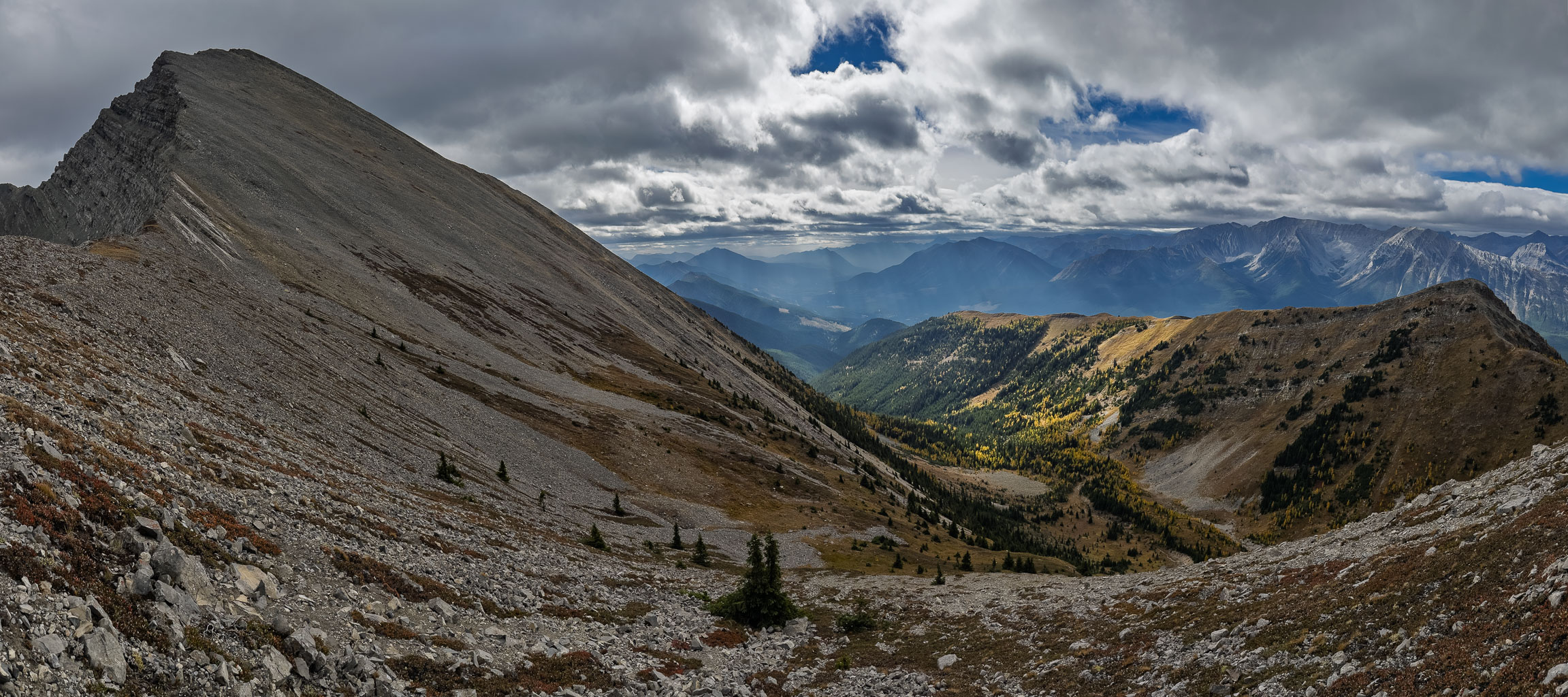
After roughly 75 minutes and 9.3kms of riding, it was time to continue on foot. The trail was muddy and narrow at this point and I was nearing the end of my approach valley. I had no idea what to expect but continued on a narrow trail leading steeply up into surrounding forest. Looking at the topo map, I wondered how much height loss I’d encounter to the lake. I was happy to be on foot as the trail narrowed even more and steepened to a narrowing valley as it turned sharply to the NW towards Loomis Lake. And this is where the magic started in earnest.
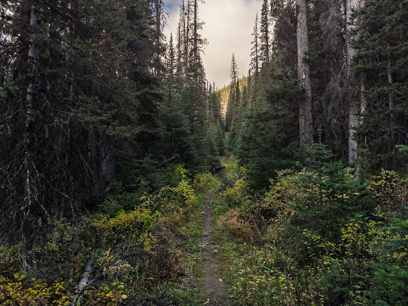


A totally unexpected route wound its way through a narrow valley with a small stream trickling and bubbling its way along it. The trail crossed the creek several times but due to its size, my feet didn’t even get wet as I followed it. Instead of losing height and undulating as I was expecting, the trial kept gaining height towards another surprise – a delightful alpine meadow campsite with protective trees and the promise of larches just ahead.


I followed the trail as it continued to wind its way through tight trees and then ascend steeply through my first larches of the day towards an obvious headwall below the lake. I was delighted with the route so far! Amazing views were opening up behind me as I walked on golden needles through a beautiful little larch forest and up a winding trail through the headwall.


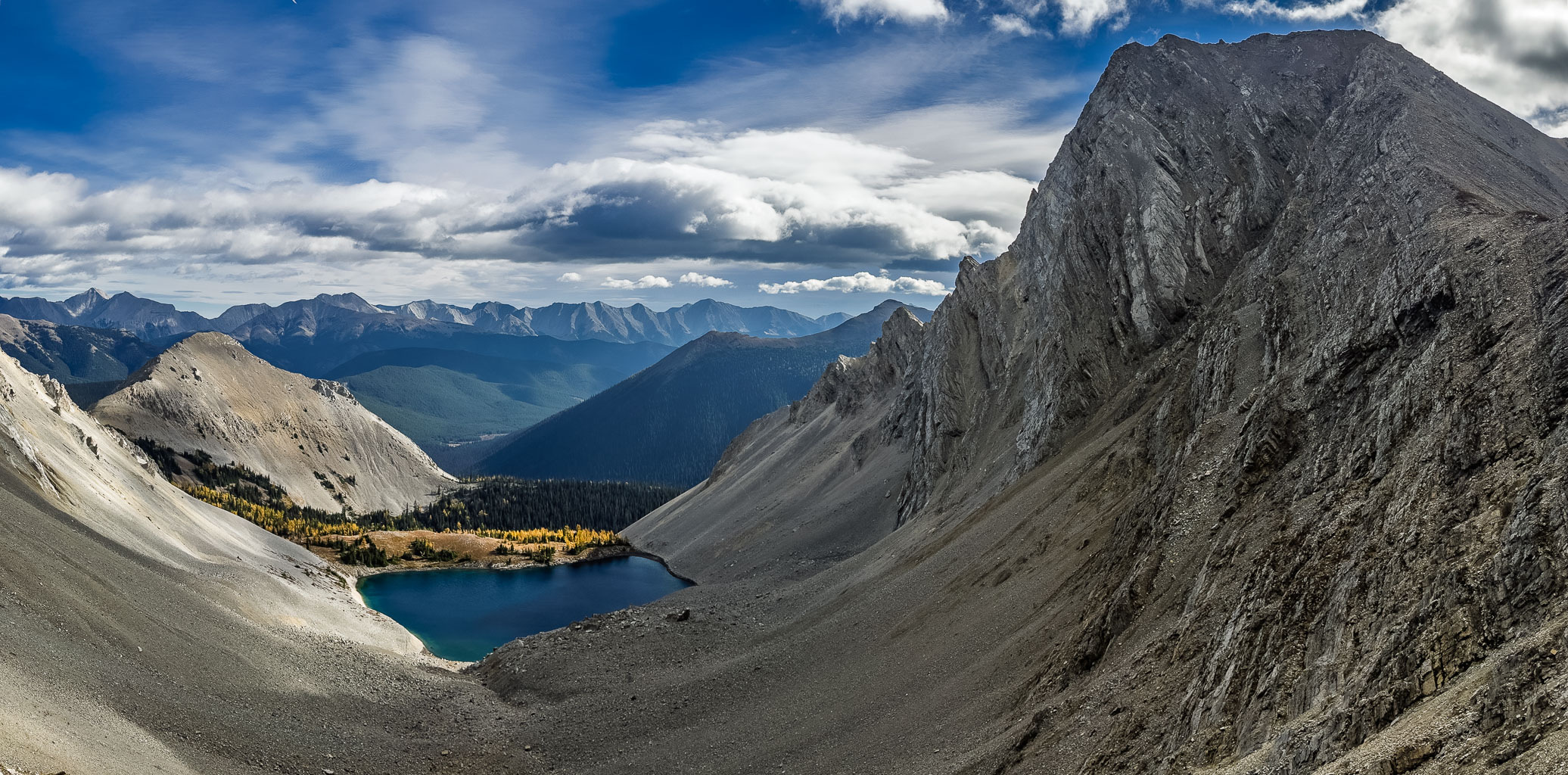
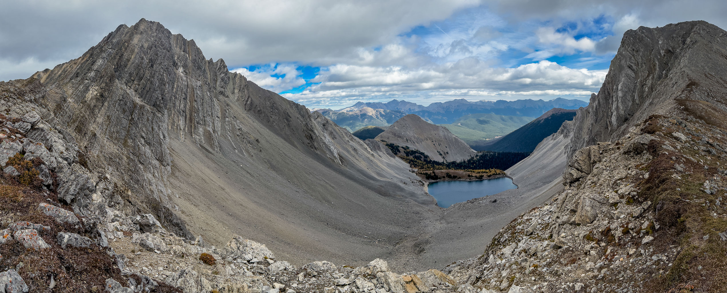
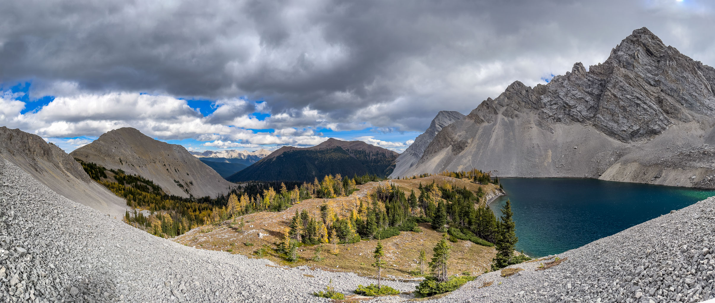
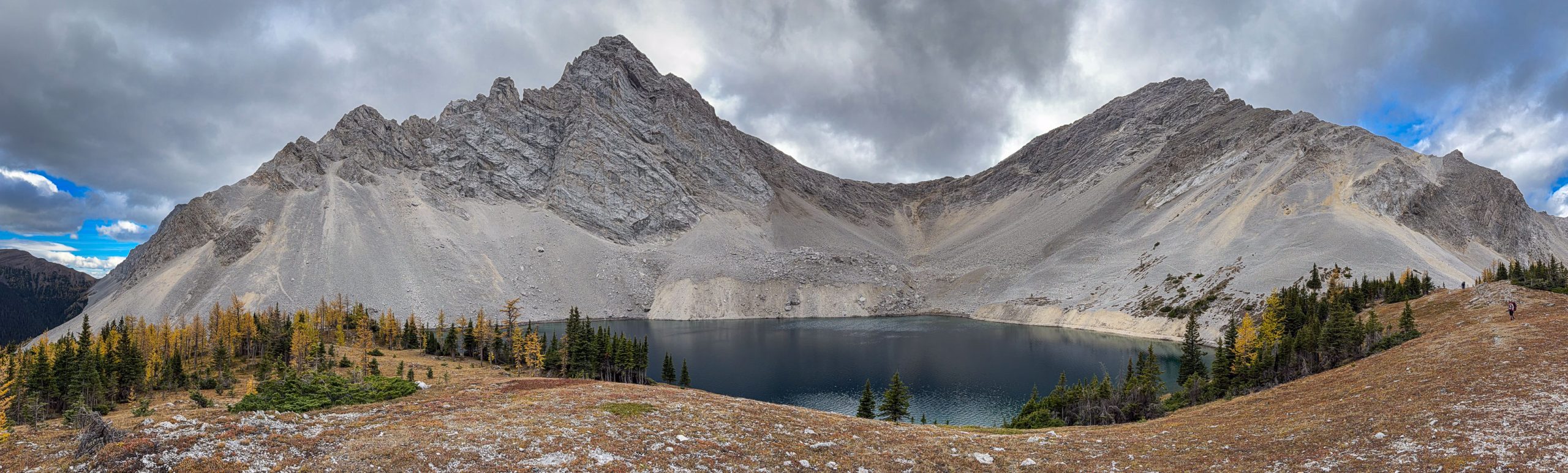
After one final grunt up steep scree and dirt (all on a good trail) I found myself at the mythical Loomis Lake with views of two of my peaks looming far above it. It took me less than 2.5 hours to reach the lake, covering 12kms on a good trail. I knew I wanted to explore the shoreline a bit (for possible future trips there) but at this point of my day I was in “peakbagging mode”.


It didn’t take me long to spot a very obvious trail running above the lake across rubble slopes towards the intimidating headwall. I quickly started towards it, following it easily above the NW end of the lake and quite high above it already. As I continued along the scree highway I couldn’t believe my luck today. The trail didn’t end, but rather continued all the way to the headwall! I even started building small cairns along it, to assist future Vern on my return trip. Views back over Loomis Lake were some of the best I’d get all day, sitting like a gem amongst the larches and overlooking the forested valleys below.

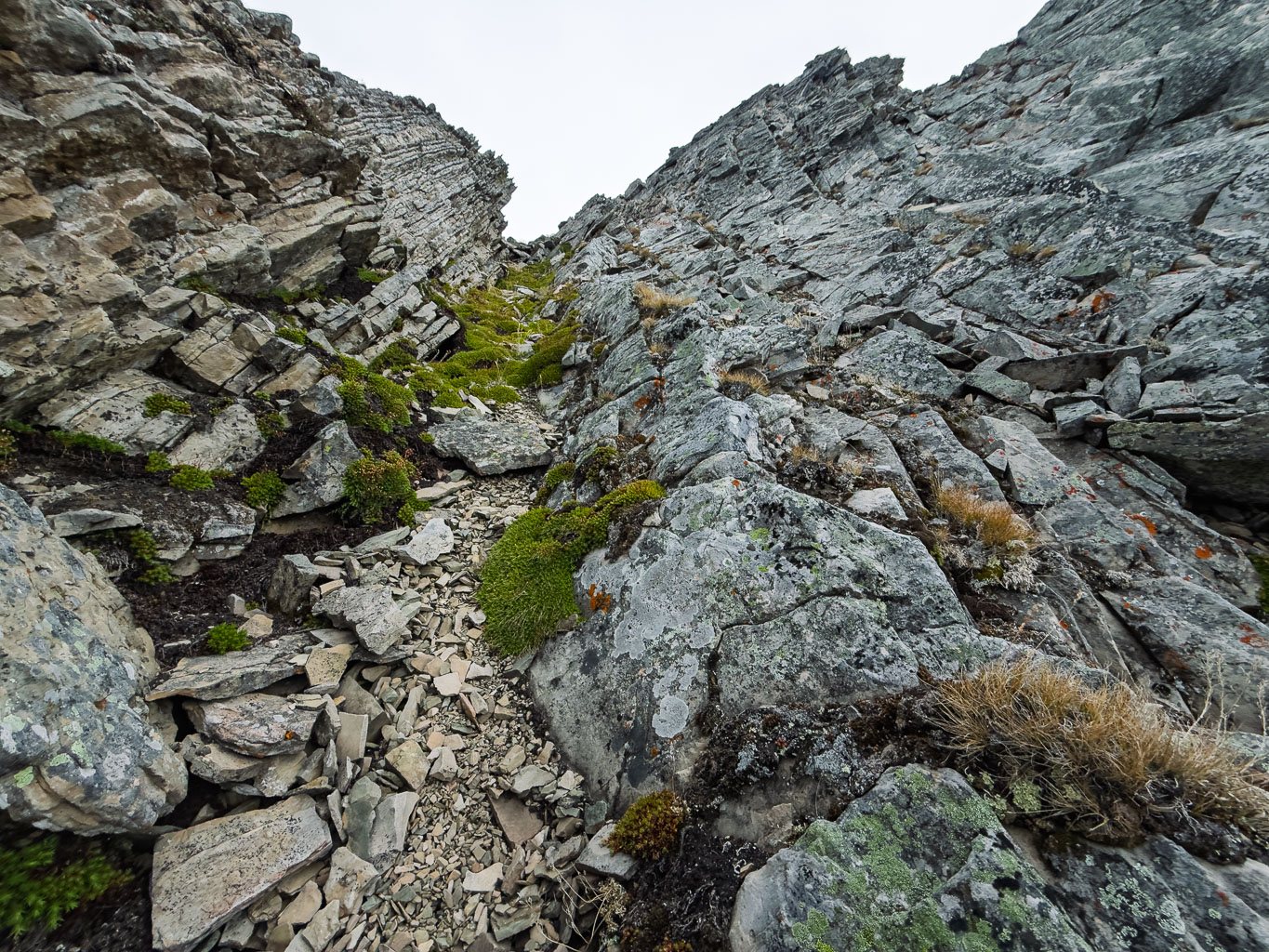
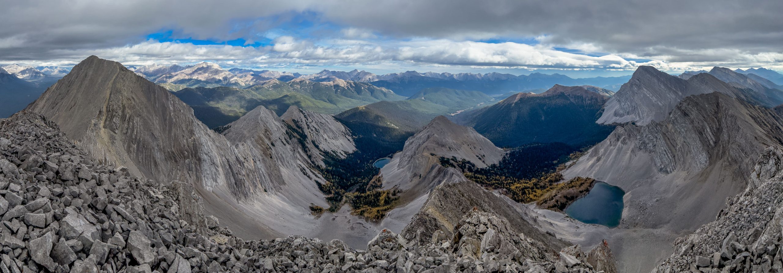
Despite looking heinous from the lake, I knew that the headwall would likely not be an issue. I’ve done Schierman routes before and he doesn’t sandbag his objectives. If he says “3rd class”, he means it. And sure enough. The headwall continued to break down and look easier and easier the closer I came. The trail actually continued right up the cliffs, splitting into several options that were all no more than easy scrambling up well placed ledges. There were options to make things harder but I didn’t bother, choosing to zig-zag my way to the south ridge of McCrae without issue.


A cold wind blasted me as clouds continued to build over the Divide. I donned my toque, gloves and extra jacket before continuing up a very spicy looking ridge on a mix of slabs and familiar Rockies rubble. I had no beta for this part of the route, simply that it was 3rd class and roughly followed the south ridge.


I did the classic “over think” thing here, choosing to deviate onto the west face a few more times than I should have on ascent. The ridge looked like it might get pretty intense above me, so I traversed gullies and slabs below it, until I had no other choice but go up. I almost got cliffed out this way but did manage to downclimb a tricky drop off before ascending some slabs and rubble to my first peak of the day. Some of my ascent route was definitely stiff moderate terrain.


Views were respectable at the summit, with clouds covering the higher peaks such as Abruzzi and King George. Many familiar Kananaskis peaks showed themselves and both “Little” and “Big” Loomis Lake were visible from the top. Unsurprisingly the wind was fierce and I didn’t linger long before starting back down to the UN2647 col.
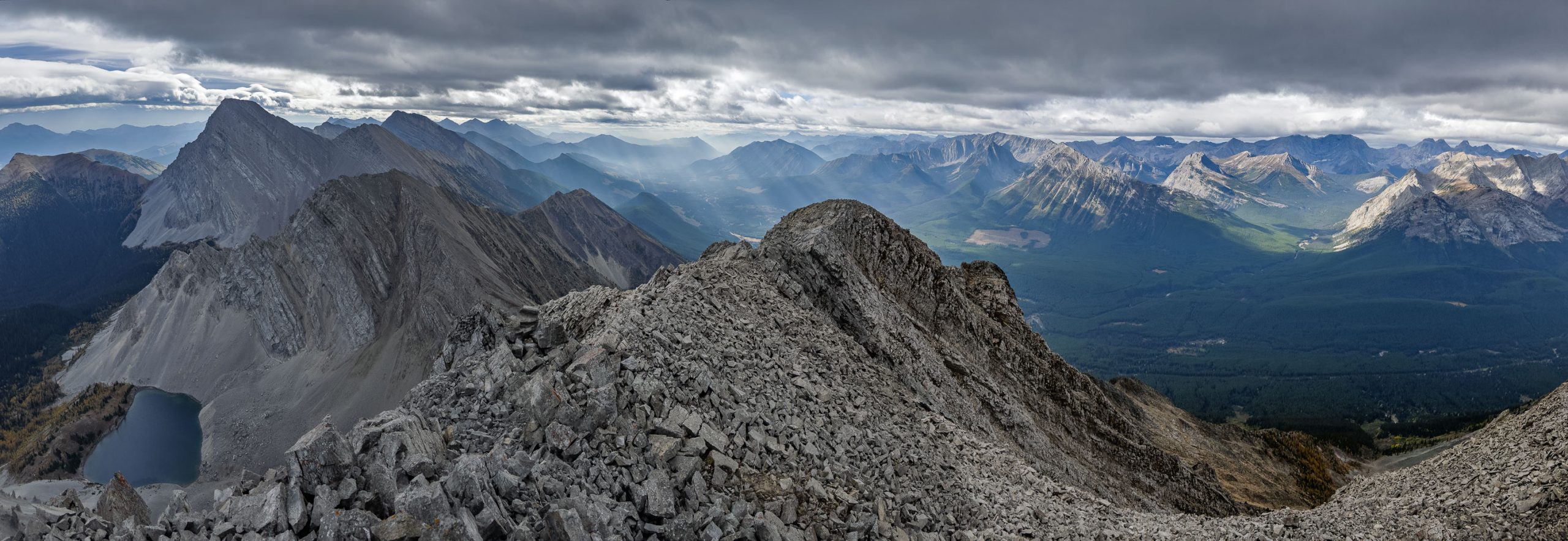
My descent route followed the south ridge much more closely than my ascent had. Several times I looked back at what I’d just descended and was surprised how stiff it looked compared to how it felt. I guess the moral of the story here is, don’t travel too far off the south ridge and trust that the terrain breaks up as you go. It’s a mix of grippy slab and dirt, making for a great moderate scramble.


4.5 hours into my day I was at the UN2647 col, ready to ascend my 2nd “peak” of the day. Clouds were now prevalent over the Divide (sunny everywhere else of course), proving Devan’s decision to wait for the next day a good one. Oh well. I was here now and was still enjoying it so I didn’t feel too many regrets. My ascent of the UN2647 was unremarkable, I basically followed the ridge, deviating on the west face where it made sense to keep things easy to moderate scrambling. It took me less than 20 minutes from the col to the summit.


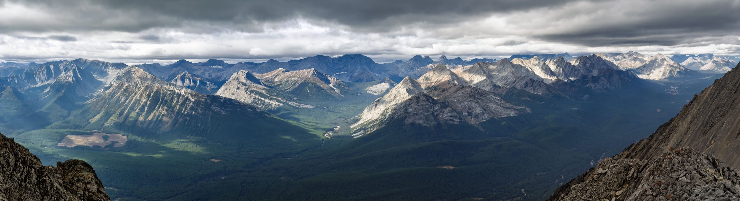
From the summit of UN2647, my third peak looked a little further than I would have preferred. I was expecting it, but still – I had to consider whether or not I really wanted it or not. It was only 12:45 at this point so I decided to continue. As usual, the traverse from UN2647 to UN2731 was slightly longer and more convoluted than it first appeared. It wasn’t exactly rocket science, but there were several drop offs to avoid, cliffs to find a way over or around and just general Rockies wilderness tomfoolery. Nothing exceeded moderate scrambling but several spots did require some scouting around to keep it there.

It took me 30 minutes to descend to the col and another 30 to ascend back up to the summit of UN2731. Despite clouds continuing to linger over the landscape, there were brief moments of glorious sunshine lighting up larch meadows nearby to the west. A particular little unnamed ridge just west of me provided the best views but a line of peaks running from Riverside Mountain to Mount Aosta were also striking in the moody lighting.


From the summit of UN2731 I had great views to Mount Bishop and its namesake lake nestled in a scree valley to the south. On my ascent of UN2731, I’d wondered about a potential descent route to the valley directly below its NW ridge leading down to the east. It looked doable but did I want to end up in that valley rather than back at Loomis Lake? The short answer was, “no”. I hadn’t explored Loomis Lake properly on my ascent, thinking I would be back there. Descending directly off the NW ridge of UN2731 would deposit me in the “wrong” valley where I’d have to bushwhack a shortcut to my approach trail, bypassing the lake. (FYI – Devan did descend here, but then he traversed back to the lake, almost negating any of the benefits of this route, but it does go.)


The return trip back over UN2647 felt a little sloggy but it was easy enough. I quickly descended back towards the col, cutting down the east face along goat trails back to my approach route over the rubble and scree highway.


I was thankful for all the cairns I’d built on approach, they were super helpful guiding me back to the lake on a good trail. It’s remarkably hard to follow trails on rubble if the sun is behind you. You know the trail is there when you’re on it but as soon as you lose it, it can be very challenging to rediscover.
Back at the lake, I was surprised to see a couple of guys hanging out there. We chatted briefly, they were camping at the alpine meadow below the headwall. This was their 3rd time at the lake and the first time they actually had decent views of it – apparently it can get very socked in here. There were multiple fire pits and a few rustic campsites along the eastern shoreline. Unfortunately the only firewood in the area seems to come from live trees and a number of them were cut down. This is obviously NOT something that should be taking place in such a sensitive natural area. Any tree takes a LONG time to grow here and cutting them down for your own enjoyment is more than a little selfish IMHO.


As I checked out the thin larch forest just off the lake atop the headwall, I ran into two more folks. These were fly fishers, obviously planning to set up a camp near the lake and try their luck for the stocked Cutthroat that were occasionally breaking the surface of the waters nearby. It was time for me to start my exit and wished them “good luck” (hoping they weren’t tree choppers) and started down the headwall.
My return was a mix of larchy goodness, the magical traverse valley and little stream and a steep descent to the bike. I was concerned that the ride back might be slow and tedious but as usual, it was the very opposite of that! I managed to return to my new Rav4 along hwy 40 in less than an hour, including all 6 water crossings and the PITA muddy hill climb.


I really can’t say enough good things about the Mount McCrae / Loomis Lake outing. I highly recommend this for any Rockies adventure seeker who likes reasonable (but still rough) bike approaches, wonderful hiking trails through larch forest and sublime backcountry lake scenery. The hiking and scrambling along this route is excellent – on trails from the parking area all the way to the headwall. Bring your fishing rod and tent for added fun. This is a little slice of heaven along the Great Divide that any (responsible) backcountry user should experience at least once. I know that I will be back some day to enjoy the peace a little longer.


Hi Vern, the link provided for Gaia’s map points to your 2021 Odlum and Loomis trip and not for Mt McCrae….(I was trying to download your track for a future trip)
Cheers
Thank you sir, I’ll fix that right now.
Hi Vern,
I was wondering whose Rav4 is in the ditch when driving to Cat Creek day use to hike Mount Strachan that day. Windy and quiet fall day hiking in Highwood. I have been following your hiking report for years and have a feeling that I might be running into you someday, especially on one of those long treks. I have bumped into Kane and Nugara before.
Haha! That’s awesome. I’m sure we’ll run into each other at some point!