
Summit Elevations (m): 2996, 2958
Trip Date: September 02 2023
Elevation Gain (m): 1550
Trip Time (hrs): 9
Total Trip Distance (km): 25
Quick ‘n Dirty Rating: Class 3/4 – you fall, you break something or die
Difficulty Notes: Very hard to rate this one. A slip along many sections on both peaks is very ill-advised but Zeke’s is significantly more exposed for much longer. F 3rd with extreme exposure is the best rating.
Technical Rating: SC7
GPS Track: Gaia
Map: Google Maps
First Ascent: Both by guide Bernie Schiesser. Whistling Rock in 1972, Zeke’s in 1973. See below for more details.
I don’t remember when I first heard of Zeke’s Peak. I do remember that it was an odd enough name that I instantly wanted to do it. When I saw in David P Jones’ climbers guide that it was only rated F 3rd it went near the top of my list. Since then, I’ve slowly come to realize what “F 3rd” actually means. It’s the climber’s version of the scrambler’s rating of “moderate” or “SC6”. Which is to say that some folks will find many F 3rd scrambles more like a hike and others will swear it’s the hardest thing they’ve ever done. Whistling Rock Peak is the only peak listed on Mount Sir Douglas’ long NW ridge on bivouac.com with a subsequent trip report from Rick Collier – in winter conditions of course! Both of these peaks perfectly bring to reality the challenge of the F 3rd rating. I am pretty sure that in either Kane’s or Nugara’s scrambling books Zeke’s would be rated “difficult” and Whistling Rock would be rated “moderate”, hence me rating it at “SC7“.
The history of both Whistling Rock Peak and Zeke’s Peak is courtesy of mountain guide Bernie Schiesser. In the 1973 CAJ Vol 56, pg 109 the FRA of Whistling Rock Peak by P. Poole, P. Findley, M. Gould, J. Noakes, C. Findley, M. Rosenblum, S. Sabey with Bernie Schiesser (guide) on July 28 1972 is recorded,
The northernmost of the two peaks on ridge running north from Sir Douglas. The ridge was attained on the north end by easy climbing. This provided some spectacular views where it knife edges, but most of the ridge is wide. Traversed until the final buttress. Here we traversed on the east side of the ridge for 200 feet to the top of large pillar. From here we ascend directly up the first gully for 180 feet and then worked left (south) and onto some easy climbing to the summit ridge.
Of course the “two peaks” on the ridge are Whistling Rock and Zeke’s. In the 1974 CAJ Vol 57, pg 116 the FRA of Zeke’s Peak by L. Jennings, J. Connell, C. Evenchick, J. Wheeler, S. Dayton, guide B. Schiesser on July 18 1973 is recorded,
Northern ridge of Sir Douglas. Summit 1 mile north of Sir Douglas. Approach from Burstall Lakes and pass to Palliser Valley (NW of objective). North end of ridge attained from west side, ridge then traversed to its south end and summit. Rock on ridge very good; the ridge very sharp for its full length. Descent by same route with 1500 ft glissade.
Despite David Jones’ description telling us that a dog (named “Zeke”) joined in the 1973 expedition, I could find no such confirmation from the first ascent account that a dog made the exposed traverse for a few hundred meters to the summit. As you can probably tell from my tone, I highly doubt that this happened and it shouldn’t make you dismiss this peak as “easy, since Bernie’s dog did it”. That would be a mistake! An even bigger mistake would be bringing your own dog along for this scramble – it is most certainly NOT a place most (any?) dogs would be safe or comfortable along.

Doug Lutz recently scrambled the entire north ridge of Whistling Rock Peak and reported back a straightforward descent down west slabs to valley bottom. I knew I had to give that route a try since there was no way I was going to follow him all the way along that north ridge. Since Zeke’s Peak is right there it made sense to combine them. Devan Peterson put up a track for Zeke’s on Strava and confirmed it was F 3rd but quite exposed. I was intrigued and excited to try them sooner than later. While standing on Andy Good Peak the day before, I texted Sara to let her know that things were going well and I was feeling like a trip the following day. We had chatted earlier in the week and I warned her that I might need a break between days out but the weather was forcing our hands a bit on this one so why not bag 4 peaks in 2 days? We agreed to meet at the Burstall Pass parking lot at the late hour of 08:30 and I continued with my day towards Chinook Peak.
The drive went quicker than expected so by 08:20 we were peddling out of the parking lot past some confused hikers up the well traveled Burstall Pass Trail. (I think many folks don’t realize the first 3+ kilometers of the trail can be biked, saving a lot of time and making the exit more fun.) Soon enough we were locking the bikes and continuing on foot. We tramped across the wet Burstall flats, managing to keep our feet dry somehow. We didn’t clue in at the time but both of our peaks featured prominently on the amazing view up the shrinking Robertson Glacier towards Mount Sir Douglas.


We quickly gained height up to the alpine meadows under Snow Peak and Burstall Pass before continuing on a good trail almost up to the pass itself. From here Sara remembered a faint trail running to South Burstall Pass. I should have remembered it too, but it’s been many years since I last wandered this area in summer conditions.

Back in July of 2015, Steven, Ben and I hiked up these meadows in late afternoon before bivying under the NW glacier on Mount Sir Douglas. I forgot my sleeping mat and ended up sleeping on bare rocks for the night. The next day we ascended the 11000er in pretty marginal conditions. Ben was sick and Steven dislocated his shoulder on descent! Quite the adventure by some mountaineering noobs who likely got away with one on that particular day… Good memories as Sara and I strode across the always-striking landscape of the Burstall Pass area and took in the views of our two objectives. Despite being the easier peak, Whistling Rock looked a bit fierce from this angle.


As we approached the easy west abutment ridge to Zeke’s Peak we got wonderful views over South Burstall Pass to the Palliser Pass area and peaks such as Queen Elizabeth, King Albert and Craddock. I remembered the most efficient ascent of this ridge and we followed it easily up to the crest before continuing towards the west face of our objective.


As expected, the west face slopes were an easy ascent from the abutment ridge and soon we were staring at the NW ridge running in a knife edge towards what we assumed was the nearby summit. We were expecting this and so it didn’t shock quite as much as it might have with the “F 3rd” in our minds. There was a very stiff, cool west wind howling over us as we bucked up and started along the ridge, at first walking upright and then scampering along aside it with one or both hands grasping the rough edge at the top of the ridge and our feet at crazy angles gripping the rock that dropped precipitously a few hundred vertical meters to our right.


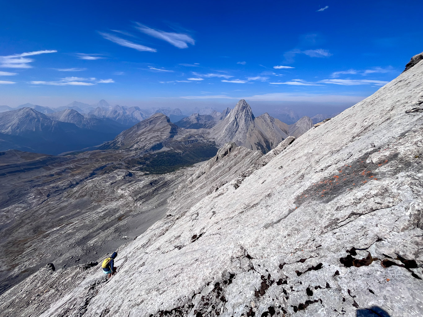
As we went on and on and on, Sara yelled back, “where’s the dang summit?!” and I agreed with her sentiment. It was much further than either of us expected when we first topped out and looked south along the ridge. There were at least 3 or 4 false high points – the summit is naturally about as far as you can go without actually getting onto Mount Sir Douglas proper! I have to say though – the scrambling was delightful. Without the hurricane and cold I’m sure I would be classifying this as a top 20 scramble, it was that much fun.


We managed to duck out of the cold wind at the summit and enjoyed a nice break before donning jackets and gloves for the return trip. This was much better! The gloves protected from both the stiff, cold winds and the very rough rock. There’s climbing routes up the west face that must be pretty fun but also very much like ascending a cheese grater.


At the top of the west face descent route to the abutment ridge we turned downhill, easily descending slabs and rubble to the top of our planned traverse line towards the lower west face of Whistling Rock Peak. We had to be careful on the rubble as there were slabs buried near enough to the surface that sometimes we’d take off a bit quicker than planned.


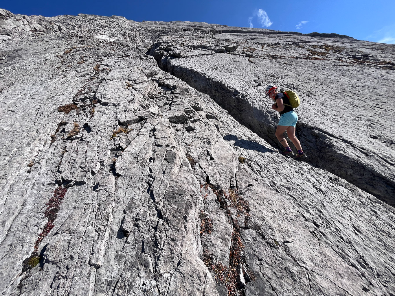
The traverse to Whistling Rock was quicker and easier than we expected. We didn’t bother staying too high – it wasn’t worth stumbling and bumbling about on loose rubble slopes, as much as I do enjoy side sloping on approach shoes. At the bottom of the west face we found ourselves looking up at some fun looking slab terrain.

The next 45 to 50 minutes were spent ascending a very fun mix of slab, scree and cracks along the west face to the upper ridge of Whistling Rock. This was quickly becoming the slab scramble delight of the summer! I’ve been on quite a bit of slab recently including Cuthead, Goodair and the day before on Andy Good. This was harder than all of those but also easier. The slab was clean, grippy and FAST to ascend.


After a very quick ascent we completed a short (and very easy compared to Zeke’s) traverse to the summit. This time it was as close to the ascent route as we expected it to be. After signing Doug’s register we took another break, taking in the wonderful views and many familiar mountains and valleys.


Descent was a bit tricky on the upper west face with steeper slab and some runout. You certainly don’t want verglass or fresh moisture up here! We took our time but still ended up descending quite fast. The rock was good where it needed to be and loose where it helped speed us along.


Finally we found ourselves hiking back through the lovely, calm Burstall meadows back to the trail and down to our waiting bikes. The walk through Burstall Meadows was a bit of a disaster with water flowing everywhere and no possible way to easily keep our feet dry, unlike earlier in the day. It felt good to soak the feet after having them all torqued around on slab all day anyway.


We ended the day with a fast and furious bike ride back to the parking lot. It’s funny because I say it all the time, but biking anything over 2km of approach is almost always worth it at the end of the day. I was surprised that we took as long as we did on this relatively straightforward bushwhack free day, but there was enough tricky terrain to slow us down a bit I guess. I strongly recommend this trip for confident scramblers with a good head for heights and exposure and sure footing. Try to pick a warm, windless day and enjoy the fun routes and great views. This trip may well end up on my top 10’s page somewhere this winter as I digest it a bit more.