Summit Elevation (m): 2250
Trip Date: Friday, April 02, 2021
Elevation Gain (m): 970
Round Trip Time (hrs): 5.5
Total Trip Distance (km): 16.5
Quick ‘n Dirty Rating: Class 2 – you fall, you sprain your thumb
Difficulty Notes: No difficulties other than routefinding your way up various OHV tracks and several sections of light bushwhacking.
Technical Rating: OT3; YDS (Hiking)
GPS Track: Gaia
Map: Google Maps
This is the time of year when you have a few choices when it comes to being a peakbagger / hiker / skier / whatever you identify as wrt outdoor activities. The first and most enticing option is often to stay home and enjoy sunshine and warm temperatures in YYC. Go for a nice long morning run and enjoy a cup of coffee on the sunny deck afterward. Then, if you’re like me, you start wishing you did a little more… You can go skiing in variable conditions from rock hard snow to dust-on-crust to a terrible mixture of both. On a sunny day this is worth it for the right objective. Most of my icefields trips have been in variable Spring skiing conditions and almost all of them were more than worth it. You can hike up dry front range hills and ridges, desperately hoping that you don’t come home covered in wood ticks while playing “whack-a-peak”. The fourth option is in many ways the least attractive but I always end up doing a few of these every spring, despite knowing better. This option consists of snowshoeing up mid range hills or ridges and hoping for the best. It’s the ultimate hiker’s gamble – will the destination be worth the journey or will I come home wishing I didn’t bother?

When Wietse and I hiked Loop Peak back in the early Covid days of April 2020, we looked back across Corbin Road towards Sparwood Ridge and wondered if it was worth a trip up there. We knew from Alison Sekera’s trip report that there was a route from the east starting at Corbin Road and following a confusing mix of OHV tracks and cutblocks to the NE ridge and summit. We also knew just from looking at the terrain that this wouldn’t be a “top anything” objective. The views from the summit looked good enough that a year later, with a Friday off and not much else going on, I decided to give it a shot as a solo hike / snowshoe. Very foolishly I was assuming that a good chunk of the approach would be melted back but packed the ‘shoes just in case. Yeah right! After crossing Michel Creek from Corbin Road I almost immediately donned the ‘shoes. The track was icy and what little snow there was seemed to be collapsing already in the early morning heat. I followed Ali and Matt’s GPS track and directions closely – there are enough tracks around here to quickly get lost – hence I am making my own track available too. After hiking up Michel Creek I turned right along a less used snowmobile track before going left on an unused track leading to the overgrown old road section.

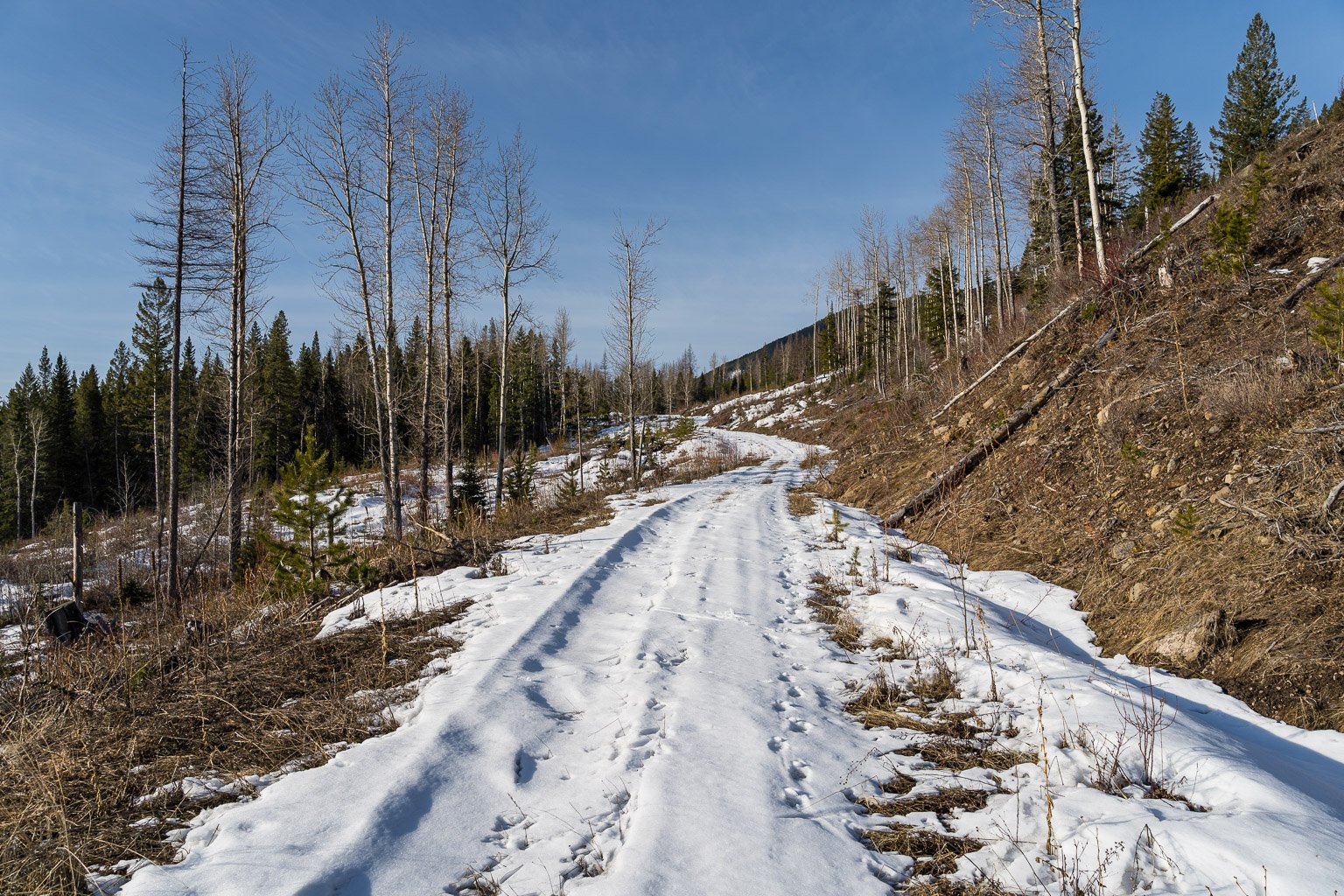
The day was beautiful enough to keep going but as I crossed a small creek (delicately balancing on a log) towards the obviously overgrown logging road I wondered seriously for the first time if I was timing this objective right. The temperature was too warm – the snowpack was quickly collapsing under my snowshoes even in the shade and I had a LONG way to go from here yet! Having driven over 2 hours and having the whole day in front of me I decided to thrash up the road at least. And thrashing it was! This was the worst section of the day – but not the last of the bushwhacking unfortunately. Ali says this section is about 1km and she’s correct. At least on ascent the snow was mostly frozen over – I worried quite a bit about my return through here. Eventually the overgrown trail merged with a newer one that led quickly to the first big cutblock that the route travels through.

Again, using Ali’s directions and Matt’s GPS track I managed to get through the first cutblock section without issue. The first half was easy on a packed snowmobile track. The second half sucked on a collapsing and sticky snow pack to the SW end of the block and the 2nd bushwhack of the day. At this point I was lifting at least 5 extra pounds of snow on each foot with each step. This was not going to be the easy or pleasant trip that I had in mind earlier!

The short section of forest after the first cutblock was thankfully very short but I did not appreciate the steep unconsolidated trail breaking it entailed! I broke out of the trees and traversed to another recent snowmobile track leading towards another cutblock and obvious snowy hill that I would have to ascend. This traverse and hill were the highlight of my approach. The snow was solid and not sticky and the hill provided a simple challenge – after 79 Prairie Mountains this year so far, I didn’t mind going uphill. Ali slightly undersells the following few sections to the NE ridge of Sparwood;
Keep going WNW / NW along the easiest path until you can pick up the final FSR to the summit. Take that until you see the ridge. Get up onto the ridge and follow it up to the summit!
She’s technically 100% on point but it’s the effort that’s undersold here. From the top of the open hill it’s 3 sections of bushwhacking with short sections on OHV roads in between. I wasn’t prepared mentally for the amount of bush – it was pretty light but the snowpack was terrible. Every step was an extra 5-10 lbs of sticky snow and up to knee deep. Put it this way – I got more of a workout than I bargained for.
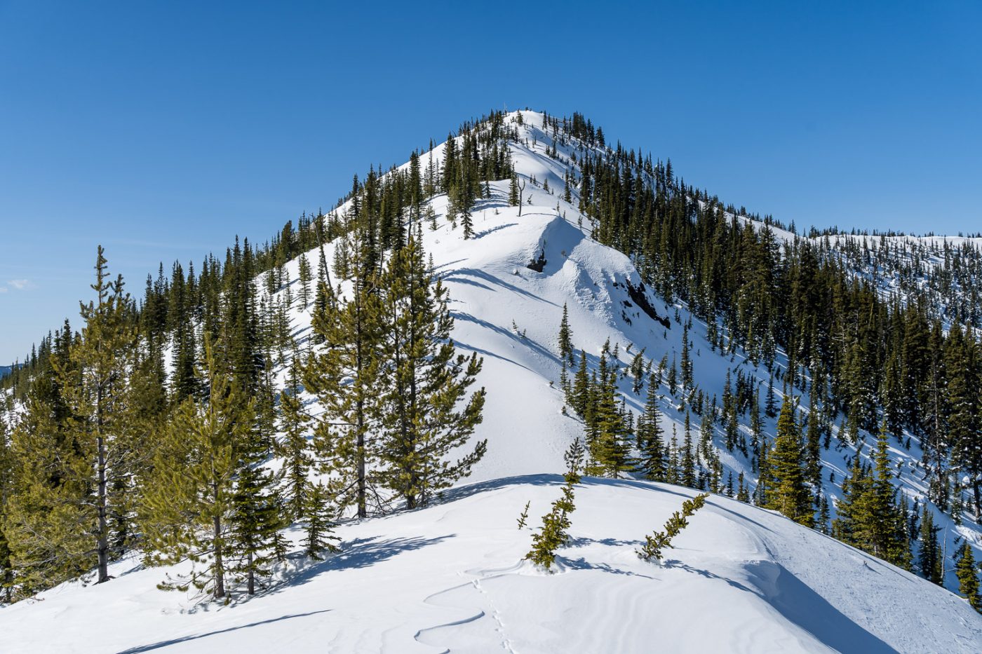
Finally I found myself on the upper road running just SE of the ridge proper. I cranked a right hand turn and found myself on the ridge with the summit rising ahead in front of me. The snow to the summit was boot top to knee deep and insisted on riding along the bottom of my ‘shoes making for tough travel. There were a few steep sections along the ridge that could slide or be exposed to slides in the right conditions but everything was pretty locked up for me and I didn’t feel unsafe to the summit.

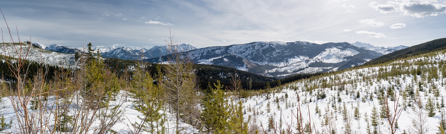
The views from Sparwood Ridge are pretty darn good. I took in the sights of many unfamiliar and a few familiar summits around the Crowsnest Pass and Fernie areas. The wind was cool and at this point I was still considering a 2nd peak for the day so I didn’t linger long and started following my tracks back down the ridge.


The trip back was MUCH easier than the ascent had been! It took me 3.5 hours of steady travel to make the summit and only 2 hours of fairly leisure travel to reverse it all. So, would I recommend Sparwood Ridge? Probably not to the average hiker / snowshoe enthusiast to be perfectly honest. I had a nice day traveling in a “new” area with some unique views but there is enough route finding, bushwhacking and stumbling around on this ridge to justify perhaps waiting for the easier west access roads to dry off before tackling it. For the determined peakbagger with a day off and a penchant for suffering this is the perfect destination.