Summit Elevation (m): 2446
Elevation Gain (m): 1400
Trip Date: January 30 2021
Round Trip Time (hr): 12
Total Trip Distance (km): 40
Quick ‘n Dirty Rating: Class 2 – you fall, you sprain something
Difficulty Notes: The difficulty with skiing Elaphus Peak lies in its location rather than any technical difficulties. It’s a long approach on fat skis and the north aspect tends to hold pretty bottomless snow. There is also avalanche terrain on this route.
Technical Rating: OT4 (Skiing)
GPS Track: Gaia
Map: Google Maps
The mighty Elaphus Peak has finally fallen in winter! Ok, ok – I’m not claiming a first winter ascent but I challenge you to find mention of another besides ours. You may not even know where the heck this officially named Banff National Park summit is, nevermind who’s done it first in each season. I first heard of “Elaphus” from Phil Richards who biked ‘n hiked it in 5.5 hours in late May 2019. Yes that’s right. 5.5 hours for 40km of travel including a summit! Now go back up and look how long it took Wietse and I on backcountry skis. Now stop laughing… Ever since Phil ascended the peak via NW slopes and told me how easy it was, I’ve been planning a ski ascent. I’ve walked past this peak a few times recently, including a 52km day trip of Haunted Peak and a recent 2-day journey into Panther Mountain and Flints Peak. I’ve even xcountry skied the Cascade Fire Road to the Stoney Creek crossing and really enjoyed it – so I knew before we even started this silly adventure how truly silly it was going to be. Put it this way – Mount Collie is one of the longest day trips you can do on the Wapta Icefield and sits at 33km return with 1900m of elevation gain. I did that trip in 11 hours in 2014. As we drove to the trailhead at Lake Minnewanka early on Saturday morning, Wietse and I both commented on how we weren’t feeling that “psyched” for this trip. That is NOT how you want to start most 40km days in the hills. We were excited to be on something other than Prairie Mountain (I did 35 laps of that peak in January alone) but neither of us had high hopes for a successful summit or very good conditions on the peak.

Wietse and I have both been trying to get in shape and change our shapes since November 2020 with some encouraging success. Part of this effort has involved many laps of nearby Prairie Mountain – often together and often multiple laps in one trip. I managed 3 triples and 35 total ascents in January 2021. My commute has changed from a morning commute downtown to work, to an evening commute west to the mountains. I must admit that I’m getting a little bored with Prairie but I have noticed the results, both in my waistline and my fitness levels. After seeing some trip reports on skierbob.ca that indicated a fast track up the Cascade River Fire Road I started bugging Wietse that maybe we should attempt Elaphus Peak on skis sooner than later. I was initially planning a Spring ascent but there were problems with waiting too late in the ski season. We wanted a fast approach track – not melted out. We wanted snow on the ascent slopes. We needed the Cascade River to be either completely frozen over (preferred) or at least very low for our crossing to the Elk Pass Trail. We also wanted to test our our fitness since it had been a while since we’d done a longer trip on skis. Of course there were also some downsides with doing this trip in January. Less daylight meant headlamps for a good part of the day. A shallower snowpack was almost guaranteed and colder temps ensured we’d likely have a bottomless snowpack on the north slopes. With avalanche conditions and weather lining up nicely for the weekend of January 30th we decided to give it a shot. I picked Wietse up from his house at 05:30 and we left a cool-but-not-horribly-cold parking lot at around 07:30 with our headlamps on. The trail was nicely packed beside the set tracks and we made good progress to the 6km bridge over the Cascade River where the temperature decided to drop off a cliff in the valley bottom to at least -17. I wasn’t very happy at this point and was once again questioning my life choices – especially the f’ing weekend ones. Three hours from the parking lot we finally arrived at the Stoney Creek warden cabin and got our first good look at Elaphus Peak rising over the old Carleton cabin.


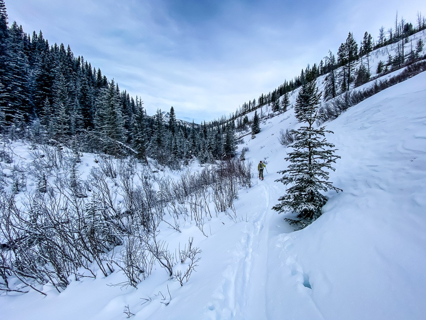
From the warden cabin we were expecting to be breaking trail so the appearance of a snowmobile packed trail leading off to the Cascade River was a great mood booster. We followed along the packed trail for around 1km before noticing a single ski track heading into the bush to our left and presumably the Cascade River. The line on Gaia that looks like a trail isn’t. (On return we found a better trail that was also skied from the Stoney Creek horse camp and this is the route I’ve included on the map above.) We followed the track through the bush – it wasn’t horrid but certainly wasn’t a cleared trail either. Eventually we passed a large horse camp at the confluence of the Cascade River and Stoney Creek and followed tracks to the hikers crossing of a still-flowing Cascade River. When planning the trip I’d almost forgotten about the issue of the river crossing. Thank goodness I re-read Phil’s trip report and it jogged my memory on this extra little bit of “fun” for a winter trip. Thankfully I have some good river crossing pants from my canoe trips that are waterproof Gore-Tex with built in booties that are very lightweight. Wietse and I both carried water crossing shoes as well – I used sandals which worked much better in winter as Wietse’s shoes were so frozen from the first crossing that he couldn’t use them later in the day on return! We had to be careful when crossing the river to ensure we didn’t break through thin ice on either side and cut our pants or fall in, other than that the crossing was fairly straightforward.

Once across the Cascade River we realized that there were ski tracks continuing up the Elk Pass Trail, coming in from our right where the horse crossing is located. We got excited for our return trip thinking that perhaps these skiers found a snow bridge to cross. That was a possibility for “future Wietse and Vern” to explore. We left our crossing gear behind and continued up the Elk Pass Trail following a skinny ski track. We could see from the pole marks that whoever had left the tracks had been descending from Elk Pass and I was impressed that someone on skinny xcountry gear had navigated the narrow canyon in the marginal conditions it was in. They must have had a bit of “fun” here on that light gear. We weren’t very far up this trail before I noticed that the creek running down the drainage towards the Cascade River was pretty energetic and flowing much higher than I expected. I yelled ahead to Wietse that we might want to turn back and pick up our water crossing gear for a possible 2nd wade of the day. He agreed and we quickly returned for the now frozen gear before turning back up the trail again. The trail to Elk Pass was much more interesting than I was expecting. It was in sporty, low snow condition with some rocks and roots showing through, but generally was in decent shape. Evidence of the 2013 flood event was visible especially in some of the narrower spots and we crossed at least 2 or 3 avalanche slopes as well. As we neared our NW ascent route on Elaphus we were surprised to see the track crossing a nice little bridge over the creek! That was an unexpected surprise. Strange that a small creek is bridged while the Cascade River isn’t. I guess this bridge survived the floods. We dumped our water gear near the bridge and continued up the track for a few hundred meters before looking left for a viable route up Elaphus.

So far our day was going pretty well. We were expecting a 10 hour day (well I was, Wietse was much more optimistic) and were on track for it. It had taken us approximately 4.5 hours to the base of the NW ridge of Elaphus and “all” that was left to do was a ~650m ascent to the summit. One measly Prairie Mountain, which we do at a relaxed pace of 55 minutes nowadays! But of course you know that everything went to crap right at this point don’t you? North slopes are funny when it comes to snow and ski ascents. You’d think they’d be safer and more stable than south slopes due to less melt/freeze cycles and you’d be right. But they are also much more likely than south facing slopes to be loaded with a bottomless, sugary snowpack due to temperature gradients and the lack of any warmth to promote a nice hard slab or two. To make a very long and tiring story much shorter than it was, we spent the next 2 hours struggling up a horrible snow pack before finally gaining 400 vertical meters onto the NW ridge proper. The longer version isn’t much more interesting. After starting out optimistically at the bottom of the slope we soon realized we were in for a bit of an epic ascending the forested NW end of Elaphus.


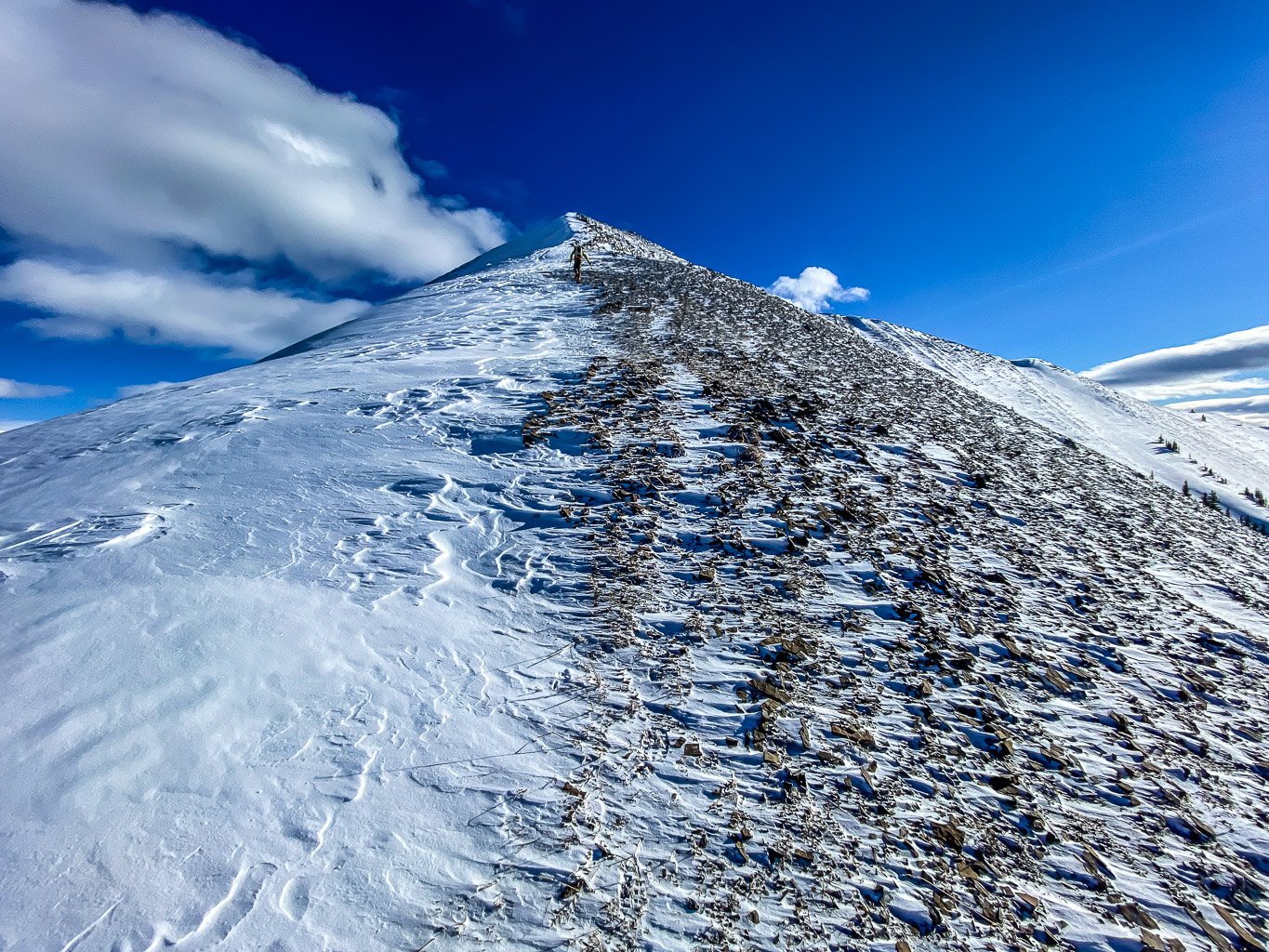
We took turns breaking trail but it was rough! Deep, bottomless sugar was made even worse with tree wells, rocks and buried shrubs and small Christmas trees. As we worked our way higher I could see that the rocky ridge was going to be an issue and we started traversing slopes just under the ridge to the west. These slopes were still bottomless and were now definitely steep enough to slide, which thankfully they showed no interest in doing. We’re pretty stubborn and we both knew we were going to make it but slowly we also realized our day was going to be significantly longer than either of us had originally thought. By the time we finally gained the ridge proper it was 14:00. The snow on the ridge was razor thin but we stubbornly kept the snow sticks on and continued to the peak. It felt good to be moving at a pace of some sort again and the views in every direction were stunning under a brilliant blue winter sky. Sira Peak stole the show but I kept glancing over at Haunted Peak – remembering a 52km day trip from the spring of 2020.
We gave up on the skiing when the snow finally gave up on the ridge. We were expecting to boot pack the final few hundred meters as we knew the small summit would be wind hammered and likely bare rock – as it was. No matter. We stepped off the boards and resumed a plod up towards the distant summit in a stiff – but thankfully warm – westerly wind. I was surprised to be warm in just my fleece hoodie with a t-shirt underneath. Finally 7 hours after leaving the parking lot we stood on the not-so-lofty summit of Elaphus Peak!

I’m quite certain we were a SKA – Slowest Known Ascent for this diminutive Banff summit, but for a small peak it sure packs some mighty large views! Sira Peak still stole the show to the west but the north end of Cascade Mountain was impressive to the south. Distant views of Flints, Cuthead, Panther, “Stoney”, Haunted, Psychic, Revenant, Spectral, Aylmer, Astley, Girouard and Inglismaldie were also unexpected. Many other unnamed summits and ridges dominated our view, especially the ridge that separates the Cascade River from Stoney Creek (spelled “Stony” on my topo but that’s wrong).


After enjoying the views in a stiff westerly wind we realized we’d better start the long descent back to the warden cabin and then out to Lake Minnewanka. We slowly descended the NW ridge in our ski mountaineering boots before locking back in our skis and slowly skinning down the skiff of snow on the upper ridge. We kept the skins on to protect our bases! Once on steeper / deeper NW slopes we took off the skins and very carefully skied down to the Elk Pass Trail. We had to be very careful on this descent since there were many buried hazards on this slope and the snowpack wasn’t stiff enough to completely cover them all. Keeping the tips up and moving slowly was the key to survival here – which we mostly managed to do. I can say this with full confidence – descending that slope was much, much quicker than the ascent of it was! We donned the skins again for the descent to the Cascade River simply due to a thin snow pack and barely buried hazards. There was no room for turns anyway and we still went much quicker downhill than up with the skins on. Despite hoping for a snow bridge we ended up in the waders again – this time at the horse crossing of the Cascade River. The water was shallow and the crossing was easy enough but Wietse couldn’t wear his shoes because they were frozen so stiff from the morning crossing! A lesson learned – bring sandals for river crossing in winter as they are more bendable when frozen.


From the river crossing we retraced our tracks to the Stoney Creek horse camp. From the camp we discovered an actual trail (with ski tracks) back to the snowmobile packed trail leading to the Stoney Creek warden cabin. At this point we knew we were flirting with a 12-13 hour day and settled into things again, skinning up the long hill from the cabin at around 17:00. We kept the skins on until the top of this first long climb and then gambled with taking them off. The gamble with backcountry skis and taking the skins off is that while every downhill is much quicker and easier, every uphill – no matter how big – is now a heckuva workout. Without skins on you have to have good xcountry technique and a lot of shoulder and arm strength to efficiently ski uphill with no wax and no grip. With 10 hours already under our belts the energy required to ski uphill with zero grip was lacking to say the least, but we made do. It was worth it for the long, gentle downhill sections until the 6km bridge where the skins went back on for the upcoming ascent.


I have to admit that skiing along the Cascade Fire Road at night with a million stars overhead and only the slender beam of our headlamps to light our path was pretty special. There’s nothing quite like the end of an epic day in the hills – the feelings of satisfaction and the glow of many hours of exercise add up to an energy that’s hard to explain. I’ve lost count of the number of times I’ve exited a long day in the dark, but all of them are memorable and wonderful experiences. Don’t get me wrong! I’m happy to be done them but also happy to have the experience. Blasting down the final 1.5kms to the Lake Minnewanka road in pitch darkness with Orion’s Belt twinkling overhead was incredible. I loved it and didn’t want that moment to end. We stopped near the road and turned off our headlamps for a few moments to take in the night sky above. Then it was skins-on to the parking lot where we couldn’t believe we were finally done! Phew. What a day! Elaphus may never be high on anyone’s list – especially for a ski objective – but it feels great to have survived the experience and proved it can be done “reasonably” as a day trip.
Nice! I had my eye on Elaphus this summer but never quite found the time to do it. Good to know my (lack of) ski skills aren’t the only reason I shouldn’t attempt it in winter… I think I’ll save this one for a crisp fall day.
Haha. You’re not the first one to make that comment! 🙂
When I read your post on SkierBob, I said aloud, “What on earth is Vern doing way up the Cascade fireroad on AT skis?” When I went to get my weekly dose of Explor8ion, the answer was there.
I have a photo taken from the exact spot as yours of the newly completed bridge your friend is skiing over. The year was 1979. Before the road was decommissioned in the early 80s, we also converted the 6km and 15km vehicle bridges into hiker/horse bridges, and re-built the bridge over the Cascade River close to the horse camp. The 2013 flood sure took care of them!
Thanks for keeping me entertained. Good work out there!
Wow! That’s awesome Joe. I love getting little updates like this about the areas that we travel through. Thx for the comment and history.
Great website and trip report Vern. I was part of the group of 4 on “skinny xcountry gear” whose tracks you discovered on the Elk Pass trail. We definitely had a challenging day breaking trail in the unconsolidated snow down from the pass. Our research wasn’t as good as yours so the Cascade River crossing was also a bit of a surprise: ended up crossing in our socks but luckily always carry extra pairs 🙂 Similar to you the headlamps came out on the Cascade Fire Road, but all in all a very enjoyable day.
I look forward to reading more about your adventures.
Hey Kris! Wow. That must have been freaking cold crossing the river! We smiled at your tracks that showed you looking for the elusive snow bridge that didn’t exist. 🙂 Thanks for the trail though – we appreciated it. Cheers and see you in the hills!