
Summit Elevation (m): 2156
Trip Date: Saturday, September 19 2020
Elevation Gain (m): 750
Round Trip Time (hr): 2.5
Total Trip Distance (km): 5
Quick ‘n Dirty Rating: Class 3 – you fall, you break something to the high point I reached, class 2 to the lower hiker’s summit
Difficulty Notes: A pretty easy scramble following a myriad of trails to the hikers summit. I went one summit further which was moderate scrambling.
Technical Rating: SC6
Map: Google Maps
Despite some light rain showers along my drive from the staging area for my Coral Ridge scramble earlier in the day, I decided to wrap up an easy peakbagging trip in DTC with a short, steep scramble up Vision Quest Ridge from the Waste Transfer Station / Whitegoat Creek parking lot along hwy 11. Of course, I’d been here earlier in 2020 when Phil Richards and I had a great day on Hangman Peak. This was NOT destined to be anywhere near as scenic or enjoyable as that trip! Vision Quest is one of those annoying hikes / scrambles that is extremely popular and doesn’t even go to the true summit of the ridge. The true summit is over 4kms further than where I went, and I went further up the ridge than a lot of folks do. Again – who really cares? In the end, “Vision Quest” is a popular little scramble that goes where it goes, so that’s the trip I did. Some day I might return for the whole thing, but considering the other peaks I’ve done in the area, I rather doubt it.

Right off the bat I noticed how incredibly full the parking was. Many folks backpack and camp up Whitegoat and Littlehorn Creek so that wasn’t a huge surprise. Two or three trail runners were just finishing up Vision Quest as I started up. I quickly realized that this is the DTC area’s “Prairie Mountain” – a short scramble with great views and lots of height gain to burn off last night’s hamburger and beer. As with all my summits from this trip, please reference Matt Clay’s trip report for the views on a non-smoky day.

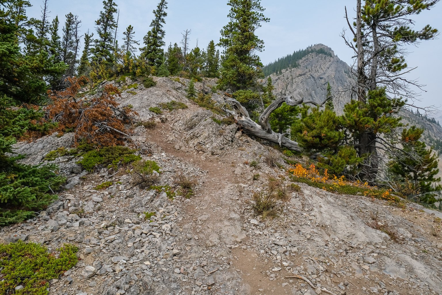
There is one other thing that I realized rather quickly with the Vision Quest trail. It’s bloody STEEP and bloody HOT on a warm summer day! Another thing I noticed pretty quickly was how many trails have formed up the steep south ridge – there are a myriad of them. In general I’d recommend sticking to the ridge crest on ascent and finding some nice dirt / scree runs on descent, making sure you traverse back to the ridge before hitting forested slopes lower down. Judging by some of the worried looks on faces that I passed on ascent, some people get more than they bargained for on this scramble, so beware that aunt Edna might not pay for lunch if you drag her up here without due caution.
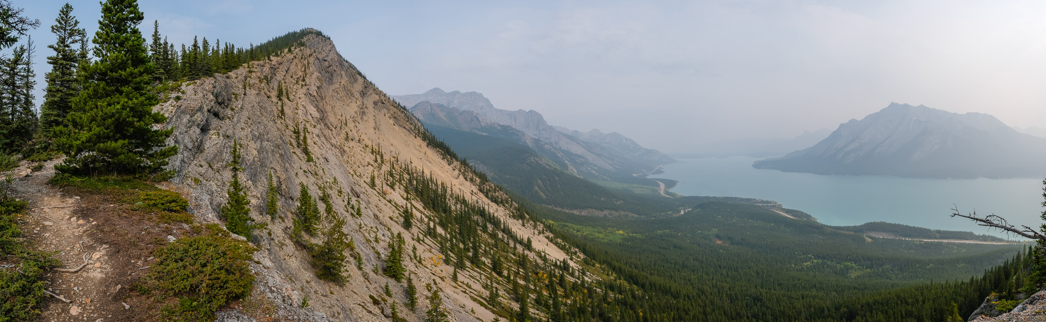

As I hiked towards the highpoint that most people are content to call the “summit”, I noticed a pretty fun looking line to a slightly higher point just NW and decided to try it. Sure enough! There was a moderate line through the lower cliffs and a low difficult line through the next band that had some bolts hammered into the rock next to it. I knew there was an easier bypass for descent so didn’t mind taking the slightly harder line up. Of course as I summited I could see the ridge stretching on for kilometers to the NW. My views of Allstones and Abraham mountains were pretty good and the forest fire haze seemed to be slightly improved as I enjoyed my lunch at another windless summit. I was tempted to keep going along the ridge, but I knew I wasn’t going 4.3kms to the true high point so I didn’t bother. Perhaps another time. Probably not.


Descent was pretty quick. I found some side trails descending loose scree and dirt before cutting back to the main trail where I passed dozens of folks coming up and going down. Vision Quest was much more fun and scenic than I was expecting. It’s Prairie Mountain but with a nice lake (normally) in view and slightly more scrambling if you continue to the high point I did. I enjoyed it despite the smoke and the busy trail.
Great photos Vern. I did VQR a couple of times over the years and in 2006 I went to just below what might be considered the highest point on the ridge. Very broken and slabby scree to go up higher and it was getting late so I returned. Great views of Abraham Lake on the descent.
Alda and I made it this summer to the very end of Vision Quest. Route finding gets interesting higher up.
Wow! I bet. Was it mostly scrambling or some climbing too?
Scrambling only (not for beginners).
You can traverse all the way to Allstones Peak and hike out via BATUS Creek if you have the time/enthusiasm. Perhaps my favourite scramble of 2018.