Summit Elevation (m): 2980
Elevation Gain (m): 1640
Trip Date: Saturday, July 24 2021
Round Trip Time (hr): 9
Total Trip Distance (km): 27
Quick ‘n Dirty Rating: Class 3/4 – you fall, you break something or die
Difficulty Notes: Routefinding along exposed ledges on the upper south face and exposed loose scrambling up the SE ridge to a steep rubble summit gully.
Technical Rating: SC7, RE4
Map: Google Maps (just south of Spectral)
GPS Track: Gaia
First Recorded Ascent: Likely 1890, W.S. Drewry survey party.
The summer of 2021 has been the year of ghostly summits for me. It all started way back in 2009 when I scrambled Mount Aylmer with Keith Bott and first saw the Spectral Lakes area tucked in behind it over Aylmer Pass. When we scrambled Mount Astley in 2015 I got some more tempting views towards Solstice, Spectral and the other ghostly themed peaks nearby. Things really ramped up in a planning sense when Phil and I made a long day trip up Haunted Peak in late Spring 2020. From Haunted we scoped out peaks such as Psychic, Oliver, Stoney, Revenant, Brocks, Apparition, Spectral and Solstice, all of which I’ve now tackled successfully in 2021. It’s kind of strange how much effort is involved in ascending all of the sort-of-named peaks in a pretty small area of the Rockies. I’m screwed if (when) we become like Europe and other major population centers of the world where every single high point gets a label. What I’ve discovered in my rambles up all these peaks is that not only are they all unique characters but they also have many similarities. They are all accessed via good trails (i.e. Cascade fire road, Aylmer Pass) and then untracked valleys (i.e. Spectral Creek, Haunted Creek, Solstice Creek, Unnamed Creek). Many of them have tiered access, especially on the upper peak (Revenant, Apparition, Spectral, Solstice) or convoluted routes (Stoney, Oliver, Astley). Three or four of them I would consider easy other than the approach (Haunted, Psychic, Psychic NE1, Brocks) and of course there’s Mount Aylmer which is by far the easiest as far as routefinding and terrain is concerned, other than an avoidable downclimb along the SW ridge.

After scrambling Spectral Peak with Wietse in late Spring 2021, I contacted Graeme Pole about his FRA of Solstice Peak with John Martin in 1988. Graeme replied to my email;
Solstice Peak is a bit of a mystery object for me. I had either a camera failure or a film failure that day – don’t remember exactly which – so I have no photos to look back on to jog memory for super specifics. One of the dreaded perils of film (which you may know about) was loading a roll and not having it engage. Your film counter ran up every time you tripped the shutter and advanced a frame. But if the film was not feeding onto the take-up spool, you would only discover it when you got to exposure 38 or 39. Oh-oh. I had that happen twice, and I think that Solstice Peak was one of those instances.Your hunch about the route is right. We biked the fireroad and hiked up the drainage you mentioned, taking the north fork where the valley splits. (See attachment.) I remember a lot of sidehill travel in the cirque below the SW face, with some of the traversing being against the grain of the mountain, if you know what I mean – you want to go horizontally where the terrain wants to take you up on ramps that cliff out. The crux was a ledge that led over from the SW face to the S ridge. There was a bit of an overhang above the ledge that wanted to push you off the mountain. I crawled across the ledge while John laughed and hopped over. We didn’t use a rope. There was no snow to contend with when we did it. As far as I recall, the terrain is intimidating up high. We found a weakness (the weakness?) that worked.
Graeme’s recall of the route pretty much matched what I expected from photos and satellite images along with our experience on Spectral Peak where we also had to find a convoluted route up a SE ridge just under the peak. I decided that Solstice would have to wait a bit to ensure it was fully dried off and I was in the mood for a difficult scramble with lots of complicated routefinding. In a follow-up email Graeme detailed some possible hints as to a likely very early FRA for Solstice by a survey team in 1890!
While researching a piece that I am writing, I stumbled onto something concerning Solstice Peak – the first edition (1890) of the NTS Cascade map sheet. It clearly shows the summit of Solstice Peak as having been occupied as survey station A.6, with a spot elevation of 9123 feet. In reading the report of surveyor W.S. Drewry for 1890, he says: “From Banff we went up the valley of Cascade River to Sawback Creek, which we followed to its source. En route we climbed several mountains in searching for a suitable point upon which to place a signal. Intervening peaks, however, hid Cascade signal, and it was not until we reached the head of Sawback Creek that we found a mountain sufficiently high for our purpose.” My guess is that Solstice Peak was one of those “several mountains,” making its first recorded ascent either late July or early August 1890.
As the weekend of July 24th crept up I felt ready to tackle my last remaining peak in this corner of the Palliser Range. Unfortunately (for me), none of my close scrambling buddies could join me so once again I was left to figure it out by my lonesome. I didn’t mind going alone as it lets me go a relaxed pace and pick my own lines. I honestly didn’t think this peak was on anyone else’s radar so imagine my surprise when I looked at my Gaia base map while planning a route and spotted a track from 2020 leading up pretty much exactly along my planned ascent route! It was nice to know that someone made it up the same approximate route I was planning but of course I didn’t have a trip report so there was no way to know if it was a roped climb or hard or easy or what was involved. I could see the track line got a little crazy at the SE ridge which indicated that wasn’t going to be an easy bit…

By 07:30 on Saturday morning I was once again biking up the Cascade fire road from the Lake Minnewanka parkway. This time I was all by myself and the road was even drier than the last time I was up it with Wietse and Phil for our Stoney Peak approach. This was my 5th time up the Cascade road for 2021 – once on skis for Elaphus Peak and subsequently for Spectral, Psychic and Stoney. This ride would be much shorter than the others since I only had to go 5.5kms to the bridge over the Cascade River to access the unnamed creek sitting between Solstice and Astley. The morning was smoky but also crisp and surprisingly fresh as I labored up the familiar hill from the parkway and then along undulating terrain towards the big dip taking me back down to the Cascade River. Within 22 minutes of the truck I was locking my bike to a tree. 2021 is quickly becoming the year of the bike approach for me. I love bike approaches almost more than ski approaches now. I was apprehensive about the access creek. For Spectral Peak Wietse and I had first thought the approach wasn’t too bad, but on return we realized we were definitely mistaken on that hurried assessment. We couldn’t walk in the creek and had to bushwhack above it making for a moderately manky experience. I had no reason to believe that Solstice Peak’s access creek would be any better than Spectral’s – but it was better. WAY better. Way, way, way better! I left my bike at 08:00 and for the next 2 hours I parkoured up a surprisingly clear and fun creekbed for 4.5-5 kms. This was so unexpected that I couldn’t believe how lucky I was getting the higher up the creek I went and kept expecting horrid conditions just around the next bend in the watercourse. But “horrid” never happened.


Don’t get me wrong – this is still a wild, untracked Alberta Rockies creek. There are trees across the channel in places and avalanche debris near open slopes, coming down from high above. But this is also a rare case of the creek flushing out with the 2013 floods rather than filling up with debris. I deviated out of the creek maybe 6 times the entire way up it to avoid the worst debris. Every time I thought I was screwed I could either step over (or under) the trees or there was a short, obvious detour on one of the banks to the side. I haven’t had this much pleasure on an untracked creek approach in quite some time. Eventually I came to an obvious split in the creek and took the north (and larger) branch to my left. From here the route steepened considerably. Eventually I ascended light forest on climber’s left of the creek where willows were choking it up a bit more and soon after I was hiking through lovely alpine meadows presumably leading to a small lake under the south face of Solstice Peak which I still couldn’t quite see.


I hiked past some pretty chill sheep before finally spotting what I hoped wasn’t my peak (but I knew it was). It looked pretty intense but as usual I realized that I had to get my nose into it before judging it too harshly. First I had to find the lake, and this wasn’t as easy as it sounds as the lake was pretty much gone! Thankfully a small trickle of water was still entering into the depression it left behind as the day was quickly getting hot and I was going to need a refill of H2O on exit. Soaring cliffs above the lake were cantilevered on crazy angles making for a very unique landscape. I was forced to look at my peak from the lake and again wondered where the heck the route went and just how it would go.

There wasn’t much to do except point my feet at some obvious gullies breaking through the lower scree towards the intimidating summit block of Solstice, so that’s exactly what I did. I took the most obvious gully up the south face but there was at least one more that likely would have worked. The basic goal was to get just under the fierce walls of the upper summit block along the west ridge before traversing right (east) towards the SE ridge. The stepped terrain up the gully was steep but a lot of fun and very quick to ascend. So far my day was going really well and I was having far more fun than expected, first with zero bushwhacking on the approach and now with solid easy scrambling up the south face. The gully reminded me of the one on Evan-Thomas but was shorter and narrower.


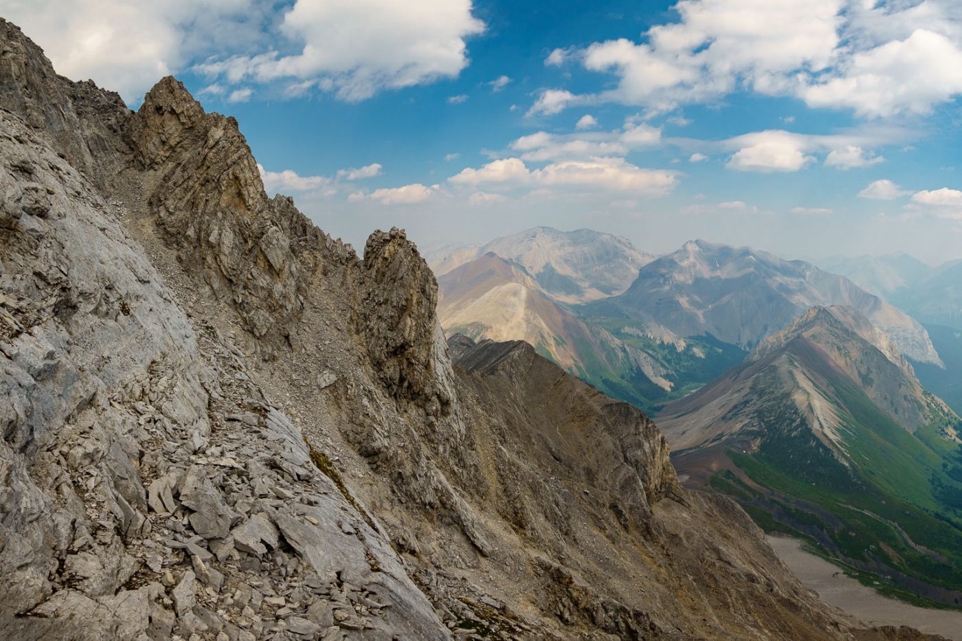
Of course I had to check out the west ridge as I got closer to it, so I did. Of course, as is obvious just from looking at it, the scary outlier didn’t have any easy or obvious route up or around it on either the north or the south side so I was forced to descend a bit before heading out along a series of scree and rubble ledges towards the SE ridge. I was above the other person’s line on Gaia at this point but felt positive that I’d find a route and sure enough – the mountain kept giving me good vibes and good routes every time I poked my head around the next corner. In one case I traversed a narrow scree sidewalk above steep cliffs only about 1.5 feet wide! It was good fun but careful routefinding was key to keeping things reasonable for solo scrambling.


Eventually I spotted a small window on an overhang just before arriving at the SE ridge proper. I was happy to be above the other line on my map as the ridge didn’t look easy to ascend from below my traverse route. I scrambled up steep terrain just before the window before exiting the south face to the south ridge. The ridge looked pretty steep and exposed above me at this point and I was wondering where the heck I was supposed to go in order to keep this a “scramble”. As usual in the Rockies, a reasonable route opened up as I ascended the ridge, sometimes I had to poke around or back off silly terrain but there was always an option to keep going. There were three key moves up the SE ridge. The first was traversing a solid but small ledge just climber’s left of the ridge crest where the top was a knife edge and VERY unstable. I could have traversed over it but this would have been dumb and unnecessary due to the tiny edge just below the crest. The second key move was losing about 10m of elevation down a gully and then back up to the ridge, once again on climber’s left to avoid a horribly exposed and loose ridge crest. The third key was traversing a scree ledge which looks like it will get you to a steep, loose gully under the summit but ends in steep slabs. I turned back here before scrambling back up to the ridge crest and getting to a scree traverse to the steep gully. I know this description is sort of nebulas but it does highlight the need to be a natural routefinder on this peak!


Even after dealing with the SE ridge I was left with an exposed traverse on scree above a steep slab and scree gully dropping down the east face below in order to access a final loose, steep gully leading up to the summit. I managed to awkwardly squirm my way over the exposed slope before starting up a horribly loose gully to the summit. At this point I decided that I would definitely be rating the scramble as “SC7” or “difficult”. I scrambled up the gully and finally popped out on the summit near a small rock cairn. My views were surprisingly good considering all the smoke in the air and I enjoyed a few minutes taking in some food and water before turning my mind back to the descent, hoping I’d remember the few different key areas on descending the SE ridge. I’d built cairns along the ledges so wasn’t concerned about that. I searched around pretty hard for a summit register (Graeme usually leaves one) but I couldn’t find anything.


Descending the loose, steep gully under the summit was tricky but not too bad (I was glad to be solo here with tons of rockfall). The traverse across the top of the east face back to the SE ridge from the bottom of this gully was easier on the way back than it had felt on approach but still begged not to be taken too lightly. A slip here would have dumped me on steeply tilted slabs which would be very hard to slow down my fall all the way down the rest of the east face.


Descending the SE ridge was pretty quick – I remembered all the key route choices and was soon back under the window and traversing cairned ledges back to the access gully up the south face. The return along the scree ledges also went much quicker on descent (no more routefinding) and soon I was in the ledged gully on the south face and enjoying the moderate steps to rubble slopes below.


The herd of sheep was at the trickle of water leading to the dying lake and we shared a few minutes of peaceful coexistence. I laid back against a rock nearby with a fresh bottle of water and watched two kids playing in dappled sunlight coming through the weirdly shaped cliffs over the dry lakebed. Usually sheep are much more skittish with kids around but for some reason they didn’t see me as a threat today. They probably saw how slowly I climbed the mountain and figured they could easily outrun me if it came to that. After 20 minutes or so I reluctantly got up and started wandering back out of the upper alpine towards the creek below.

As usual for creek routes, the afternoon dragged on a bit longer than I would have liked while descending the open creekbed in a baking hot afternoon summer sun. The route was still fun and easy but creek parkouring gets hard on the knees after many hours of it. I was very thankful to have hiking poles. I was also thankful that the lower creek was running more than that morning and I could get a refreshing drink and dunk my head in it before arriving back at the bike near the Cascade River.


The bike ride was easy and quick. I was surprised that it took me almost 9 hours for this trip but travel in the creek wasn’t blindingly fast and neither was careful routefinding on the mountain. Solstice Peak far exceeded my expectations both on the approach with almost no bushwhacking and on the peak with interesting routefinding and some difficult scrambling to the summit. I’ve said this on a few scrambles so far this year, but Solstice had just enough of everything I look for in a scramble and not too much that I don’t look for. I’d recommend going when there’s slightly more water in the approach stream and the upper tarn but this would also mean possible snow which would be an issue on the face traverse. Early July most years would likely be perfect for this objective.
Nicely done, dude!
Thx! You’ll like this one.
Hey, Vern, you climbed so many mountains around the area, could you suggest the easiest ones to summit from Cascade fire road? Including the total distance vs difficulty and approach issues. I’d like to start with something and boost my confidence.
Cheers in advance.
Hey Adrian,
Elaphus is by far the easiest provided you get across the Cascade. Otherwise maybe Stoney Peak.