
Summit Elevation (m): 2823, 2706
Trip Date: Saturday, June 15, 2019
Round Trip Time (hr): 10
Elevation Gain (m): 1850
Total Trip Distance (km): 36
Quick ‘n Dirty Rating: Class 2/3 – you fall, you sprain or break something, class 4 to the highest point on Armstrong
Difficulty Notes: A long day even on bikes. Mostly pretty easy and straightforward until the summit ridge of Mount Armstrong which is easy to moderate scrambling. The true high point on Mount Armstrong is difficult scrambling with a tricky down climb.
Technical Rating: SC6; RE4
GPS Track: Gaia
Map: Google Maps
After my adventurous solo outing on Mount Hensley only a few days previous, I wasn’t sure I was entirely prepared for the long bike ‘n scramble Phil and I had planned for Saturday, June 15th. We’d been planning a trip into the Fording River Pass area for a few years already and June seemed like an ideal time for such a venture. Back in July of 2017, my daughter and I spent a few magical days in the Carnarvon Lake area just north of the Fording River Pass. While in the area we scrambled both Mount Maclaren and Shankland which offered great views of Mount Armstrong and Bolton and they’d been on my radar ever since. We knew from Andrew Nugara’s guidebook that bikes would be hugely helpful in making the 35+ kilometer day more manageable but other than that there were very few details online about the Fording Pass area or its approach from the east. The Daffern’s had a blurb on their Kananaskis Blog about roads being overlaid on the old indian trails up Baril Creek (on hindsight we found this statement odd in that the logging roads / exploration trails weren’t that new anymore). After firming up our plans for Saturday the weather forecasts slowly deteriorated until we were debating the wiseness of our decision. A new year’s resolution for me was to go out in more “bad weather” so this turned out to be a perfect opportunity to test that resolve.
Biking up Baril Creek and Ascent of Mount Armstrong
We met at the Baril Creek parking spot as indicated by Nugara and the Dafferns. I’d been here before for my Coyote Hills hike back in 2014. Thinking that the Daffern’s comment implied a new logging / exploration road we spend a few confused minutes looking around for a freshly cut swath up Baril Creek before shrugging our shoulders and starting up an obvious track just above our parking spot. Apparently the “old indian trail” up the creek must have been overlaid by the “new” trails and roads quite a few years ago now. The weather was glorious as we biked the undulating trail for the next 2 hours.


The way was mostly obvious with a few bridge crossings and one non bridged crossing of Baril Creek deep enough to get our feet wet. The only confusion was that the Great Divide Trail (GDT) refused to follow the obvious (and much more bikable) snowmobile trail as it neared the pass. The trail seemed to lose a lot of height in some sections on approach but on return these weren’t as bad as we were expecting.

We followed the GDT / snowmobile trail right up to an open scree / rocky area right at the toe of Armstrong’s south ridge. This was probably a bit too far for the bikes since it necessitated some very steep uphill pushing, reminiscent of our two trips to Middle Kootenay Pass. But you have to try right? After the longish bike ride we were more than ready to start hiking and stop pushing our two-wheeled steeds uphill! We were perfectly situated on Armstrong’s south ridge at this point and could see an easy line straight up to the false summit on the southwest ridge above. The only issue? We had no water at this point since we’d been counting on crossing Baril Creek one more time… Hmmm. Oh well. We decided to continue along the track until crossing some running water before gaining the south ridge.


From where we ditched our bikes we followed the obvious snowmobile trail down towards the creek before finally getting ourselves back on the official GDT as it wandered towards a rushing stream coming off Mount Armstrong. We filled our water bottles under a beautiful, energetic waterfall along the creek before crossing on a makeshift bridge (that was a little underwater, ironically) and starting up towards the south ridge of Mount Armstrong.


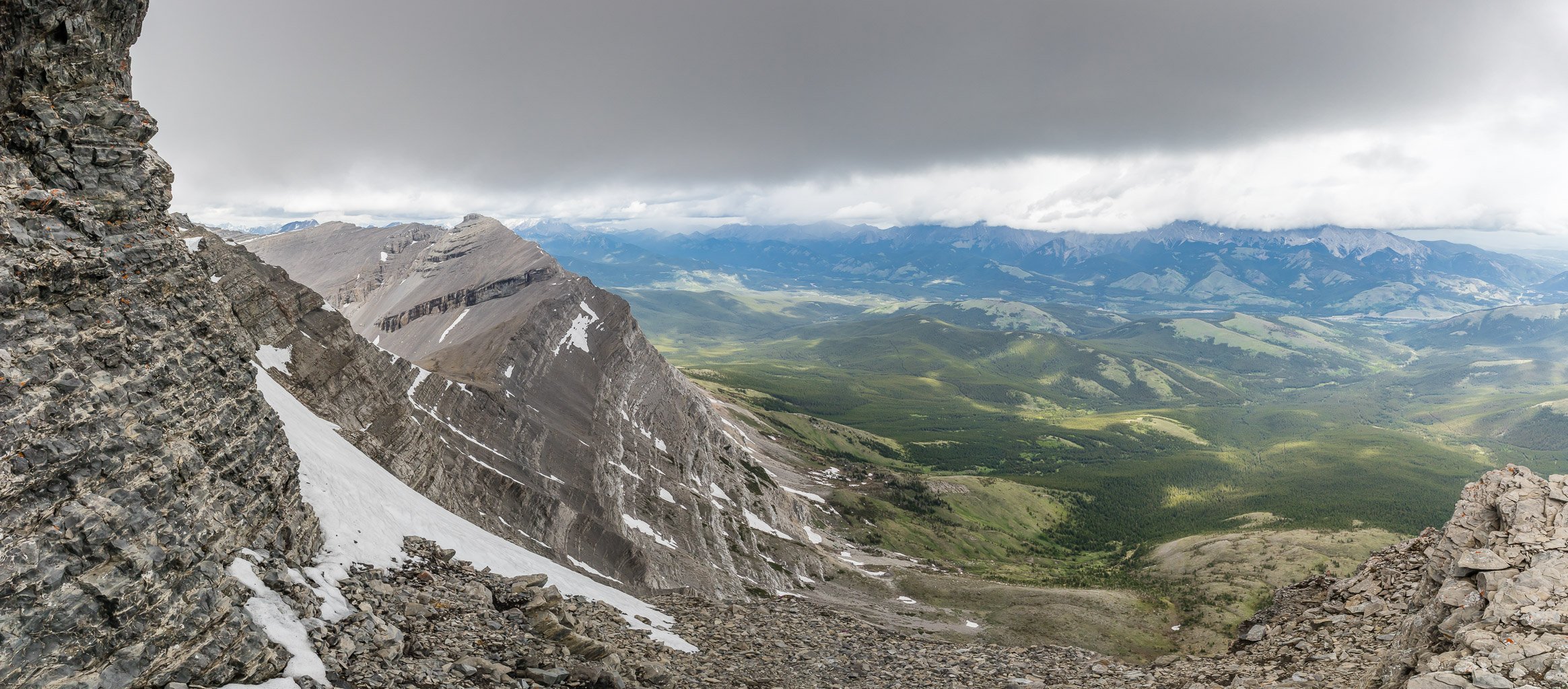
The next few hours were once again pure hiking magic. Sure! The weather was a bit gloomy and we felt the odd drop of rain, but the cool air, fresh flowers and stunning views back to Baril, Cornwell and Courcelette more than made up for any hint of gloomy weather. I was struck yet again by how important it can be to ignore the forecasts some days and just head out your front door and deal with whatever happens. As we ascended the easy south ridge it was amazing how we had almost clear views into BC to the west and low clouds / rain towards Mount Burke to the east. Quite the opposite of how the weather systems usually roll over the Rockies! The flowers were amazing all over the pass area, including Pasque flowers, Paintbrushes, carpets of Shooting Stars and Primrose. It was all very distracting for me. I literally can’t walk past a wildflower without at the very least acknowledging it. I’m not sure what that’s all about but it’s a thing with me.


Thanks to the cool air and great views we were soon at the false summit on the southwest ridge with pretty stellar views towards MacLaren, Shankland, Bolton, Courcelette, Cornwell and Baril Peak. When we turned our attention to the summit it didn’t look far but I cautioned Phil that Nugara specifically calls this out. The summit is further than it appears. In this case Nugara was even more correct than he thought, but we’ll get to that later. The southwest ridge was pretty straightforward, but indeed took longer than expected. While it’s only around 100m of vertical gain, it has enough undulations and slow terrain to take around 25 minutes to traverse. This doesn’t sound long, but it looks like a 15 minute easy stroll from the false summit and it’s basically double that, so keep this in mind when you do it. As we strode up to the giant summit cairn (likely built by the Boundary Commission in 1918) we both immediately noticed something very surprising and a bit jarring.


The cairned summit of Mount Armstrong was quite clearly NOT the highest point!! Goshdarnit!! The weather was starting to move in as we made an immediate decision to attempt a traverse to the highest point, looking pretty close along the southeast ridge. We took quick measurements of the altitude at the cairned summit just to be sure and kept going. At first the SE ridge was fairly easy. Than it very clearly wasn’t. I have to admit that when we hit the cliff along the ridge I was ready to give up and just claim the easy cairned summit like everyone else clearly does (there was two registers in it). But there was a nagging feeling in the back of my head that forced me to slow down, ignore the looming clouds of doom and give the downclimb along the ridge a closer look. I reluctantly turned back to the task at hand and began descending. Long legs and solid(ish) holds helped get down the slightly overhanging crux and soon I was at the bottom of it, guiding Phil as he followed.

With the weather moving in rapidly, the remainder of the easy (somewhat exposed) ridge seemed to take longer than it actually did and within around 15 minutes of leaving the cairned summit we were greeted by a 1-rock cairn on Armstrong’s highest point. (We were moving very quickly due to the weather so I would count on closer to 25 minutes with the crux downclimb.) We took more altitude measurements including with an altimeter app on my iPhone that calibrated with the nearest airport thanks to cell reception. The altitudes on both summits were different than the official ones, but the point is that relative to each other and based on very obvious visual evidence, the SE ridge summit is definitely higher than the cairned one. We figured the difference at about 4-5m, which isn’t much but it’s more than zero! The question for any subsequent scramblers of this peak is what they are satisfied with to claim the “summit”. I don’t really care what you do, it felt pretty great to suss out a difficult route and tag the true high point.


The clouds were whipping up the east face as we hurried back to the giant cairn. As usual, climbing up the nose of the crux was much quicker and easier than descending it and soon we were at the cairn. Despite looking like Armageddon, the clouds proved to be rather harmless so we forced ourselves to take a bit of a break before continuing back along the SW ridge to the false summit. I quickly scanned the two registers which were nothing more than random bits of paper.


After enjoying a quick break and confirming again that this summit was indeed lower (taking another reading within 10 minutes of the high point) we started down the ridge towards Bolton, feeling pretty good about our day so far!
Ascent of Mount Bolton and exiting Fording River Pass
Phil and I were feeling pretty good about talking ourselves over a difficult crux to get to the true high point on Mount Armstrong as we descended the SW ridge to Armstrong’s false summit. We took another short break here, looking over at Mount Maclaren and Shankland brought back some good memories for me from a trip with my daughter in 2017 to the Carnarvon Lake area. From the false summit of Armstrong, Mount Bolton looked dead easy and it was.

We descended straight down the SW ridge of Armstrong to the Bolton col with no issues. There were some loose bouldery sections and some minor cliff bands but nothing more than easy scrambling. The wildflowers near the col were ridiculous, causing some near hysteria in certain members of our party. After tearing ourselves away from the gorgeous scenery at the col we started up the NE ridge of Bolton on surprisingly stable, bouldery scree.
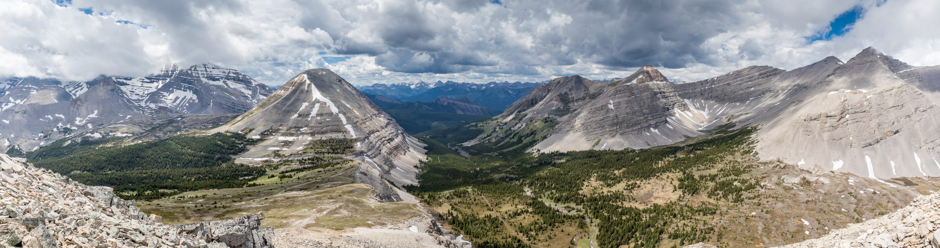

The views into the valley between Bolton and Shankland were stunning, as were the views towards mountains further into BC including Abruzzi, Joffre and Harrison. This was strange only because Armstrong was now covered in clouds that were threatening from the east. Very weird. The ascent of Bolton’s NE ridge went quickly and within about 50 minutes of leaving the col we were traversing the blocky summit ridge to a summit cairn built up on the highest bit of ground (not 5m lower this time ). The views were still great to the west – we couldn’t believe how lucky we were getting considering the forecasts for this day. To the east there was more and more cloud building but we were enjoying a spot of sun on our peak and didn’t overthink things. A bit of rain on exit wouldn’t hurt. As expected the views of Courcelette, Baril and Cornwell were once again stealing the show. The Fording River Pass looked sublime from Bolton’s summit, with green alpine pastures and little muddy tarns.


All too soon it was time to start heading back down to the pass and from there, our bikes. This was the crappiest terrain of the day by far. We descended SSE slopes to the pass below on very blocky, loose terrain that reminded me a bit of Mount Shankland – although much less scary on Bolton. It was a short descent and soon we were hiking over the Fording River Pass in a cool Spring breeze, headed for a couple of signs and presumably a trail that would lead us back to our bikes.


After hooking up with the return snowmobile track we quickly walked over the lovely pass. We wondered where exactly the GDT was since we suspected it wasn’t following the wide track. We were right. Eventually we noted a much smaller trail peeling off to our left and we followed it. This smaller trail cut back and forth across the snowmobile track but avoided following it at all costs. Eventually we noticed we were near our original ascent line for the south ridge of Armstrong and soon we were crossing the same underwater makeshift bridge near a familiar set of falls along a creek. We stuck to the GDT this time, coming out near the bikes but still off the much larger snowmobile track. It was strange how the two trails tried their hardest not to merge!


The bike ride back was much easier and quicker than we expected. On approach we thought the exit would be quite tough but in reality there was much more down than up and even the “up” wasn’t very difficult for the most part. I didn’t even bail over my handlebars this time! Must have been easy…

I was suitably impressed by my first foray into the Fording River Pass area to want to go back there someday. The bike ride is a bit of work but the further you ride / push your two wheeled beast of burden, the more fun you’ll have on exit.
Thanks for putting this together. I can’t wait to explore the area next year.
You’re welcome! It’s a beautiful area.
Hello , its great see more people enjoying the area . You’ve taken some great photos . See you out there sometime . Heading out there spring 2020. My first there was spring ‘75
Lani Smith
Founding member GDTA
Right on! It’s a beautiful area. Thx for the work you’ve done to make it even better.
I very much enjoyed seeing the photos and reading the descriptions of the trek. I frequented the area in the 60’s and 70’s, & I also fished in the lakes and caught lots of cut-throat trout. No mountain bikes,just lots of walking, & wading across the Highwood River in cold ,waist -deep water. I recall that climbing up the back of Armstrong was like climbing up a barn roof.
Your “Meadow “ as you described about 7.5 km from road is actually the Old Revolstoke Saw mill site from the early 1950s,
The old original trail , as marked by “Blazes” on trees that is seen in some sections of the trail is the Stoney Indian Trail , that has been there for hundreds of years. AND is the MUCH DESIRED ROUTE TO FOLLOW NOT THE SCIESMIC LINE ! In 1967 Shell Canada did oil exploration up the pass which destroyed much of the Old Indian Trail .
Interesting!
[…] Aldridge and Courcelette Peak on the second day. I would be following Vern Dewit’s routes for both days, staying at the lake at the top of the pass […]