
Summit Elevation (m): 3120
Trip Date: August 08 2015
Elevation Gain (m): 2200
Total Trip Distance (km): 26
Quick ‘n Dirty Rating: Class 3 – you fall, you break something
Difficulty Notes: A very remote peak, the main difficulty will be having enough energy to complete it!
Technical Rating: SC6; YDS (3rd)
GPS Track: Gaia
Map: Google Maps
Photos: View Album
After a long day on Corona Ridge where I was dealing with a stomach flu, we awoke at 04:30 surprisingly willing to tackle another long objective in the area – Marmota Peak. After staring at it for hours from our scramble of Corona Ridge, we were excited to see if our chosen route would go. The route was easy enough to spot – a high-line traverse (more side-hilling!!) along ridges and cliffs beneath South Totem and Spreading Peak before ascending a gully to a ridge abutting the west face of Marmota. From here we’d gain the upper ridge and traverse to the summit – one of two high points at the southern end. Unfortunately it was obvious from Corona Ridge that the cooler looking south peak was lower than the other two, and our GPS units confirmed that it was about 80m lower. The plan worked remarkably well. After a quick breakfast we were on our way in the dark. Steven led masterfully around the first part of the traverse until finally the day slowly dawned and we could navigate without head lamps. Of course the side-hilling was starting to wear a little thin by this time, but we slowly made our way past lovely hidden tarns and up more cascading streams until we were finally on the approach to our key access gully.
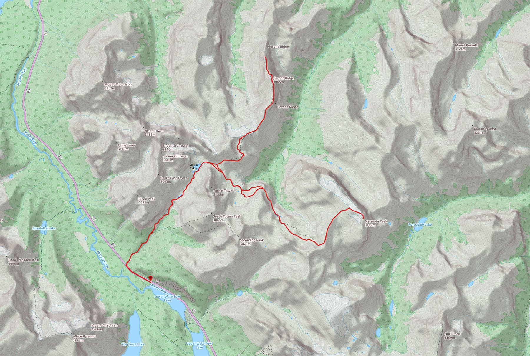


Annoying moraines blocked easy access and once again we were plodding up and down them before passing one last tarn and starting the loose ascent of the gully. Where the gully steepened, we cut climber’s left to gain the summit of the sw-ne ridge to Marmota’s west face. Even this ridge had some height gain / loss but the views were absolutely gorgeous on this clear, cool summer morning so we weren’t complaining. We even walked briefly on a remnant glacier before finally looking up at the 400 remaining vertical meters to the summit of Marmota, gained via black limestone steps with verglass and steep scree slopes. It took us almost 4 hours to this point, so a 5 hour ascent from the bivy was looking possible.

After ascending the slick, frozen dinner plate scree of Marmota’s west face we found ourselves with a heckuva view on the upper ridge of the mountain. A small glacier on the east side provided great views as we continued climbing straight up the ridge. We finally reached the summit around 5 hours after leaving our bivy and this was at a pretty fast pace. The views were absolutely mind blowing in the great morning light. No haze, no smoke and no obstructions. The summit measured at 3120m on both our barometric GPS units – well above the official height of Corona Ridge.


It was surprising how many remnant glaciers exist in this area. A few hundred years ago this must have been quite the icefield. I was determined to find an original ascent register, since we were sure that we were only the 2nd or 3rd ascent of this peak – it is way in the middle of nowhere. I almost gave up but persevered and I finally spotted a small film canister buried in the collapsed summit cairn! Yes – this is always a very exciting thing on a remote summit because you never know whose names you might find. The last time I found an original summit register was on Hooge Peak and that one was from 1946! This one was soaking wet but as I delicately unfolded the sheet of paper I could still read it. It was 43 years old and from the guidebook husband & wife team of Tony and Gillian Daffern! So cool. They ascended Marmota from Noyes Creek in 1972 – three years before I was born! I replaced their record with a dry sheet of paper and added our names. A possible 2nd ascent but I can’t know that for sure. I do know that not many folks have stood on the summit of Marmota Peak. Looking south we wondered if the crumbly summit there was any higher. Only one way to find out – we made our way over and up the loose pile of rocks. Nope. It is also 3120m and only because of the rickety cairn on it. After a ton of summit photos we prepared for the long descent.


Our descent was fairly easy – simply retracing our ascent route. There were lots of ups and downs, of course, and tons of side-hilling again. Thankfully there was a nice cool breeze the entire time, making the summer heat bearable. We arrived at our bivy pretty stiff and sore from the previous 24 hours of exercise, but our trip time of 9 hours was excellent so we took half an hour to relax at camp before packing up and heading back up to the Totem col.


The day was quite warm as we worked our way back down Totem Creek to highway 93 but there were no difficulties other than the pain of even more side-hilling. When we got to the highway we found ourselves plodding along the black top with a lineup of cars waiting for the construction to let them past. Our parking plan worked perfectly as it was just ahead of the lineup. The construction workers I chatted with along the highway were quite surprised when I told them where we’d been. I heard them exclaiming as I walked away that they couldn’t imagine just “bushwhacking into the middle of nowhere” like we just did. It felt really good to get a couple of lesser known summits that are very lofty and extremely scenic and worthwhile. I’ll be back up Totem Creek one day to tag some more peaks back in the Spreading Creek Valley, but I’ll have to let my mind forget the nasty side-hilling first.