
Elevation Gain (m): 700
Trip Date: July 22, 2017
Round Trip Time (hr): 7
Total Trip Distance (km): 22
Peaks Ascended: MacLaren, Shankland, Strachan, Muir, McPhail, Hill of Flowers
Quick ‘n Dirty Rating: Class 3 – you fall, you break your leg
Difficulty Notes: The crux just below the lake is a set of chains that ascends upper moderate to low difficult scrambling terrain. The combination of a big pack and the exposure could turn some hikers around.
Technical Rating: SC6; RE2
GPS Track: Gaia
Map: Google Maps
Note: Since posting this trip report the Carnarvon Lake area has reportedly become quite popular. I don’t know if that’s because of my report or sheer coincidence but if you’re reading this please, please, please be a better citizen than others have apparently been. I’ve heard stories of between 12 and 15 parties all camped at the lake along with people drinking, chopping down trees and acting like idiots. Y’all know better than this! The quickest way to shut down an area is to act like it’s your own personal backyard. I guarantee you the lake will be shut down to camping sooner than later if this continues. Sorry for the rant, but it is extremely disappointing to hear these stories (I’ve heard half a dozen or more now). Please educate yourself on minimal camping techniques or stay in your yard if you just want to party.
For our father / daughter backpacking trip in the summer of 2017, Kaycie and I eventually settled on a 5 day, 4 night backpacking and peak bagging trip around the Carnarvon Lake / Weary Creek / Lake of the Horns area of the High Rock Range in Kananaskis Country along the Great Divide. We planned for a two night stay at Carnarvon Lake with a ramble up a few of the easy peaks in the area before we’d traverse over Mount Muir towards Weary Creek Gap. After spending a night at Weary Creek and possibly ascending Mount McPhail, we’d traverse over to Lake of the Horns for our last night. On our return we’d loop over Hill of the Flowers before hiking down McPhail Creek and back to the Cat Creek parking lot.

I was concerned about thick smoke from a myriad of forest fires burning in BC during our time out in the wild, but there wasn’t much we could do about that so we finalized our plans and decided to make do with whatever conditions were thrown our way. After the short drive from YYC to the Cat Creek parking area along highway 940, we strapped on our packs and set off down through the flood-damaged, closed, Cat Creek day use area along the Highwood River. (Update 2019: Apparently this day use area is open again and you can park here now.)
Interesting Facts on Carnarvon Lake
Carnarvon Lake is rumored to be one of the most gorgeous lakes in Kananaskis Country. This is a bold claim, but one that I can agree with now that I’ve been there. It demands a price for enjoying its gorgeous scenery, however, in the form of a long tedious approach and an exciting moderate / exposed scramble up its headwall.
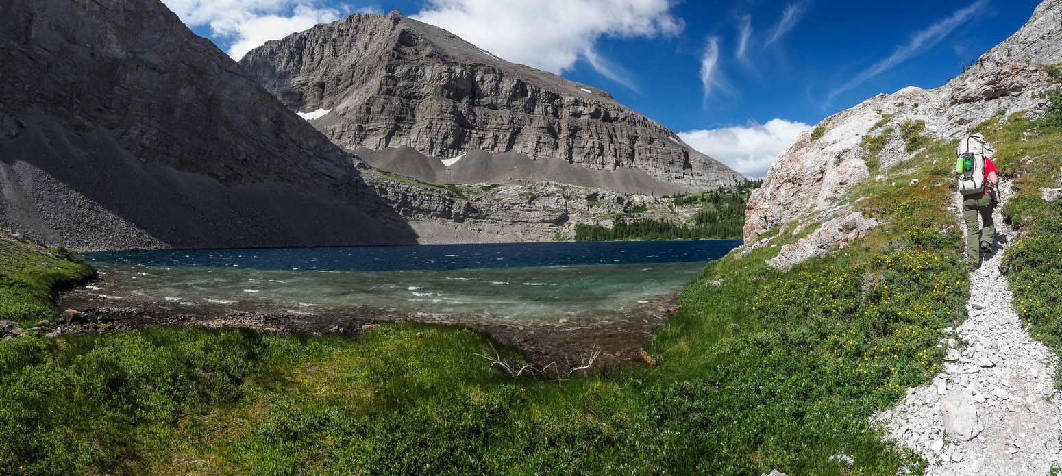
Many people choose to bike (or ride horses) along the approach to Carnarvon Lake and I can see why. Since we were doing a loop and returning via McPhail Creek instead of Carnarvon Creek we didn’t have that option. Biking with multi-day packs is literally a pain in the butt anyway – at least it is for me since I don’t bike enough. We passed a few tents in the barricaded day use area before wandering along the Highwood River for a few easy kilometers to the crossing. The river crossing was surprisingly deep! KC almost got her iPhone wet as the water reached the bottom of her pockets at one point. I can see that crossing in early July might be a difficult prospect. After the crossing we bore down and followed my GPS track towards Carnarvon Lake’s infamous headwall.


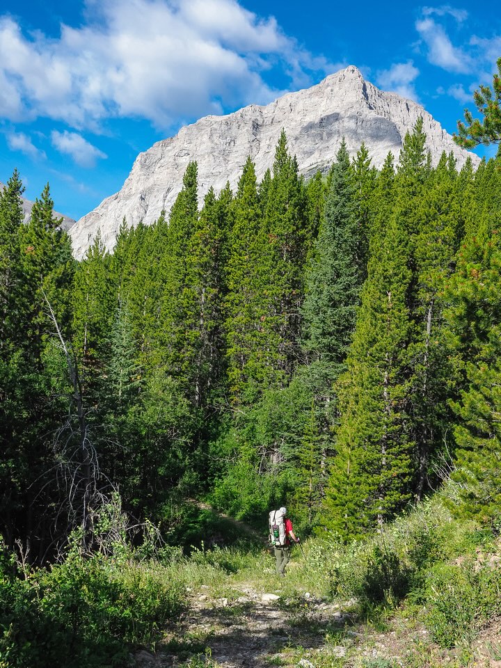
I’ve read more than one complaint on the ‘boring’ approach to the headwall, but KC and I enjoyed the solitude and beautiful morning immensely. Looking forward to a week off and some nice relaxing hours by a pristine backcountry lake does wonders for the attitude I suppose. The approach surely isn’t exciting in a Lake O’Hara or Louise sense, but the birds were chirping and flowers blooming everywhere and it was hard to feel sorry for ourselves as we chatted and walked through the still morning air. I have to say that I was glad to have a GPS track to follow. There are a ton of trails in the area and things can get confusing quickly! This is a very popular horse riding area as well, so we got to enjoy their distinctive smells along the way. After about 1.5 hours our trail turned uphill, deviating from a connector to the Fitzsimmons Creek trail, and became bushier and much narrower.

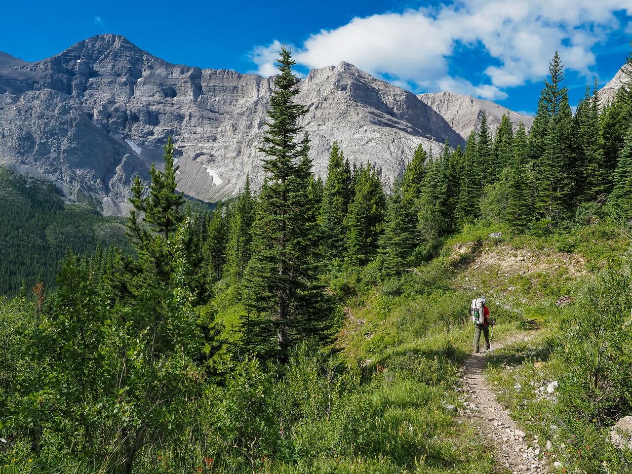
I was surprised by the lack of drinkable water along this approach. I don’t like carrying water in the backcountry because it weighs so much, but on this trip I ended up worrying about water sources more than I’m used to. I even forgot my chlorine treatment as I so rarely need it in the Rockies. Most people will want to carry at least a few liters along on this approach. With the horse traffic and local bovine population, any water sources are suspect without treatment even if you do come across any. The day was growing quite hot as we finally got our first views of the headwall and hiked across a scree slope towards it. I could see right away that it wasn’t going to be easy.
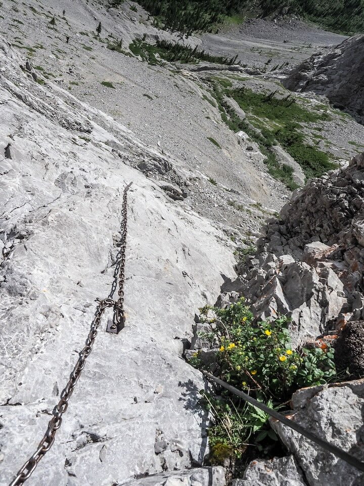
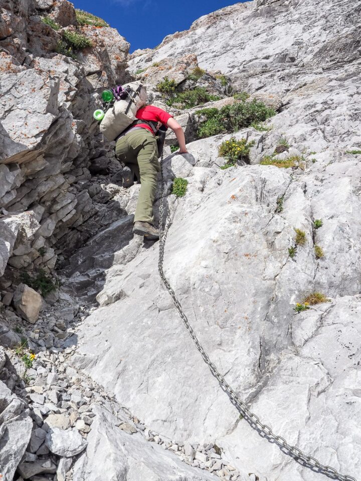
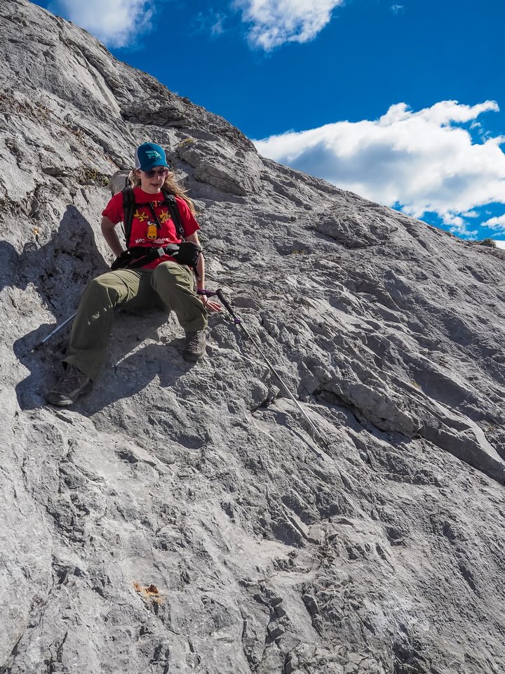
The headwall has surprised people with its difficulty in the past. It’s a funny thing, because some people swear a child can easily ascend it and others want to call it difficult and exposed scrambling. Now that I’ve done it, I think both views are partially correct. There is a reason that there’s chains here! Sometimes chains seem like overkill (i.e. Crowsnest Mountain) but this isn’t one of those times. Especially with a multi-day pack, the terrain up the chains feels exposed and at least upper moderate scrambling. I think without the chains, this would likely be considered a difficult scramble. Put it this way – I was nervous watching KC climb up the terrain – chains or not! A slip on certain parts of the ascent would certainly result in severe injury and likely death. That being said, the rock on the headwall slab was very grippy and the chained area was mostly cleared of any loose debris. Obviously, the chains add a lot of security as well. Don’t underestimate them and if you’re comfortable with scrambling and some exposure you’ll have no issues with the headwall – at least on ascent. As we topped out of the crux we met a group of four ready to descend. This was good news as we knew we’d have a campsite for the next few nights. Looking back down the chains, I was secretly happy that I wouldn’t have to watch KC descend them – we’d be leaving this area via a different route that involved traversing over top of Mount Muir.


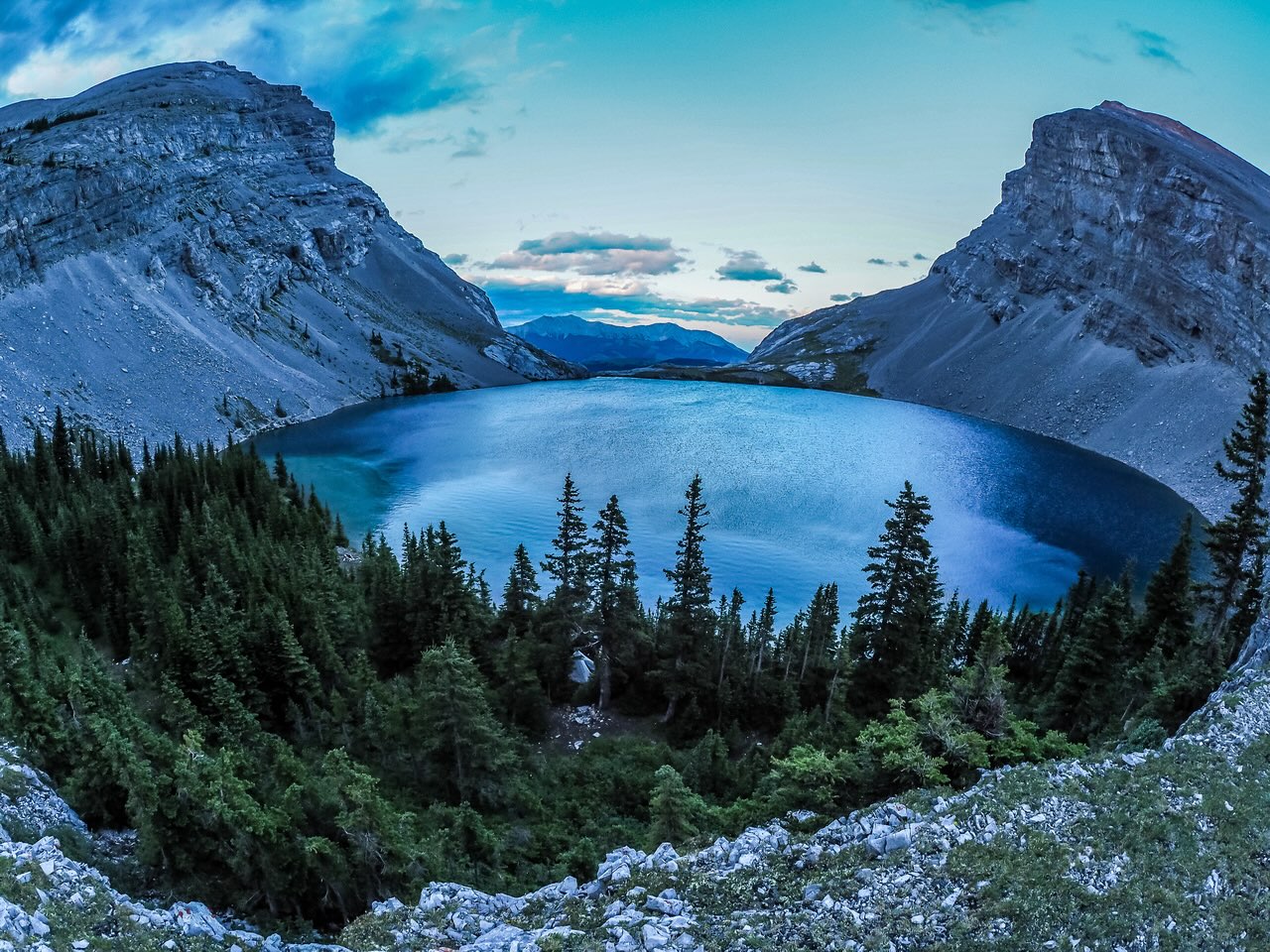
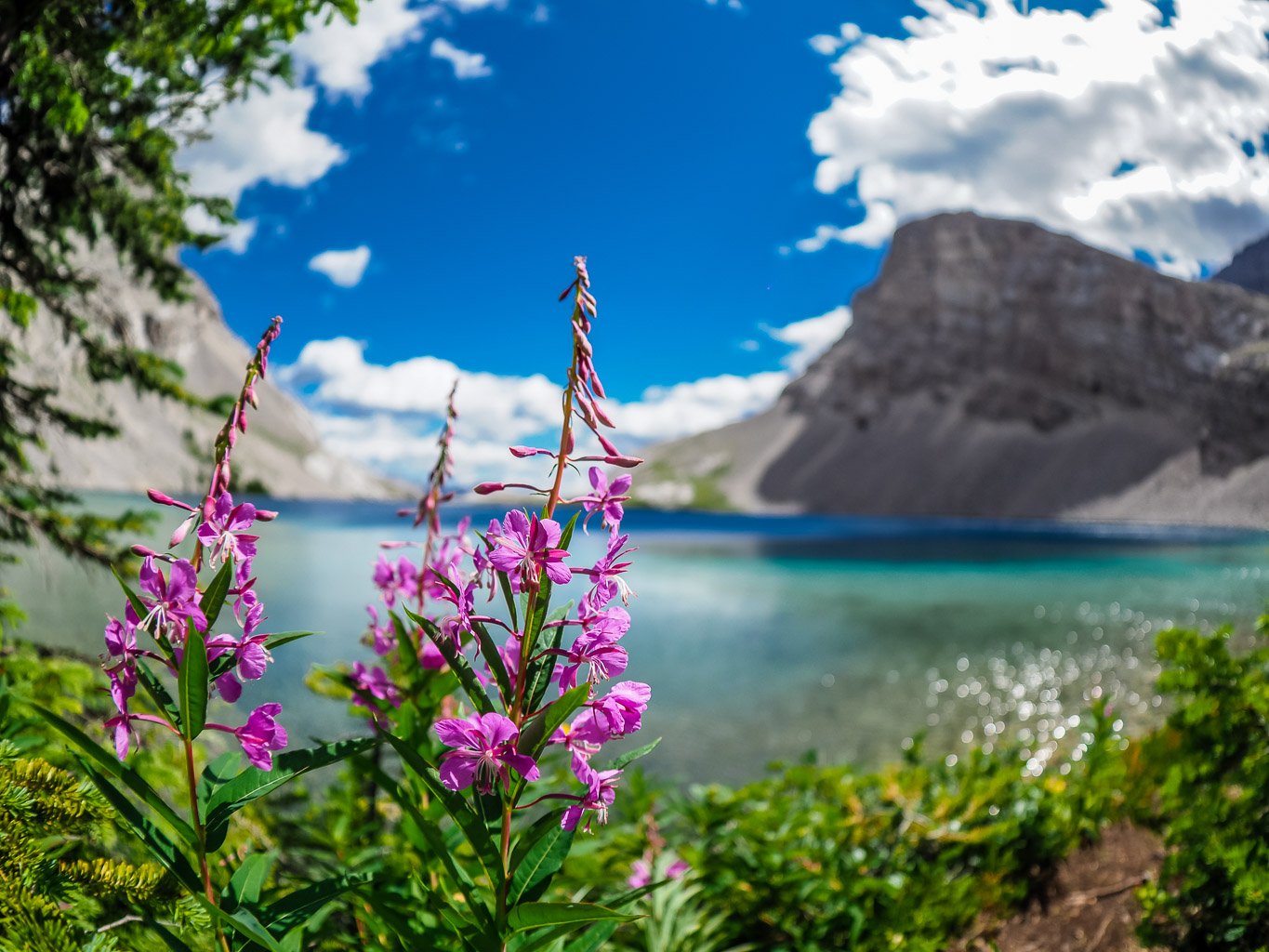
Soon after finishing the headwall we got our first glimpse of the stunning blue waters of Carnarvon Lake. The impact was lessened a bit by the gale force wind that was whipping the surface of the small lake into whitecaps and threatening to blow us back over the headwall, but we knew right away that this area was pretty special. As we traversed around the lake to the treed shore at its far (west) end, we couldn’t help but be impressed with the combination of the deep blue colored lake and the soaring rock walls coming down from Mount MacLaren to the south and Mount Strachan above us on the north.
Even the trail around the lake had one section which could result in a slip if the rocks were wet or the hiker not careful enough. We expected people to be at this very popular destination and there were. It was a weekend, after all. Two groups were staying in the trees on the west end of the lake but despite this, we still managed to find a perfect little spot just off the lake and as sheltered as it gets – which isn’t very. Despite being in trees, we’d find out over the next two days that the winds that come whipping down from between Mount MacLaren and Strachan are fierce and tough to block. Even reading our books or eating supper in our treed site would result in the occasional gust strong enough to cover us and our gear with a layer of dirt and dust! Better than mud I suppose.
Our little bivy area was private enough that we didn’t see the other groups very much, and we enjoyed our little bit of solitude immensely. Because it’s located in the Don Getty Wildland Provincial Park, random camping is allowed at Carnarvon Lake. It was a little bit disappointing to see the other groups ignore the fire ban that was currently in place, but other than that I was very impressed with the cleanliness of the area. There was no evidence of human waste or garbage anywhere that we could see, and I spent a few hours exploring the shoreline and lake area when we had down time.


On one of my excursions I hunted around for the rumored hidden campsite buried in a patch of Kruppelholz on the eastern shore of the lake and managed to find it. What a cool site! Probably the least obvious and coolest camp site I’ve ever seen in the backcountry. I wished on more than one occasion that I’d brought my fishing rod along. The lake is stocked with Cutthroat Trout, which seemed to be very hungry while we were there.

Obviously, we weren’t just at the lake to lounge around and watch the fish jump – we had peaks to bag! There are at least four summits that are quite easily attained from a base at Carnarvon Lake including MacLaren, Shankland, Strachan and Muir. Other peaks that are accessible but via pretty long days include Armstrong, Bolton and Muir SW2. Despite all our peakbagging, we managed to spend many hours relaxing with our e-readers and enjoying the lake.

I would highly recommend you take at least a few days to enjoy this area, rather than just run in and out as a day trip. It is a beautiful area that rewards with stunning views and easy peaks. There are at least 4 or 5 viable campsites and most folks in the area seem to be quite responsible with their litter and detritus (well, apparently that was short-lived – see my note at the beginning of this post). After dreaming of visiting this area for many years, I have to say that it still exceeded my expectations.
thank you, happy trails!
We are suprised we have been up 4 times the last 11 years have not see a single person all day
Idiots should not be there report them next time only take a phone call , CO ‘s will be there to check it out
Not a lot of CO’s around either… 😏🤷🏼
Just went there yesterday. Definitely it is the most beautiful lake in K-country. The chain scramble freaked me out but I made it. Happy trails!
Glad you enjoyed it!