
Summit Elevation (m): 2778
Trip Date: Thursday, August 16, 2007
Elevation Gain (m): 1400
Round Trip Time (hr): 8
Total Trip Distance (km): 15
Quick ‘n Dirty Rating: Class 4 – you fall, you break something or worse
Difficulty Notes: A fall on the crux would severely injure or kill so take necessary precautions.
Technical Rating: SC7; YDS (4th)
GPS Track: Gaia
Map: Google Maps
Photos: View Album
After scrambling Mount Warspite and Mount Storelk the previous two days, Thursday, August 16 2007 seemed like the perfect day to grind up Wapta Mountain and complete 3 difficult scrambles in 3 days after 2.5 weeks away from the mountains. So that’s exactly what I did! This time I was joined by Wietse, Jason and Kevin Barton. Wapta Mountain has always interested me because of the purported views and the difficult crux which seems to surprise most people with it’s level of difficulty. I love the Yoho area for it’s amazing views and good approach trails. The day started off with JW stuffing 6 bottles of beer in his pack for later enjoyment.

The hike to the campground by Yoho Lake was pleasant and it was here that the beer got hidden under a log in the lake. We continued up the excellent trail and soon were enjoying views of the ‘other side’ of the Presidents and the impressive waterfall coming off the south glacier. The hike is longer than you may expect, it must be close to 6km each way, but it was a lot shorter than my trip up Mount Field. (OK – that was a ridiculous amount of work for such an easy peak, I admit it, but we were desperate for a summit at the time!)
Once we came to the gully we wasted no time heading right up the middle of it. Raff had mentioned that the middle of the gully was fun scrambling on the way up and that the trees to climber’s right were better saved for the way down so we listened to his advice – and it paid off. The gully has some moderate to upper moderate scrambling in it, on smooth water-worn slab that can get pretty steep in spots. You can usually bail out of it to the left or right if it gets to prickly for your taste, but if you can’t handle the scrambling in the gully you won’t be liking the crux on the summit block very much and should probably continue on to Mount Field or stick to hiking for the day.
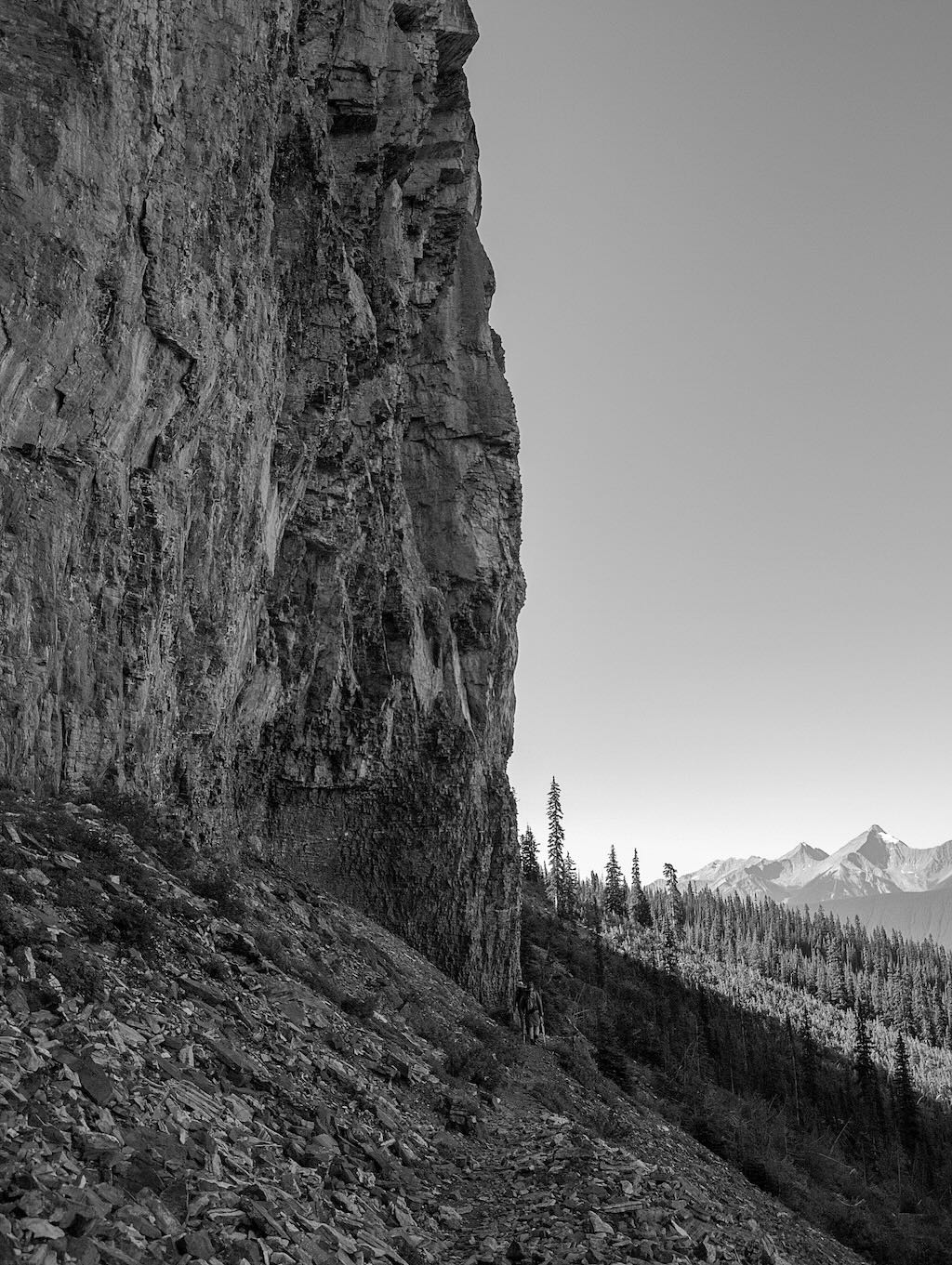


Once we got near the top of the gully we scrambled slightly to climbers right and straight over the first cliff band – heading for a cairn that could just be seen on the top. The scrambling through the lower cliff bands was quite enjoyable. You may be tempted to go way over to climbers right where the cliff band completely deteriorates into scree but if you can find the break closer to the ascent gully you will save yourself a lot of scree bashing and will have a much more enjoyable scramble, IMHO.


After we broke through the first cliff band we could see another band above us. It looked like there was a way directly up and through this band too. We headed up very broken scree and boulders for another break in the cliffs and this was quite loose but only moderate scrambling at best.

Once through this last cliff band we were in the upper bowl before the summit block. JW headed off for the slopes to the east of the summit block (he would have to traverse west to meet up with us on the west side of the block later) while the rest of us followed the odd cairn and bits of broken trail up the scree to climbers right and the northwest corner of the block.


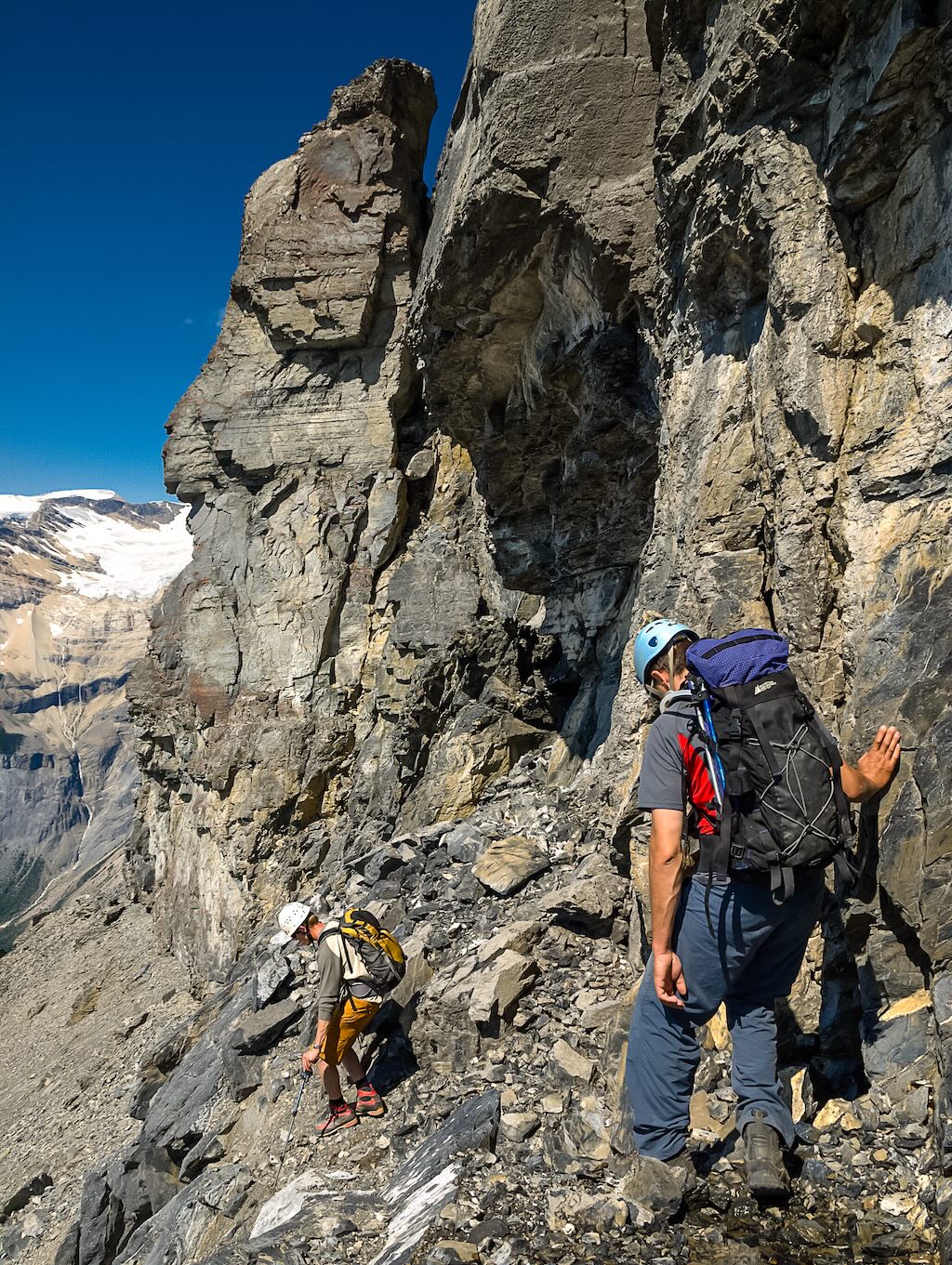
Testimony to the looseness of the upper terrain came in the form of a huge cloud of dust and rock from the summit as we were clambering up this final scree field. Once at the summit block we waited for JW to join us and then proceeded to traverse under the steep cliffs towards the south end of the block and our route up to the summit.


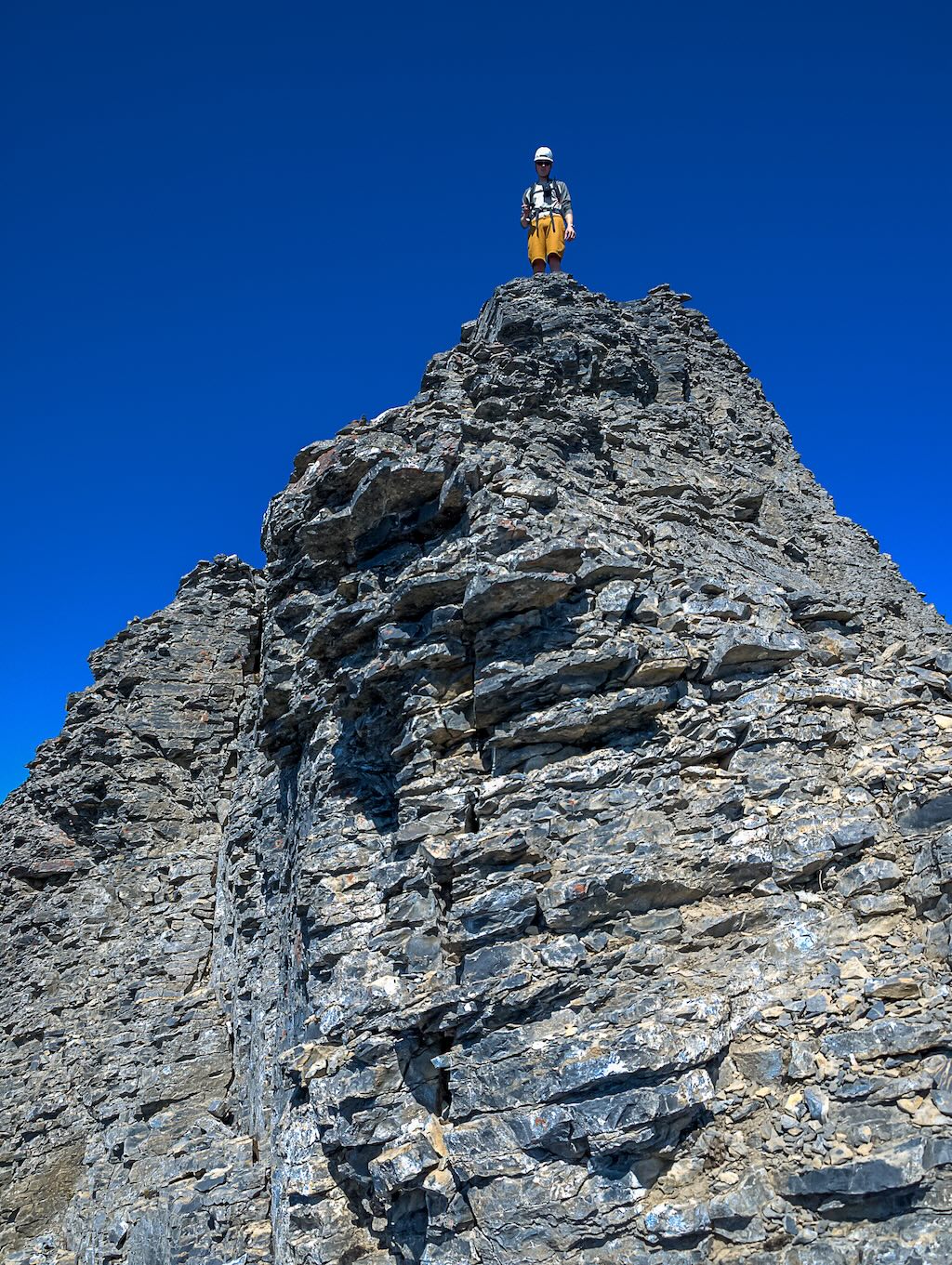
As we traversed up alongside the summit block we naturally ended up on a ledge that worked its way along the steep cliffs. The ledge eventually became a bit exposed and we had to stretch to get over some broken bits on it. We kept looking for the Kane route markers but didn’t see any obvious ones. Eventually we came to a point where JW thought we could get up onto the south ridge and so we clambered up using a slightly awkward move and we were there. The route we took did not seem very heinous to us and we knew that we had somehow missed the Kane route but found an easier one while we were at it! The final bit to the summit was quite exposed and loose but not that bad and soon we were enjoying the wonderful views of the surrounding peaks including the Goodsir Towers, Mount Vaux, Laussedat, Carnarvon, the Presidents, Wapta Icefields summits, Niles, Daly etc.


After almost an hour on the summit we decided that the clouds to the west were looking a bit soggy and we should get down before we looked soggy too. Wietse and Kevin led the way back down the summit ridge. I was kind of bummed that we hadn’t gone up the Kane route. I wanted to test my scrambling skills against Kane’s difficult rating and the register entries had me even more curious about the crux. (Generally people were not in favor of labeling it as a ‘scramble’ route.) On my way up the summit ridge I had noticed where the Kane route topped out, and could see the route was well marked with small cairns on the way down. I yelled to JW behind me that we should give it a shot but he didn’t sound so keen on that plan so I kept going down our ascent route.


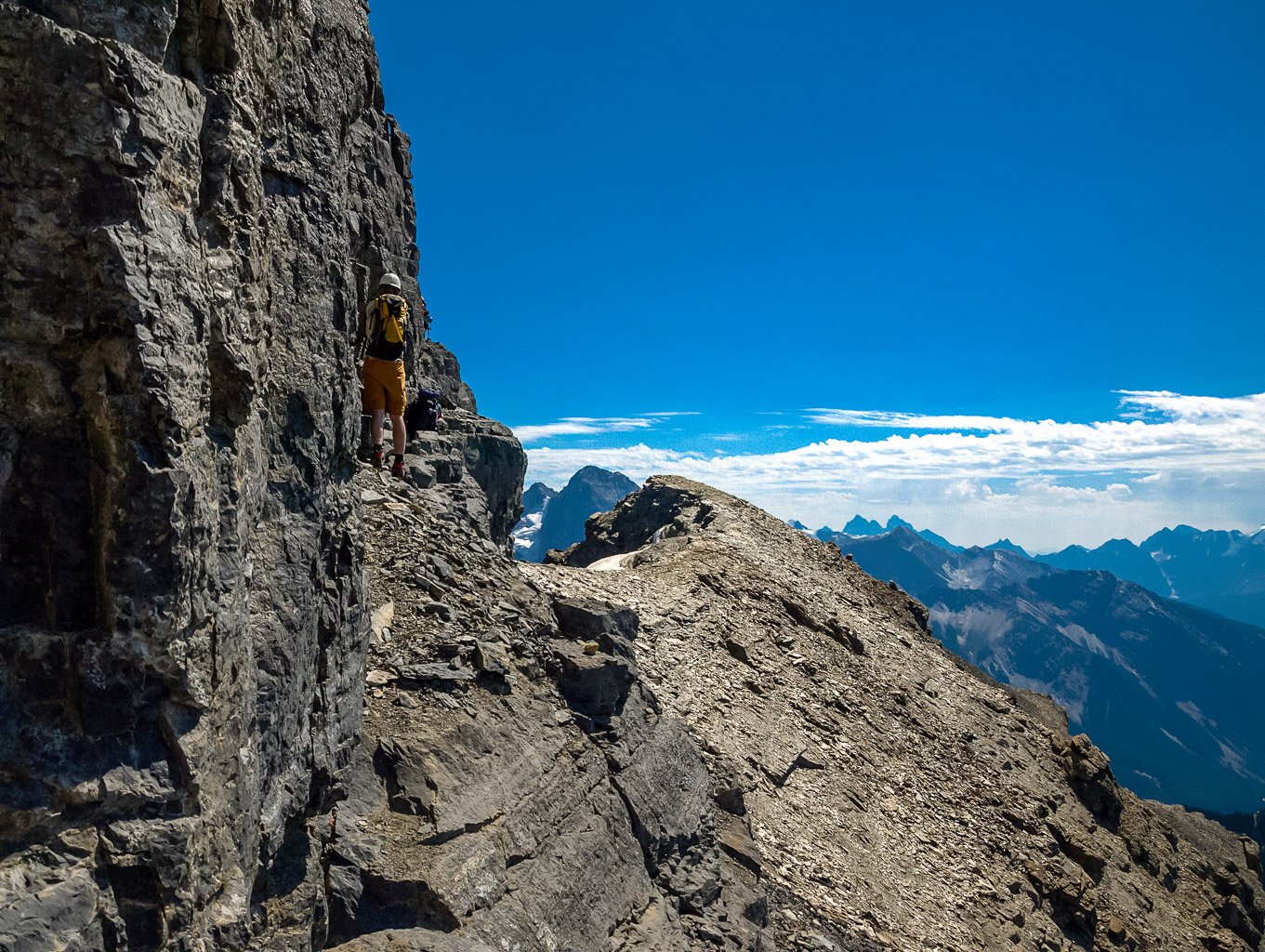
I guess the wheels got to turning in JW’s head because as he passed the Kane route he yelled down to me that it was “worth a shot” and so I scrambled back up to meet him and we started down the route. Right away it became obvious that this is a whole other ball ‘o wax compared to our ascent route. The Kane route is more difficult. It’s more exposed, much steeper, longer and looser than our ascent route.

Unless you like down climbing loose choss, where every handhold, no matter how large seems determined to come down on top of your melon, I would highly recommend NOT using the Kane route on this mountain. JW and I both made it down no worse for the wear – and I was glad I did it because I would have always wondered otherwise, but since there is such an obvious route around this crux it almost seems foolish to tempt the scrambling deities.

There were no cairns marking our ascent route and we didn’t cairn it either, but if you simply continue past the Kane route, almost completely to the south end of the summit block on the ledge (it will be obvious), you can’t miss it. I think Dow Williams must have picked a very similar line to ours but I can’t be sure of that. Even the ledge route was ‘difficult’ but compared to the regular Kane route it is much safer IMHO. Wietse and Kevin both said that it was a bit tricky to descend but the level of involuntary clenching seemed considerably less than what JW and I had just experienced.

After the summit block we retraced our ascent route through the cliff bands and tackled the steep scree slopes on skiers left of the ascent gully. Eventually we ran into a faint trail with flagging and soon were back at the Wapta high-line trail. Back at the lake JW immediately downed his beer while lounging in the frigid water!

The rest of us stayed dry until the sun came out and I joined JW. I am not cold blooded like he is so I only lasted about 3 minutes but he must have been in there for at least 10 or 15. Once the beer was gone, it was time to head back and we enjoyed some good laughs and impressive views of Takakkaw Falls before finishing another awesome day in the Rockies.


